Evergreen Topo Map Mississippi
To zoom in, hover over the map of Evergreen
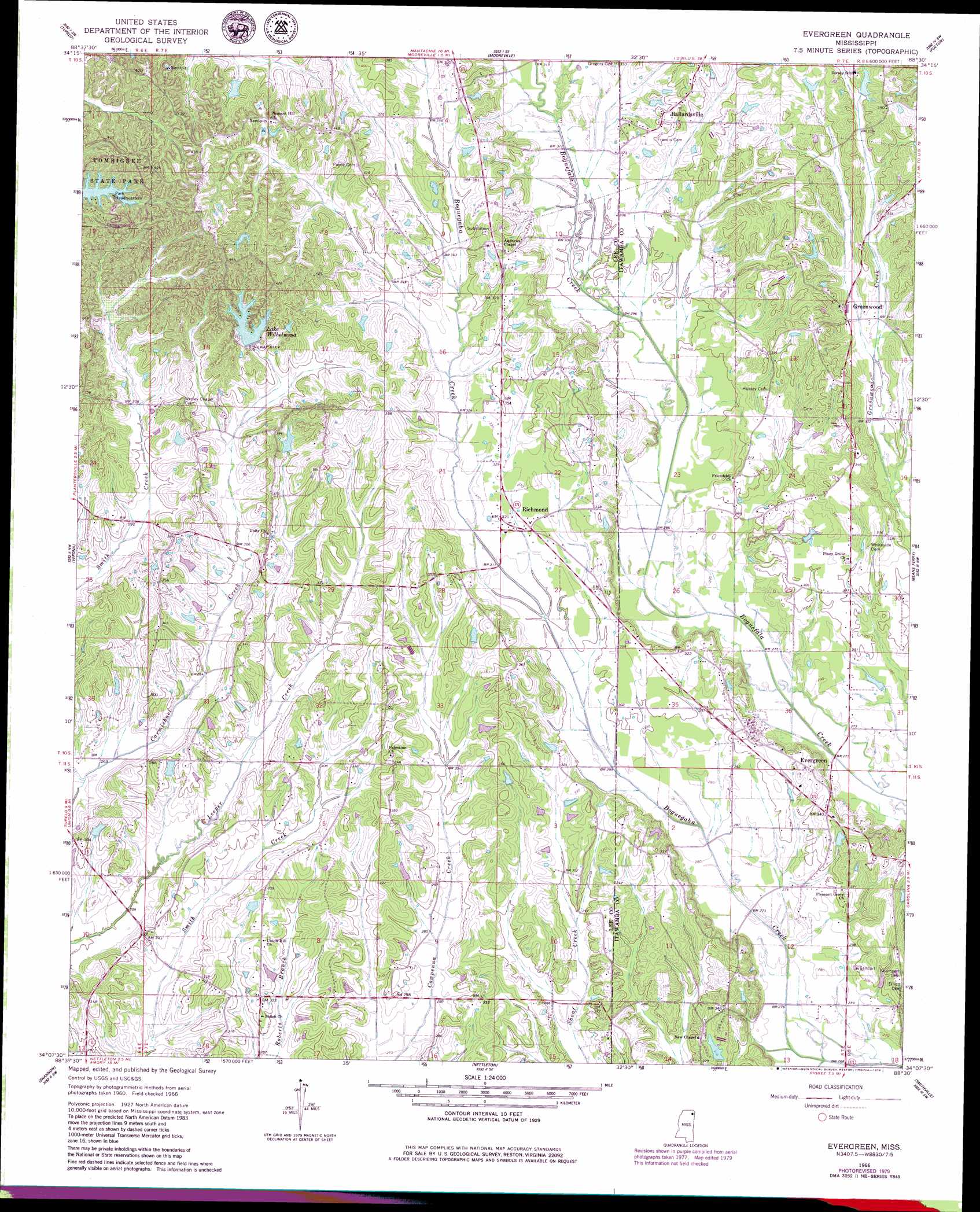
USGS Topo Quad 34088b5 - 1:24,000 scale
| Topo Map Name: | Evergreen |
| USGS Topo Quad ID: | 34088b5 |
| Print Size: | ca. 21 1/4" wide x 27" high |
| Southeast Coordinates: | 34.125° N latitude / 88.5° W longitude |
| Map Center Coordinates: | 34.1875° N latitude / 88.5625° W longitude |
| U.S. State: | MS |
| Filename: | o34088b5.jpg |
| Download Map JPG Image: | Evergreen topo map 1:24,000 scale |
| Map Type: | Topographic |
| Topo Series: | 7.5´ |
| Map Scale: | 1:24,000 |
| Source of Map Images: | United States Geological Survey (USGS) |
| Alternate Map Versions: |
Evergreen MS 1966, updated 1967 Download PDF Buy paper map Evergreen MS 1966, updated 1979 Download PDF Buy paper map Evergreen MS 1966, updated 1979 Download PDF Buy paper map Evergreen MS 2012 Download PDF Buy paper map Evergreen MS 2015 Download PDF Buy paper map |
1:24,000 Topo Quads surrounding Evergreen
Ellistown |
Guntown |
Ratliff |
Kirkville |
Fulton Ne |
Sherman |
Tupelo |
Mooreville |
Fulton |
Fulton Se |
Bissell |
Verona |
Evergreen |
Beans Ferry |
Tremont |
Troy Se |
Shannon |
Nettleton |
Smithville |
Turon |
Buena Vista |
Egypt |
Wren |
Amory |
Greenwood Springs |
> Back to 34088a1 at 1:100,000 scale
> Back to 34088a1 at 1:250,000 scale
> Back to U.S. Topo Maps home
Evergreen topo map: Gazetteer
Evergreen: Dams
Lake Wilhelmina Dam elevation 113m 370′Lake Willow Manor Dam elevation 98m 321′
Pennington Lake Dam elevation 101m 331′
Rick Luther Lake Dam elevation 85m 278′
Woodman of the World Lake Dam elevation 119m 390′
Evergreen: Parks
Tombigbee State Park elevation 119m 390′Evergreen: Populated Places
Ballardsville elevation 108m 354′Evergreen elevation 84m 275′
Greenwood elevation 97m 318′
Richmond elevation 98m 321′
Shiloh elevation 97m 318′
Evergreen: Reservoirs
Lake Wilhelmina elevation 113m 370′Evergreen digital topo map on disk
Buy this Evergreen topo map showing relief, roads, GPS coordinates and other geographical features, as a high-resolution digital map file on DVD: