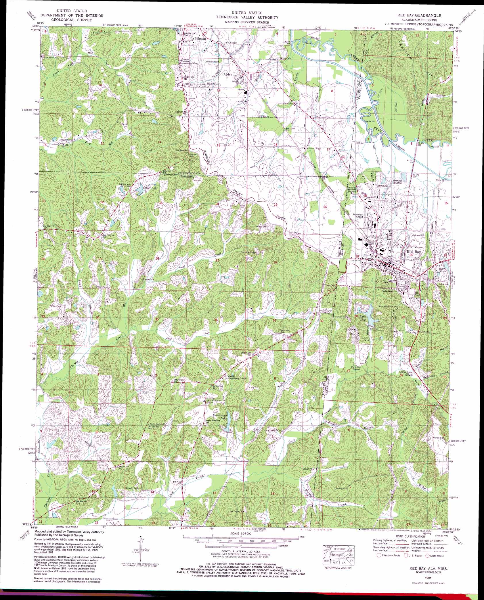
Red Bay Topo Map Mississippi
To zoom in, hover over the map of Red Bay
USGS Topo Quad 34088d2 - 1:24,000 scale
| Topo Map Name: | Red Bay |
| USGS Topo Quad ID: | 34088d2 |
| Print Size: | ca. 21 1/4" wide x 27" high |
| Southeast Coordinates: | 34.375° N latitude / 88.125° W longitude |
| Map Center Coordinates: | 34.4375° N latitude / 88.1875° W longitude |
| U.S. States: | MS, AL |
| Filename: | o34088d2.jpg |
| Download Map JPG Image: | Red Bay topo map 1:24,000 scale |
| Map Type: | Topographic |
| Topo Series: | 7.5´ |
| Map Scale: | 1:24,000 |
| Source of Map Images: | United States Geological Survey (USGS) |
| Alternate Map Versions: |
Red Bay AL 1936, updated 1936 Download PDF Buy paper map Red Bay AL 1951, updated 1951 Download PDF Buy paper map Red Bay AL 1951, updated 1973 Download PDF Buy paper map Red Bay AL 1951, updated 1976 Download PDF Buy paper map Red Bay AL 1981, updated 1982 Download PDF Buy paper map Red Bay AL 2011 Download PDF Buy paper map Red Bay AL 2014 Download PDF Buy paper map |
1:24,000 Topo Quads surrounding Red Bay
Altitude |
Paden |
Tishomingo |
Bishop |
Barton |
Marietta |
Paden Se |
Belmont |
Pleasant Site |
Pleasant Grove |
Kirkville |
Fulton Ne |
Red Bay |
Halltown |
Guinn Cross Roads |
Fulton |
Fulton Se |
Shottsville |
Vina |
Hodges |
Beans Ferry |
Tremont |
Bexar |
Weston |
Hamilton |
> Back to 34088a1 at 1:100,000 scale
> Back to 34088a1 at 1:250,000 scale
> Back to U.S. Topo Maps home
Red Bay topo map: Gazetteer
Red Bay: Airports
Red Bay Municipal Airport elevation 183m 600′Tishomingo County Airport elevation 173m 567′
Red Bay: Bridges
Golden Bear Creek Bridge elevation 151m 495′Red Bay: Crossings
Epps Ford elevation 151m 495′Red Bay: Dams
Audrey O Oliver Pond Dam elevation 148m 485′Bates Dam elevation 151m 495′
Berry Lake Dam elevation 173m 567′
Senter Lake Dam elevation 155m 508′
Weatherford Lake Dam elevation 154m 505′
Red Bay: Populated Places
Golden elevation 168m 551′New Bethel elevation 151m 495′
Red Bay elevation 197m 646′
Red Bay: Post Offices
Coke Post Office (historical) elevation 130m 426′Merora Post Office (historical) elevation 178m 583′
Pleasant Ridge Post Office (historical) elevation 202m 662′
Red Bay Post Office elevation 191m 626′
Red Bay: Reservoirs
Bates Lake elevation 156m 511′Berry Lake elevation 177m 580′
Red Bay: Streams
Bullen Branch elevation 154m 505′Bullen Branch elevation 155m 508′
Clear Branch elevation 150m 492′
East Fork Chubby Creek elevation 129m 423′
Epps Branch elevation 148m 485′
Gee Branch elevation 150m 492′
Gee Branch elevation 150m 492′
Horton Branch elevation 152m 498′
Long Branch elevation 149m 488′
McBrayer Branch elevation 150m 492′
McKinney Branch elevation 153m 501′
Murphy Branch elevation 134m 439′
Murphy Branch elevation 134m 439′
Page Branch elevation 132m 433′
Posey Branch elevation 125m 410′
Prairie Branch elevation 149m 488′
Ray Branch elevation 125m 410′
Sanders Branch elevation 158m 518′
West Fork Chubby Creek elevation 129m 423′
Red Bay digital topo map on disk
Buy this Red Bay topo map showing relief, roads, GPS coordinates and other geographical features, as a high-resolution digital map file on DVD: