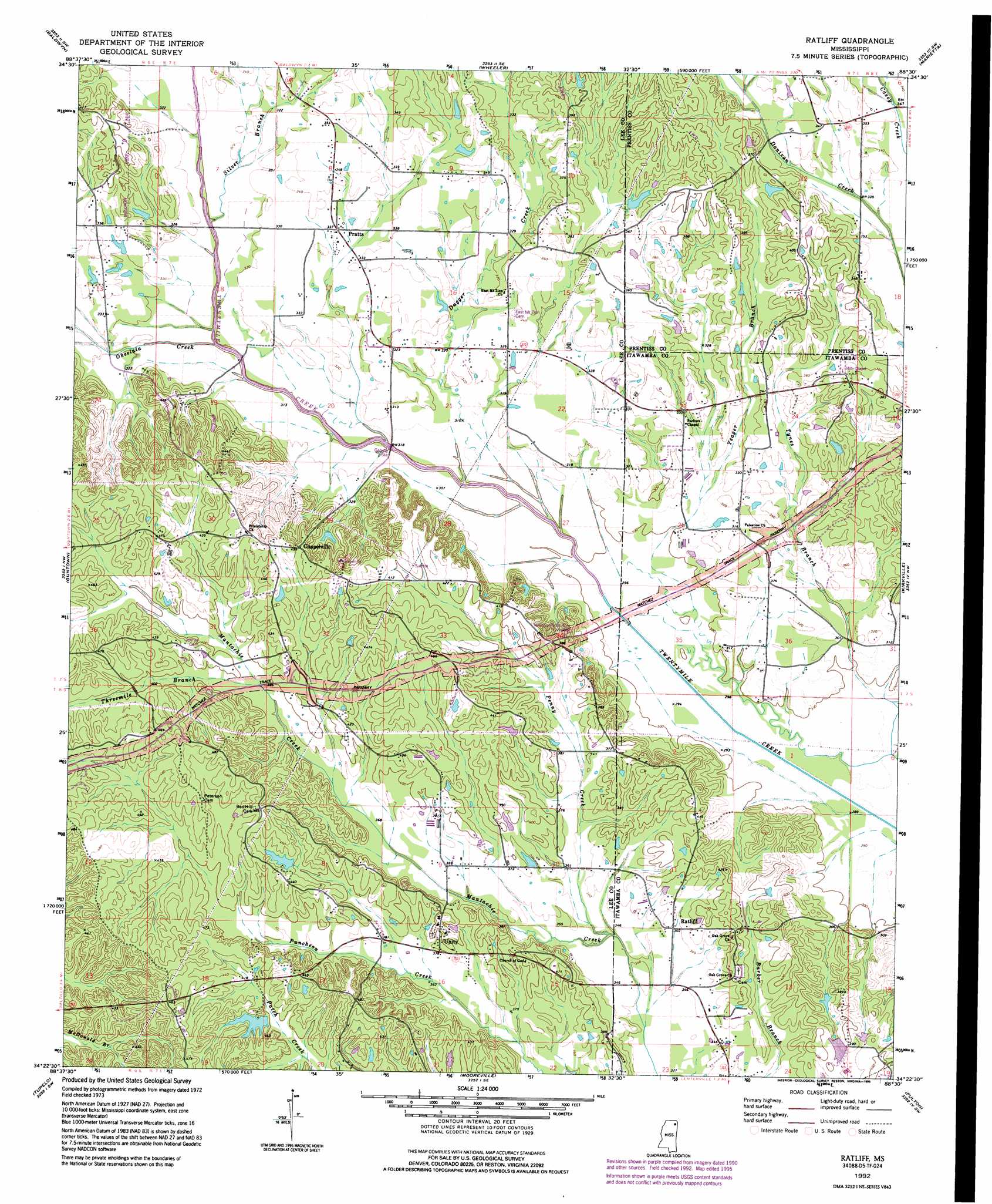
Ratliff Topo Map Mississippi
To zoom in, hover over the map of Ratliff
USGS Topo Quad 34088d5 - 1:24,000 scale
| Topo Map Name: | Ratliff |
| USGS Topo Quad ID: | 34088d5 |
| Print Size: | ca. 21 1/4" wide x 27" high |
| Southeast Coordinates: | 34.375° N latitude / 88.5° W longitude |
| Map Center Coordinates: | 34.4375° N latitude / 88.5625° W longitude |
| U.S. State: | MS |
| Filename: | o34088d5.jpg |
| Download Map JPG Image: | Ratliff topo map 1:24,000 scale |
| Map Type: | Topographic |
| Topo Series: | 7.5´ |
| Map Scale: | 1:24,000 |
| Source of Map Images: | United States Geological Survey (USGS) |
| Alternate Map Versions: |
Ratliff MS 1973, updated 1975 Download PDF Buy paper map Ratliff MS 1992, updated 1995 Download PDF Buy paper map Ratliff MS 2012 Download PDF Buy paper map Ratliff MS 2015 Download PDF Buy paper map |
1:24,000 Topo Quads surrounding Ratliff
Dumas |
Jumpertown |
Booneville |
Altitude |
Paden |
Pleasant Ridge |
Baldwyn |
Wheeler |
Marietta |
Paden Se |
Ellistown |
Guntown |
Ratliff |
Kirkville |
Fulton Ne |
Sherman |
Tupelo |
Mooreville |
Fulton |
Fulton Se |
Bissell |
Verona |
Evergreen |
Beans Ferry |
Tremont |
> Back to 34088a1 at 1:100,000 scale
> Back to 34088a1 at 1:250,000 scale
> Back to U.S. Topo Maps home
Ratliff topo map: Gazetteer
Ratliff: Dams
Franklin Nichols Pond Dam elevation 100m 328′Franklin Nichols Pond Dam elevation 123m 403′
Pritchard Lake Dam elevation 102m 334′
Ratliff: Populated Places
Chapelville elevation 139m 456′Pratts elevation 101m 331′
Ratliff elevation 109m 357′
Unity elevation 115m 377′
Ratliff: Streams
Dugger Creek elevation 91m 298′Okeelala Creek elevation 92m 301′
Penny Creek elevation 104m 341′
Plumorchard Branch elevation 102m 334′
Silver Branch elevation 91m 298′
Threemile Branch elevation 117m 383′
Yeager Branch elevation 89m 291′
Ratliff digital topo map on disk
Buy this Ratliff topo map showing relief, roads, GPS coordinates and other geographical features, as a high-resolution digital map file on DVD: