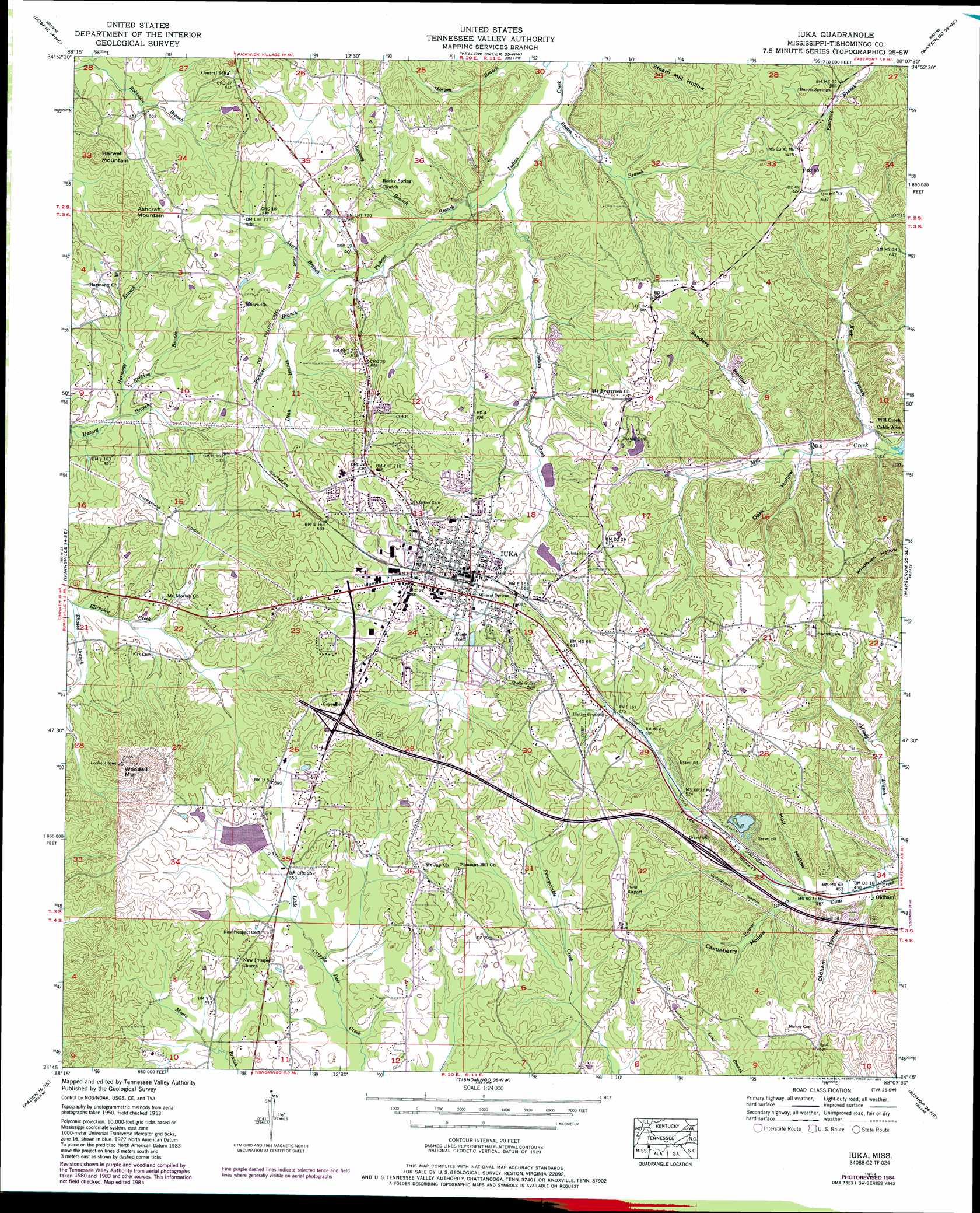
Iuka Topo Map Mississippi
To zoom in, hover over the map of Iuka
USGS Topo Quad 34088g2 - 1:24,000 scale
| Topo Map Name: | Iuka |
| USGS Topo Quad ID: | 34088g2 |
| Print Size: | ca. 21 1/4" wide x 27" high |
| Southeast Coordinates: | 34.75° N latitude / 88.125° W longitude |
| Map Center Coordinates: | 34.8125° N latitude / 88.1875° W longitude |
| U.S. State: | MS |
| Filename: | o34088g2.jpg |
| Download Map JPG Image: | Iuka topo map 1:24,000 scale |
| Map Type: | Topographic |
| Topo Series: | 7.5´ |
| Map Scale: | 1:24,000 |
| Source of Map Images: | United States Geological Survey (USGS) |
| Alternate Map Versions: |
Iuka MS 1935 Download PDF Buy paper map Iuka MS 1953, updated 1958 Download PDF Buy paper map Iuka MS 1953, updated 1974 Download PDF Buy paper map Iuka MS 1953, updated 1985 Download PDF Buy paper map Iuka MS 2012 Download PDF Buy paper map Iuka MS 2015 Download PDF Buy paper map |
1:24,000 Topo Quads surrounding Iuka
Michie |
Counce |
Pickwick |
Lowryville |
Ransom Stand |
Kendrick |
Doskie |
Yellow Creek |
Waterloo |
Wright |
Glens |
Burnsville |
Iuka |
Margerum |
Cherokee |
Altitude |
Paden |
Tishomingo |
Bishop |
Barton |
Marietta |
Paden Se |
Belmont |
Pleasant Site |
Pleasant Grove |
> Back to 34088e1 at 1:100,000 scale
> Back to 34088a1 at 1:250,000 scale
> Back to U.S. Topo Maps home
Iuka topo map: Gazetteer
Iuka: Airports
Iuka Airport elevation 183m 600′Segars Airport elevation 177m 580′
Iuka: Dams
Brinkley Lake Dam elevation 182m 597′Iuka Sewage Lagoon Dam elevation 164m 538′
Iuka: Parks
Mineral Springs Park elevation 161m 528′Iuka: Populated Places
Bacon Springs elevation 165m 541′Blythe Crossing elevation 179m 587′
Iuka elevation 171m 561′
Oldham elevation 135m 442′
Pinedale elevation 176m 577′
Iuka: Reservoirs
Como Lake (historical) elevation 157m 515′Moser Pond elevation 162m 531′
Iuka: Streams
Akers Branch elevation 153m 501′Brown Branch elevation 134m 439′
Dean Branch elevation 158m 518′
Harmony Branch elevation 146m 479′
Kirk Branch elevation 125m 410′
Pickens Branch elevation 137m 449′
Ramsey Branch elevation 143m 469′
Rhodes Branch elevation 144m 472′
Robbins Branch elevation 147m 482′
Rowin Branch elevation 139m 456′
Iuka: Summits
Ashcraft Mountain elevation 202m 662′Harwell Mountain elevation 213m 698′
Woodall Mountain elevation 245m 803′
Iuka: Valleys
Castleberry Hollow elevation 142m 465′Dark Hollow elevation 133m 436′
Holt Hollow elevation 140m 459′
Oldham Hollow elevation 150m 492′
Sanders Hollow elevation 137m 449′
Iuka digital topo map on disk
Buy this Iuka topo map showing relief, roads, GPS coordinates and other geographical features, as a high-resolution digital map file on DVD: