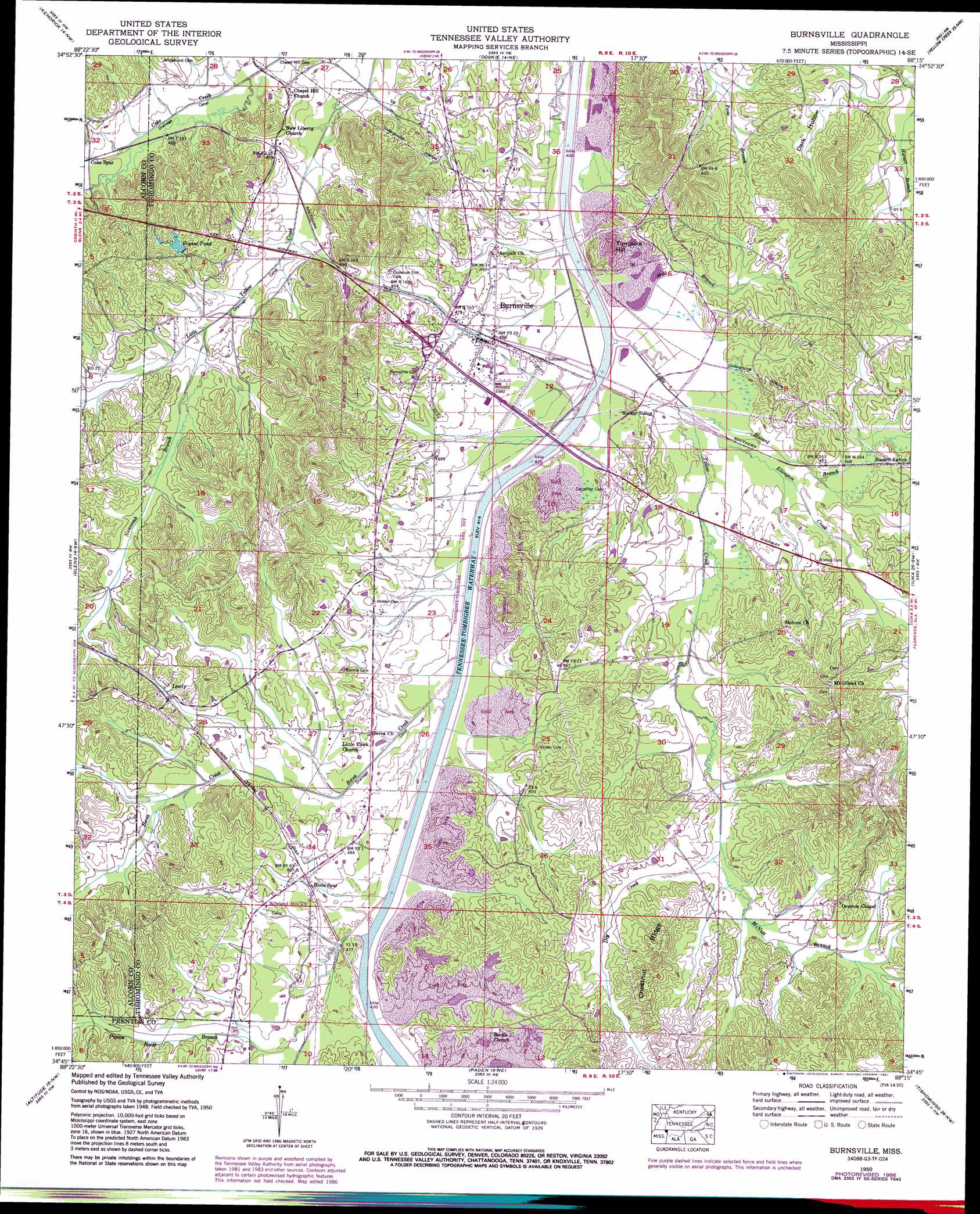
Burnsville Topo Map Mississippi
To zoom in, hover over the map of Burnsville
USGS Topo Quad 34088g3 - 1:24,000 scale
| Topo Map Name: | Burnsville |
| USGS Topo Quad ID: | 34088g3 |
| Print Size: | ca. 21 1/4" wide x 27" high |
| Southeast Coordinates: | 34.75° N latitude / 88.25° W longitude |
| Map Center Coordinates: | 34.8125° N latitude / 88.3125° W longitude |
| U.S. State: | MS |
| Filename: | o34088g3.jpg |
| Download Map JPG Image: | Burnsville topo map 1:24,000 scale |
| Map Type: | Topographic |
| Topo Series: | 7.5´ |
| Map Scale: | 1:24,000 |
| Source of Map Images: | United States Geological Survey (USGS) |
| Alternate Map Versions: |
Leedy MS 1935 Download PDF Buy paper map Burnsville MS 1950, updated 1954 Download PDF Buy paper map Burnsville MS 1950, updated 1971 Download PDF Buy paper map Burnsville MS 1950, updated 1987 Download PDF Buy paper map Burnsville MS 2012 Download PDF Buy paper map Burnsville MS 2015 Download PDF Buy paper map |
1:24,000 Topo Quads surrounding Burnsville
Guys |
Michie |
Counce |
Pickwick |
Lowryville |
Corinth |
Kendrick |
Doskie |
Yellow Creek |
Waterloo |
Rienzi |
Glens |
Burnsville |
Iuka |
Margerum |
Booneville |
Altitude |
Paden |
Tishomingo |
Bishop |
Wheeler |
Marietta |
Paden Se |
Belmont |
Pleasant Site |
> Back to 34088e1 at 1:100,000 scale
> Back to 34088a1 at 1:250,000 scale
> Back to U.S. Topo Maps home
Burnsville topo map: Gazetteer
Burnsville: Canals
Coke Creek Drainage Ditch elevation 135m 442′Marlow Creek Drainage Ditch elevation 140m 459′
Yellow Creek Drainage Ditch (historical) elevation 132m 433′
Burnsville: Parks
Burnsville Overlook Area elevation 144m 472′Burnsville: Populated Places
Burnsville elevation 141m 462′Leedy elevation 147m 482′
Walker Siding elevation 139m 456′
Burnsville: Reservoirs
Bryant Pond elevation 152m 498′Burnsville: Ridges
Chestnut Ridge elevation 185m 606′Tucker Ridge elevation 199m 652′
Burnsville: Streams
Berea Creek elevation 124m 406′Blasingame Creek elevation 141m 462′
Dry Creek elevation 144m 472′
Ellington Creek elevation 135m 442′
Harvell Branch elevation 144m 472′
Hazard Branch elevation 137m 449′
Hines Branch elevation 139m 456′
Little Yellow Creek elevation 134m 439′
McNutt Branch elevation 148m 485′
Mud Branch elevation 134m 439′
Newcomb Branch elevation 140m 459′
Pigeon Roost Branch elevation 142m 465′
Burnsville: Summits
Turnpike Hill elevation 192m 629′Burnsville: Valleys
Dark Hollow elevation 145m 475′Burnsville digital topo map on disk
Buy this Burnsville topo map showing relief, roads, GPS coordinates and other geographical features, as a high-resolution digital map file on DVD: