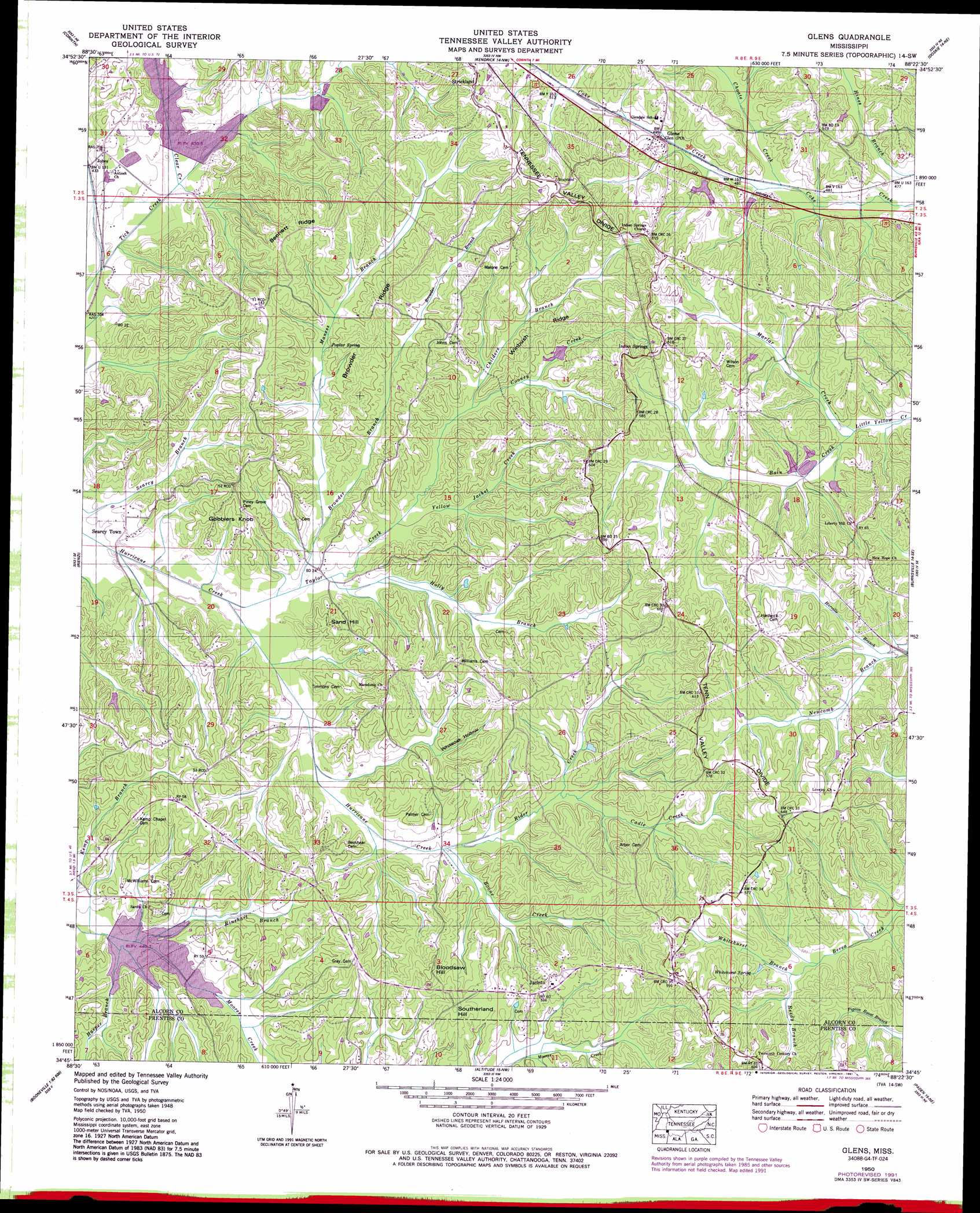
Glens Topo Map Mississippi
To zoom in, hover over the map of Glens
USGS Topo Quad 34088g4 - 1:24,000 scale
| Topo Map Name: | Glens |
| USGS Topo Quad ID: | 34088g4 |
| Print Size: | ca. 21 1/4" wide x 27" high |
| Southeast Coordinates: | 34.75° N latitude / 88.375° W longitude |
| Map Center Coordinates: | 34.8125° N latitude / 88.4375° W longitude |
| U.S. State: | MS |
| Filename: | o34088g4.jpg |
| Download Map JPG Image: | Glens topo map 1:24,000 scale |
| Map Type: | Topographic |
| Topo Series: | 7.5´ |
| Map Scale: | 1:24,000 |
| Source of Map Images: | United States Geological Survey (USGS) |
| Alternate Map Versions: |
Glens MS 1935 Download PDF Buy paper map Glens MS 1950, updated 1954 Download PDF Buy paper map Glens MS 1950, updated 1971 Download PDF Buy paper map Glens MS 1950, updated 1991 Download PDF Buy paper map Glens MS 2012 Download PDF Buy paper map Glens MS 2015 Download PDF Buy paper map |
1:24,000 Topo Quads surrounding Glens
Chewalla |
Guys |
Michie |
Counce |
Pickwick |
Kossuth North |
Corinth |
Kendrick |
Doskie |
Yellow Creek |
Kossuth South |
Rienzi |
Glens |
Burnsville |
Iuka |
Jumpertown |
Booneville |
Altitude |
Paden |
Tishomingo |
Baldwyn |
Wheeler |
Marietta |
Paden Se |
Belmont |
> Back to 34088e1 at 1:100,000 scale
> Back to 34088a1 at 1:250,000 scale
> Back to U.S. Topo Maps home
Glens topo map: Gazetteer
Glens: Dams
Houston Farris Pond Dam elevation 158m 518′Howard Little Pond Dam elevation 153m 501′
Little Lake Dam elevation 148m 485′
Tuscumbia Watershed Structure 8 Dam elevation 130m 426′
Wilbanks Lake Dam elevation 132m 433′
Glens: Populated Places
Glens elevation 153m 501′Indian Springs elevation 172m 564′
Jacinto elevation 171m 561′
Jobes elevation 131m 429′
Searcy Town elevation 135m 442′
Glens: Post Offices
Glen Post Office elevation 153m 501′Glens: Ridges
Bennett Ridge elevation 170m 557′Browder Ridge elevation 171m 561′
Winbush Ridge elevation 176m 577′
Glens: Springs
Poplar Spring elevation 150m 492′Whitehurst Spring elevation 168m 551′
Glens: Streams
Bain Creek elevation 146m 479′Boone Creek elevation 139m 456′
Browder Branch elevation 130m 426′
Cadle Creek elevation 142m 465′
Childers Branch elevation 138m 452′
Choate Creek elevation 144m 472′
Cooney Creek elevation 138m 452′
Harper Branch elevation 132m 433′
Harville Branch elevation 152m 498′
Holly Branch elevation 131m 429′
Maness Branch elevation 134m 439′
Marlar Creek elevation 146m 479′
Railroad Branch elevation 125m 410′
Reedy Branch elevation 156m 511′
Rider Creek elevation 139m 456′
Rinehart Branch elevation 134m 439′
Taylor Creek elevation 128m 419′
Tick Creek elevation 129m 423′
Whitehurst Branch elevation 160m 524′
Yellow Jacket Creek elevation 134m 439′
Glens: Summits
Bloodsaw Hill elevation 184m 603′Gobblers Knob elevation 159m 521′
Sand Hill elevation 160m 524′
Southerland Hill elevation 176m 577′
Glens: Valleys
White Oak Hollow elevation 142m 465′Glens digital topo map on disk
Buy this Glens topo map showing relief, roads, GPS coordinates and other geographical features, as a high-resolution digital map file on DVD: