Rienzi Topo Map Mississippi
To zoom in, hover over the map of Rienzi
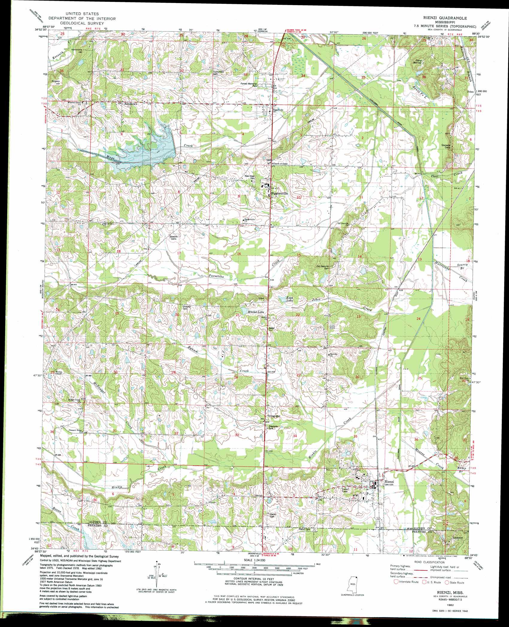
USGS Topo Quad 34088g5 - 1:24,000 scale
| Topo Map Name: | Rienzi |
| USGS Topo Quad ID: | 34088g5 |
| Print Size: | ca. 21 1/4" wide x 27" high |
| Southeast Coordinates: | 34.75° N latitude / 88.5° W longitude |
| Map Center Coordinates: | 34.8125° N latitude / 88.5625° W longitude |
| U.S. State: | MS |
| Filename: | o34088g5.jpg |
| Download Map JPG Image: | Rienzi topo map 1:24,000 scale |
| Map Type: | Topographic |
| Topo Series: | 7.5´ |
| Map Scale: | 1:24,000 |
| Source of Map Images: | United States Geological Survey (USGS) |
| Alternate Map Versions: |
Rienzi MS 1982, updated 1983 Download PDF Buy paper map Rienzi MS 2012 Download PDF Buy paper map Rienzi MS 2015 Download PDF Buy paper map |
1:24,000 Topo Quads surrounding Rienzi
Pocahontas |
Chewalla |
Guys |
Michie |
Counce |
Chalybeate |
Kossuth North |
Corinth |
Kendrick |
Doskie |
Peoples |
Kossuth South |
Rienzi |
Glens |
Burnsville |
Dumas |
Jumpertown |
Booneville |
Altitude |
Paden |
Pleasant Ridge |
Baldwyn |
Wheeler |
Marietta |
Paden Se |
> Back to 34088e1 at 1:100,000 scale
> Back to 34088a1 at 1:250,000 scale
> Back to U.S. Topo Maps home
Rienzi topo map: Gazetteer
Rienzi: Dams
Benjimen Lake Dam elevation 144m 472′J E Powell Pond Dam elevation 150m 492′
Mitchell Lake Dam elevation 150m 492′
Moss Lake Dam elevation 132m 433′
Mrs Curtis Brawner Pond Dam elevation 135m 442′
Tuscumbia Watershed Structure 24 Dam elevation 150m 492′
Rienzi: Lakes
Santa Fe Lake elevation 126m 413′Rienzi: Populated Places
Allentown elevation 153m 501′Biggersville elevation 137m 449′
Rienzi elevation 132m 433′
Synagogue elevation 138m 452′
Rienzi: Post Offices
Mitchells Store Post Office (historical) elevation 142m 465′Rienzi: Reservoirs
Dees Pond elevation 130m 426′Epps Lake elevation 143m 469′
Mitchel Lake elevation 147m 482′
Rienzi: Streams
Bynum Creek elevation 128m 419′Clear Creek elevation 124m 406′
Hinkle Creek elevation 125m 410′
Hurricane Creek elevation 126m 413′
Jobes Creek elevation 125m 410′
Kemp Branch elevation 131m 429′
Mays Creek elevation 124m 406′
McDougal Creek elevation 135m 442′
Moores Creek elevation 126m 413′
Parmicha Creek elevation 123m 403′
Searcy Branch elevation 126m 413′
Rienzi: Summits
Kimmons Hill elevation 140m 459′Rogers Hill elevation 156m 511′
Rienzi digital topo map on disk
Buy this Rienzi topo map showing relief, roads, GPS coordinates and other geographical features, as a high-resolution digital map file on DVD: