Falkner Topo Map Mississippi
To zoom in, hover over the map of Falkner
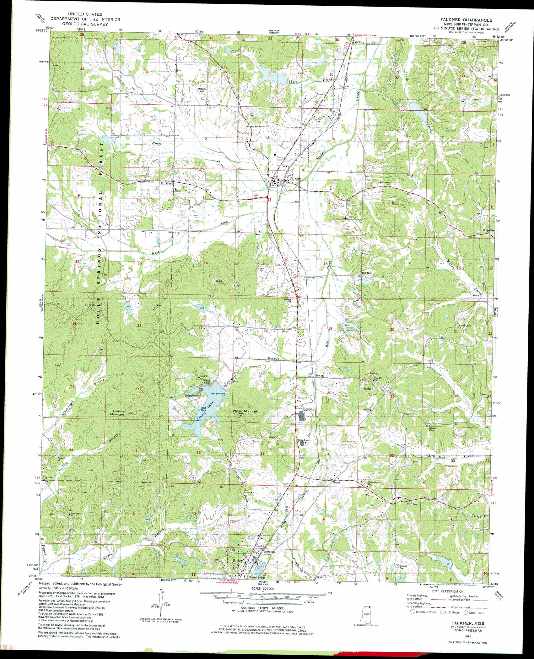
USGS Topo Quad 34088g8 - 1:24,000 scale
| Topo Map Name: | Falkner |
| USGS Topo Quad ID: | 34088g8 |
| Print Size: | ca. 21 1/4" wide x 27" high |
| Southeast Coordinates: | 34.75° N latitude / 88.875° W longitude |
| Map Center Coordinates: | 34.8125° N latitude / 88.9375° W longitude |
| U.S. State: | MS |
| Filename: | o34088g8.jpg |
| Download Map JPG Image: | Falkner topo map 1:24,000 scale |
| Map Type: | Topographic |
| Topo Series: | 7.5´ |
| Map Scale: | 1:24,000 |
| Source of Map Images: | United States Geological Survey (USGS) |
| Alternate Map Versions: |
Falkner MS 1982, updated 1983 Download PDF Buy paper map Falkner MS 2000, updated 2003 Download PDF Buy paper map Falkner MS 2012 Download PDF Buy paper map Falkner MS 2015 Download PDF Buy paper map |
| FStopo: | US Forest Service topo Falkner is available: Download FStopo PDF Download FStopo TIF |
1:24,000 Topo Quads surrounding Falkner
Grand Junction |
Saulsbury |
Middleton |
Pocahontas |
Chewalla |
Canaan |
Camp Hill |
Walnut |
Chalybeate |
Kossuth North |
Ashland |
Whitten Town |
Falkner |
Peoples |
Kossuth South |
Chilli Creek |
Blue Mountain |
Ripley |
Dumas |
Jumpertown |
Hickory Flat |
Myrtle |
Keownville |
Pleasant Ridge |
Baldwyn |
> Back to 34088e1 at 1:100,000 scale
> Back to 34088a1 at 1:250,000 scale
> Back to U.S. Topo Maps home
Falkner topo map: Gazetteer
Falkner: Dams
B D Cox Pond Dam elevation 178m 583′Muddy Creek Number 36 Dam elevation 144m 472′
Muddy Creek Structure 2 Dam elevation 160m 524′
Muddy Creek Watershed Structure 1 Dam elevation 157m 515′
Muddy Creek Watershed Structure 10A Dam elevation 163m 534′
Muddy Creek Watershed Structure 23 Dam elevation 146m 479′
Muddy Creek Watershed Structure 26 Dam elevation 146m 479′
Muddy Creek Watershed Structure 5 Dam elevation 153m 501′
Muddy Creek Watershed Structure 9 Dam elevation 143m 469′
T Caffey Robertson Pond Dam elevation 152m 498′
West Hatchie Watershed 9 Dam elevation 150m 492′
Falkner: Populated Places
Falkner elevation 141m 462′Mount Zion elevation 164m 538′
Walnut Creek elevation 175m 574′
Falkner: Reservoirs
County Lake elevation 158m 518′Tippah County State Fishing Lake elevation 158m 518′
Falkner: Streams
Bell Creek elevation 135m 442′Bowling Branch elevation 132m 433′
Fourmile Branch elevation 141m 462′
Linebarger Branch elevation 136m 446′
Medlock Branch elevation 128m 419′
North Prong Muddy Creek elevation 135m 442′
Short Creek elevation 131m 429′
Turkey Creek elevation 130m 426′
West Prong Muddy Creek elevation 138m 452′
Falkner: Summits
Lindsey Mountain elevation 213m 698′Wicker Mountain elevation 224m 734′
Falkner digital topo map on disk
Buy this Falkner topo map showing relief, roads, GPS coordinates and other geographical features, as a high-resolution digital map file on DVD: