Yellow Creek Topo Map Mississippi
To zoom in, hover over the map of Yellow Creek
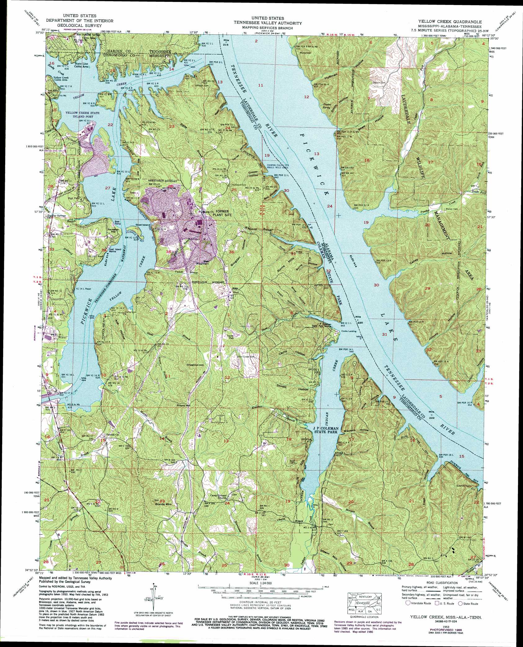
USGS Topo Quad 34088h2 - 1:24,000 scale
| Topo Map Name: | Yellow Creek |
| USGS Topo Quad ID: | 34088h2 |
| Print Size: | ca. 21 1/4" wide x 27" high |
| Southeast Coordinates: | 34.875° N latitude / 88.125° W longitude |
| Map Center Coordinates: | 34.9375° N latitude / 88.1875° W longitude |
| U.S. States: | MS, AL, TN |
| Filename: | o34088h2.jpg |
| Download Map JPG Image: | Yellow Creek topo map 1:24,000 scale |
| Map Type: | Topographic |
| Topo Series: | 7.5´ |
| Map Scale: | 1:24,000 |
| Source of Map Images: | United States Geological Survey (USGS) |
| Alternate Map Versions: |
Shaws MS 1936 Download PDF Buy paper map Yellow Creek MS 1953, updated 1958 Download PDF Buy paper map Yellow Creek MS 1953, updated 1971 Download PDF Buy paper map Yellow Creek MS 1953, updated 1977 Download PDF Buy paper map Yellow Creek MS 1953, updated 1984 Download PDF Buy paper map Yellow Creek MS 1953, updated 1987 Download PDF Buy paper map Yellow Creek MS 1953, updated 1987 Download PDF Buy paper map Yellow Creek MS 2010 Download PDF Buy paper map Yellow Creek MS 2012 Download PDF Buy paper map Yellow Creek MS 2015 Download PDF Buy paper map |
1:24,000 Topo Quads surrounding Yellow Creek
Stantonville |
Pittsburg Landing |
Savannah |
Wolf Pit Ridge |
Martins Mills |
Michie |
Counce |
Pickwick |
Lowryville |
Ransom Stand |
Kendrick |
Doskie |
Yellow Creek |
Waterloo |
Wright |
Glens |
Burnsville |
Iuka |
Margerum |
Cherokee |
Altitude |
Paden |
Tishomingo |
Bishop |
Barton |
> Back to 34088e1 at 1:100,000 scale
> Back to 34088a1 at 1:250,000 scale
> Back to U.S. Topo Maps home
Yellow Creek topo map: Gazetteer
Yellow Creek: Bridges
Ferry Bridge (historical) elevation 124m 406′Yellow Creek: Crossings
State Line Ferry (historical) elevation 126m 413′Yellow Creek: Islands
Goat Island elevation 137m 449′State Line Island elevation 126m 413′
Yellow Creek: Parks
Goat Island Recreation Area elevation 134m 439′J P Coleman State Park elevation 171m 561′
Lauderdale State Wildlife Management Area elevation 182m 597′
Scruggs Bridge Overlook Area elevation 129m 423′
Yellow Creek: Populated Places
Cooks Landing elevation 136m 446′Haddock (historical) elevation 189m 620′
High Point elevation 154m 505′
Shaw (historical) elevation 145m 475′
Short elevation 189m 620′
Yellow Creek: Post Offices
Haddock Post Office (historical) elevation 189m 620′Yellow Creek: Springs
Poplar Spring elevation 126m 413′Yellow Creek: Streams
Arnold Branch elevation 124m 406′Baugh Creek elevation 126m 413′
Bullard Branch elevation 129m 423′
Camp Hollow Creek elevation 124m 406′
Cedar Fork elevation 129m 423′
Charlie Branch elevation 124m 406′
Glade Branch elevation 124m 406′
Hitchcock Branch elevation 126m 413′
Hubbard Branch elevation 124m 406′
Huffman Branch elevation 126m 413′
Hurricane Branch elevation 131m 429′
Indian Creek elevation 124m 406′
Johnny Creek elevation 126m 413′
Kreamer Branch elevation 124m 406′
Lard Branch elevation 124m 406′
Martin Branch elevation 126m 413′
Morgan Branch elevation 134m 439′
Morgan Branch elevation 126m 413′
North Fork Panther Creek elevation 135m 442′
Panther Creek elevation 126m 413′
Red Sulphur Springs Branch elevation 124m 406′
Sandy Creek elevation 124m 406′
Sandy Creek elevation 124m 406′
Scruggs Branch elevation 127m 416′
Shaw Branch elevation 126m 413′
Short Creek elevation 124m 406′
Slick Rock Branch elevation 124m 406′
Smith Branch elevation 124m 406′
South Fork Panther Creek elevation 135m 442′
Tackett Branch elevation 128m 419′
Tanyard Branch elevation 124m 406′
Whetstone Branch elevation 124m 406′
Yellow Creek elevation 126m 413′
Zippy Branch elevation 124m 406′
Yellow Creek: Summits
Bee Mountain elevation 186m 610′Bonds Mountain elevation 219m 718′
Burns Hills elevation 177m 580′
Chestnut Hill elevation 205m 672′
Middle Mountain elevation 210m 688′
Potato Hill elevation 209m 685′
Yellow Creek: Valleys
Ada Hollow elevation 124m 406′Blackard Hollow elevation 124m 406′
Boo Hollow elevation 149m 488′
Brogdan Hollow elevation 165m 541′
Burns Hollow elevation 123m 403′
Camp Hollow elevation 124m 406′
Caney Hollow elevation 126m 413′
Caney Hollow elevation 168m 551′
Chalk Hollow elevation 124m 406′
Cooper Hollow elevation 123m 403′
Dixon Hollow elevation 136m 446′
Fred Hollow elevation 124m 406′
Hicks Hollow elevation 124m 406′
Hitchcock Hollow elevation 126m 413′
Huffman Hollow elevation 126m 413′
Johnny Hollow elevation 126m 413′
Meat Hollow elevation 147m 482′
Owens Hollow elevation 126m 413′
Shaw Hollow elevation 126m 413′
Shop Hollow elevation 134m 439′
Smith Hollow elevation 126m 413′
Steam Mill Hollow elevation 132m 433′
Stinett Hollow elevation 124m 406′
Union Hollow elevation 126m 413′
Yellow Creek digital topo map on disk
Buy this Yellow Creek topo map showing relief, roads, GPS coordinates and other geographical features, as a high-resolution digital map file on DVD: