Doskie Topo Map Mississippi
To zoom in, hover over the map of Doskie
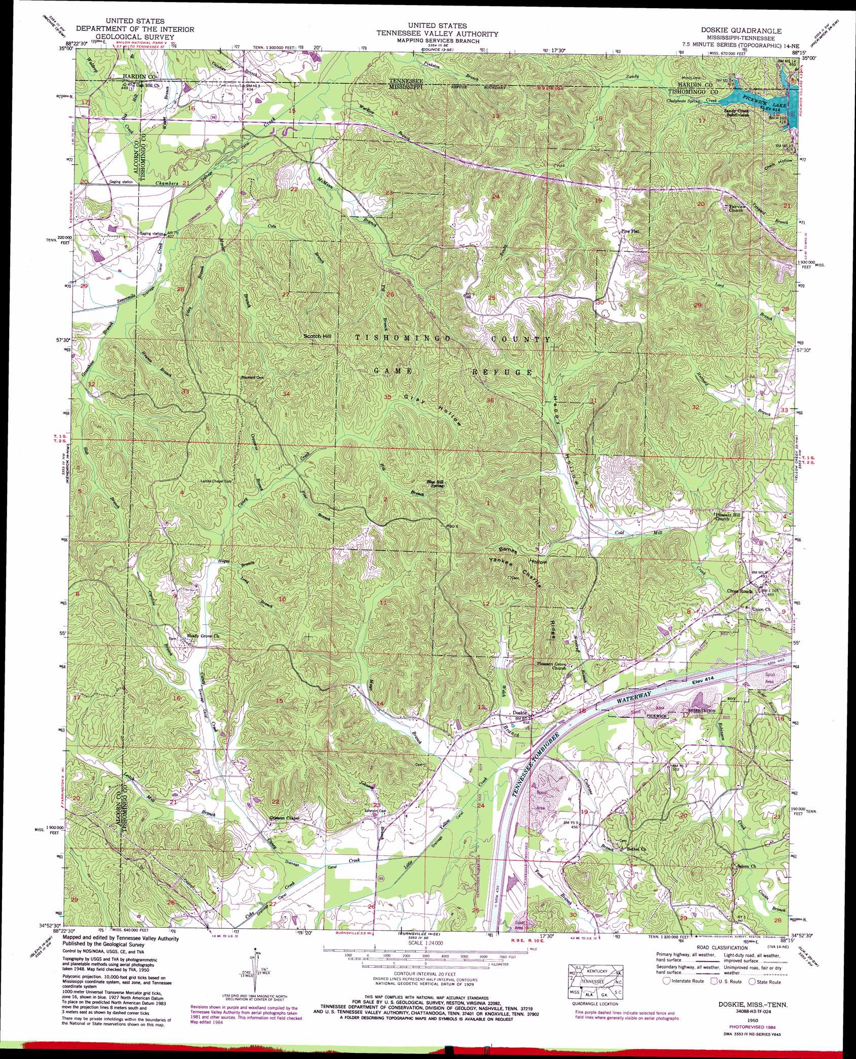
USGS Topo Quad 34088h3 - 1:24,000 scale
| Topo Map Name: | Doskie |
| USGS Topo Quad ID: | 34088h3 |
| Print Size: | ca. 21 1/4" wide x 27" high |
| Southeast Coordinates: | 34.875° N latitude / 88.25° W longitude |
| Map Center Coordinates: | 34.9375° N latitude / 88.3125° W longitude |
| U.S. States: | MS, TN |
| Filename: | o34088h3.jpg |
| Download Map JPG Image: | Doskie topo map 1:24,000 scale |
| Map Type: | Topographic |
| Topo Series: | 7.5´ |
| Map Scale: | 1:24,000 |
| Source of Map Images: | United States Geological Survey (USGS) |
| Alternate Map Versions: |
Doskie MS 1935 Download PDF Buy paper map Doskie MS 1950, updated 1954 Download PDF Buy paper map Doskie MS 1950, updated 1971 Download PDF Buy paper map Doskie MS 1950, updated 1986 Download PDF Buy paper map Doskie MS 2010 Download PDF Buy paper map Doskie MS 2012 Download PDF Buy paper map Doskie MS 2015 Download PDF Buy paper map |
1:24,000 Topo Quads surrounding Doskie
Purdy |
Stantonville |
Pittsburg Landing |
Savannah |
Wolf Pit Ridge |
Guys |
Michie |
Counce |
Pickwick |
Lowryville |
Corinth |
Kendrick |
Doskie |
Yellow Creek |
Waterloo |
Rienzi |
Glens |
Burnsville |
Iuka |
Margerum |
Booneville |
Altitude |
Paden |
Tishomingo |
Bishop |
> Back to 34088e1 at 1:100,000 scale
> Back to 34088a1 at 1:250,000 scale
> Back to U.S. Topo Maps home
Doskie topo map: Gazetteer
Doskie: Bridges
Moser Bridge elevation 124m 406′Sharp Bridge elevation 120m 393′
Doskie: Canals
Caney Creek Drainage Ditch elevation 137m 449′Chamber Creek Drainage Ditch elevation 122m 400′
Doskie: Lakes
Beaver Pond (historical) elevation 123m 403′Doskie: Parks
Tishomingo County Game Refuge elevation 200m 656′Doskie: Populated Places
Cross Roads elevation 149m 488′Doskie elevation 139m 456′
Pine Flat elevation 208m 682′
Sandy Creek Subdivision elevation 140m 459′
Doskie: Ridges
Yankee Charlie Ridge elevation 185m 606′Doskie: Springs
Blue Bill Spring elevation 194m 636′Chalybeate Spring elevation 126m 413′
Doskie: Streams
Calahan Branch elevation 120m 393′Calahan Branch elevation 119m 390′
Caney Creek elevation 131m 429′
Caroline Branch elevation 140m 459′
Cochrane Branch elevation 124m 406′
Coke Creek elevation 132m 433′
Cold Mill Creek elevation 126m 413′
Coln Branch elevation 121m 396′
Copperas Branch elevation 149m 488′
Counts Branch elevation 142m 465′
Foote Branch elevation 124m 406′
Greenhaw Branch elevation 123m 403′
Haynes Branch elevation 122m 400′
Hill Branch elevation 155m 508′
Hogue Branch elevation 144m 472′
Johnson Branch elevation 131m 429′
Leitch Mill Branch elevation 134m 439′
Little Yellow Creek elevation 124m 406′
Long Branch elevation 146m 479′
Marlar Branch elevation 122m 400′
Mayo Branch elevation 129m 423′
McMinn Branch elevation 117m 383′
Moser Branch elevation 126m 413′
Oak Hill Branch elevation 123m 403′
Oak Hill Branch elevation 123m 403′
Pig Branch elevation 133m 436′
Pine Branch elevation 150m 492′
Robinson Creek elevation 123m 403′
Sevenmile Creek elevation 120m 393′
Sevenmile Creek elevation 120m 393′
Slab Branch elevation 127m 416′
Utley Branch elevation 125m 410′
Waldrop Creek elevation 122m 400′
Waldrop Creek elevation 122m 400′
Wardlow Branch elevation 117m 383′
Wayne Branch elevation 122m 400′
Wayne Branch elevation 122m 400′
Welch Branch elevation 124m 406′
Woodruff Branch elevation 127m 416′
Doskie: Summits
Scotch Hill elevation 207m 679′Doskie: Valleys
Barnes Hollow elevation 140m 459′Gray Hollow elevation 155m 508′
Happy Hollow elevation 140m 459′
Doskie digital topo map on disk
Buy this Doskie topo map showing relief, roads, GPS coordinates and other geographical features, as a high-resolution digital map file on DVD: