Oakland Topo Map Mississippi
To zoom in, hover over the map of Oakland
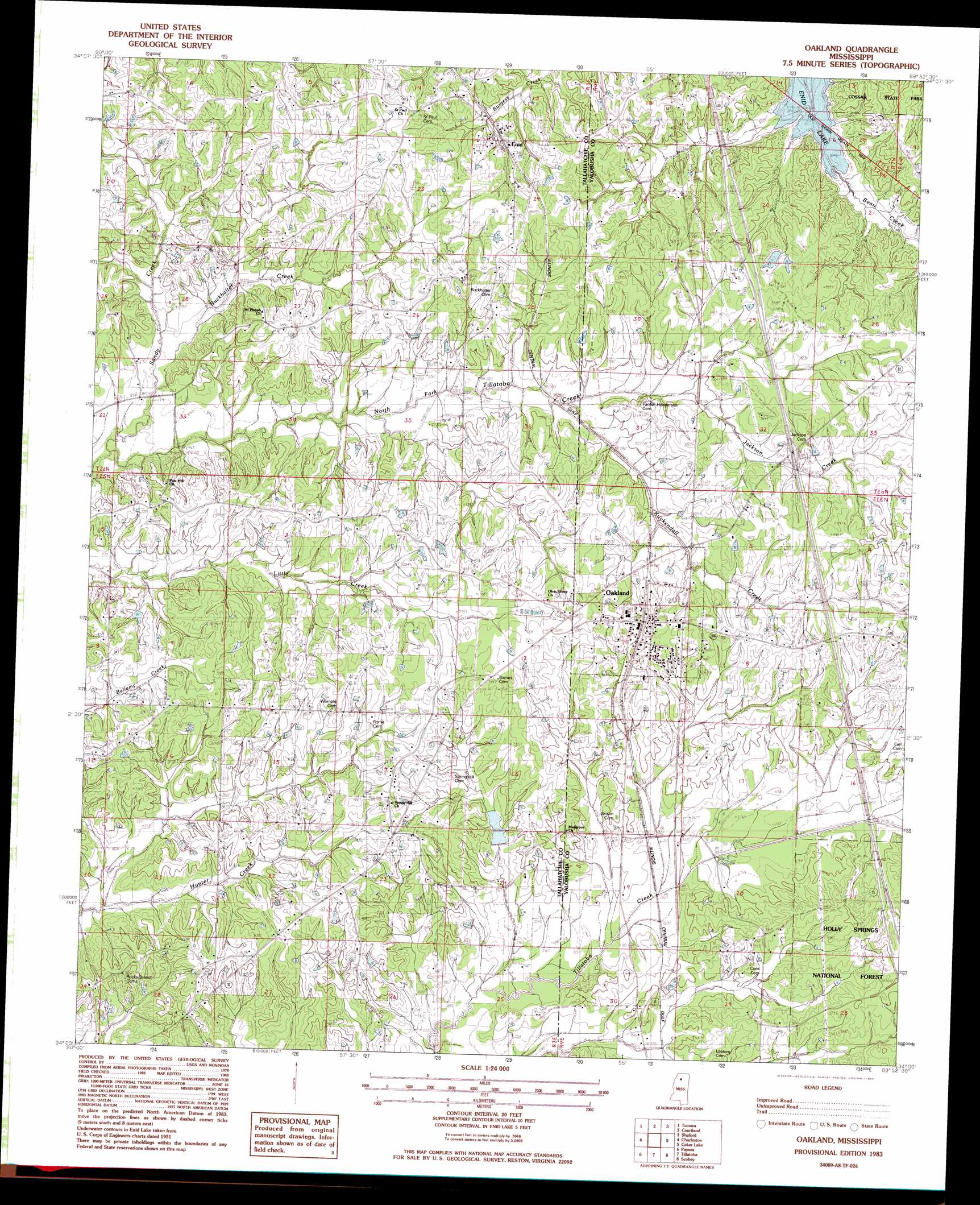
USGS Topo Quad 34089a8 - 1:24,000 scale
| Topo Map Name: | Oakland |
| USGS Topo Quad ID: | 34089a8 |
| Print Size: | ca. 21 1/4" wide x 27" high |
| Southeast Coordinates: | 34° N latitude / 89.875° W longitude |
| Map Center Coordinates: | 34.0625° N latitude / 89.9375° W longitude |
| U.S. State: | MS |
| Filename: | o34089a8.jpg |
| Download Map JPG Image: | Oakland topo map 1:24,000 scale |
| Map Type: | Topographic |
| Topo Series: | 7.5´ |
| Map Scale: | 1:24,000 |
| Source of Map Images: | United States Geological Survey (USGS) |
| Alternate Map Versions: |
Oakland MS 1983, updated 1983 Download PDF Buy paper map Oakland MS 2000, updated 2003 Download PDF Buy paper map Oakland MS 2012 Download PDF Buy paper map Oakland MS 2015 Download PDF Buy paper map |
| FStopo: | US Forest Service topo Oakland is available: Download FStopo PDF Download FStopo TIF |
1:24,000 Topo Quads surrounding Oakland
Curtis Station |
Asa |
Batesville |
Sardis Se |
Splinter |
Crowder |
Tocowa |
Courtland |
Shuford |
Water Valley West |
Fishhook Lake |
Charleston |
Oakland |
Coker Lake |
Velma |
Tippo |
Paynes |
Tillatoba |
Scobey |
Coffeeville |
Philipp |
Cascilla |
Holcomb |
Grenada |
Kincaid |
> Back to 34089a1 at 1:100,000 scale
> Back to 34088a1 at 1:250,000 scale
> Back to U.S. Topo Maps home
Oakland topo map: Gazetteer
Oakland: Crossings
Interchange 227 elevation 104m 341′Oakland: Dams
House Lake Dam elevation 103m 337′Tillatoba Creek Y-17b-17 Dam elevation 103m 337′
Tillatoba Creek Y-17b-7 Dam elevation 84m 275′
Oakland: Populated Places
Center Point (historical) elevation 101m 331′Enid elevation 94m 308′
Oakland elevation 107m 351′
Oakland: Streams
Burkhalter Creek elevation 73m 239′Jackson Creek elevation 87m 285′
Kuykendall Creek elevation 82m 269′
Sandy Creek elevation 70m 229′
Oakland digital topo map on disk
Buy this Oakland topo map showing relief, roads, GPS coordinates and other geographical features, as a high-resolution digital map file on DVD: