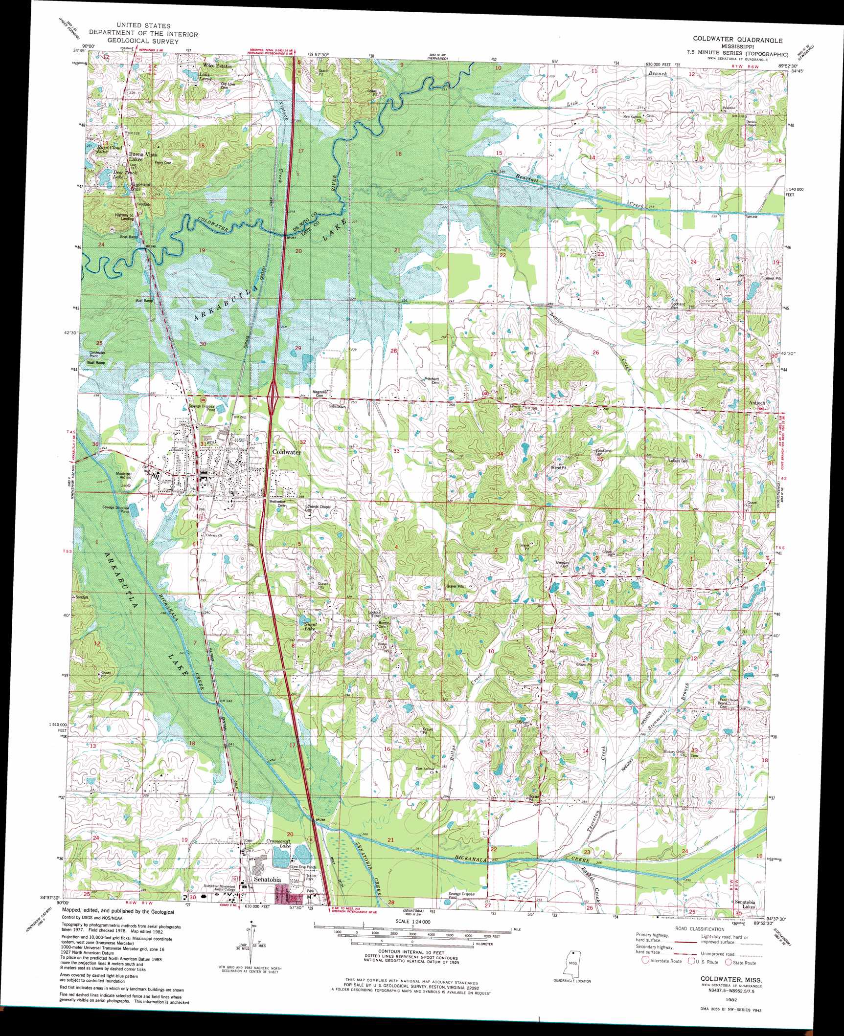
Coldwater Topo Map Mississippi
To zoom in, hover over the map of Coldwater
USGS Topo Quad 34089f8 - 1:24,000 scale
| Topo Map Name: | Coldwater |
| USGS Topo Quad ID: | 34089f8 |
| Print Size: | ca. 21 1/4" wide x 27" high |
| Southeast Coordinates: | 34.625° N latitude / 89.875° W longitude |
| Map Center Coordinates: | 34.6875° N latitude / 89.9375° W longitude |
| U.S. State: | MS |
| Filename: | o34089f8.jpg |
| Download Map JPG Image: | Coldwater topo map 1:24,000 scale |
| Map Type: | Topographic |
| Topo Series: | 7.5´ |
| Map Scale: | 1:24,000 |
| Source of Map Images: | United States Geological Survey (USGS) |
| Alternate Map Versions: |
Senatobia NW MS 1975, updated 1976 Download PDF Buy paper map Coldwater MS 1982, updated 1982 Download PDF Buy paper map Coldwater MS 2012 Download PDF Buy paper map Coldwater MS 2015 Download PDF Buy paper map |
1:24,000 Topo Quads surrounding Coldwater
Lake Cormorant |
Horn Lake |
Pleasant Hill |
Olive Branch |
Byhalia Nw |
Banks |
Frees Corners |
Hernando |
Lewisburg |
Byhalia |
Arkabutla West |
Arkabutla East |
Coldwater |
Independence |
Wyatte |
Crenshaw North |
Longtown |
Senatobia |
Looxahoma |
Tyro |
Crenshaw South |
Pleasant Grove |
Sardis |
Sardis Dam |
Coles Point |
> Back to 34089e1 at 1:100,000 scale
> Back to 34088a1 at 1:250,000 scale
> Back to U.S. Topo Maps home
Coldwater topo map: Gazetteer
Coldwater: Airports
Coldwater Airport elevation 76m 249′Coldwater: Crossings
Interchange 271 elevation 77m 252′Coldwater: Dams
Buena Vista Lake Dam elevation 101m 331′Coldwater Lagoon Dam elevation 75m 246′
David E Jones Pond Dam elevation 89m 291′
Edwin Scott Pond Dam elevation 92m 301′
Mrs T P Wilson Pond Dam elevation 92m 301′
Senatobia Lakes Incorporated Pond Dam elevation 82m 269′
Coldwater: Parks
Coldwater Point Public Use Area elevation 68m 223′Coldwater: Populated Places
Coldwater elevation 76m 249′Wilco Estates elevation 98m 321′
Coldwater: Reservoirs
Cromecraft Lake elevation 73m 239′Deer Track Lake elevation 93m 305′
Lake Larue elevation 92m 301′
Skybrand Lake elevation 86m 282′
Suent Lake elevation 94m 308′
Coldwater: Streams
Basket Creek elevation 75m 246′Beartail Creek elevation 69m 226′
Billys Creek elevation 73m 239′
Senatobia Creek elevation 73m 239′
Steammill Branch elevation 79m 259′
Thornton Creek elevation 75m 246′
Coldwater digital topo map on disk
Buy this Coldwater topo map showing relief, roads, GPS coordinates and other geographical features, as a high-resolution digital map file on DVD: