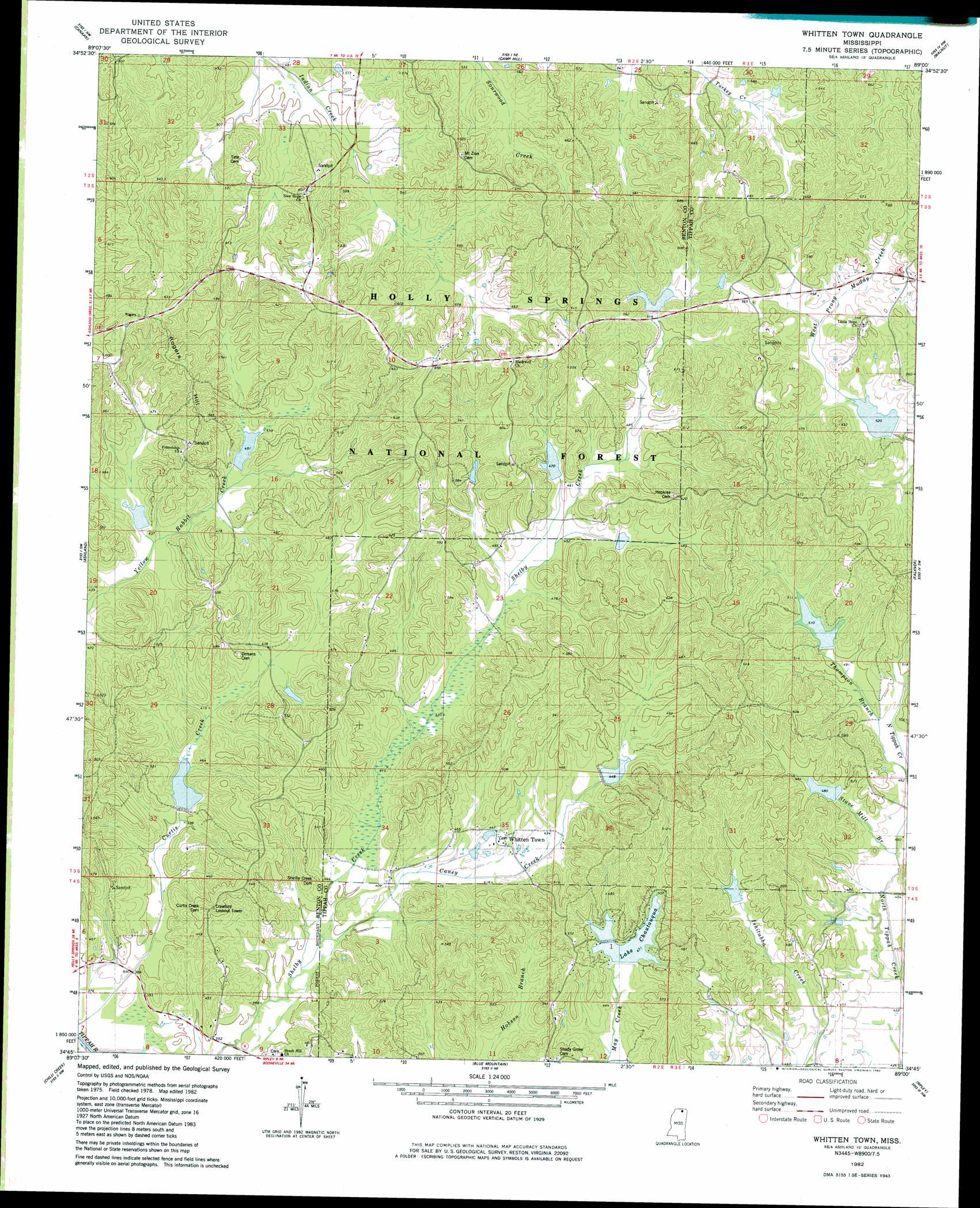
Whitten Town Topo Map Mississippi
To zoom in, hover over the map of Whitten Town
USGS Topo Quad 34089g1 - 1:24,000 scale
| Topo Map Name: | Whitten Town |
| USGS Topo Quad ID: | 34089g1 |
| Print Size: | ca. 21 1/4" wide x 27" high |
| Southeast Coordinates: | 34.75° N latitude / 89° W longitude |
| Map Center Coordinates: | 34.8125° N latitude / 89.0625° W longitude |
| U.S. State: | MS |
| Filename: | o34089g1.jpg |
| Download Map JPG Image: | Whitten Town topo map 1:24,000 scale |
| Map Type: | Topographic |
| Topo Series: | 7.5´ |
| Map Scale: | 1:24,000 |
| Source of Map Images: | United States Geological Survey (USGS) |
| Alternate Map Versions: |
Whitten Town MS 1982, updated 1983 Download PDF Buy paper map Whitten Town MS 2000, updated 2003 Download PDF Buy paper map Whitten Town MS 2012 Download PDF Buy paper map Whitten Town MS 2015 Download PDF Buy paper map |
| FStopo: | US Forest Service topo Whitten Town is available: Download FStopo PDF Download FStopo TIF |
1:24,000 Topo Quads surrounding Whitten Town
Moscow Se |
Grand Junction |
Saulsbury |
Middleton |
Pocahontas |
Lamar |
Canaan |
Camp Hill |
Walnut |
Chalybeate |
Holly Springs Se |
Ashland |
Whitten Town |
Falkner |
Peoples |
Potts Camp |
Chilli Creek |
Blue Mountain |
Ripley |
Dumas |
Bethlehem |
Hickory Flat |
Myrtle |
Keownville |
Pleasant Ridge |
> Back to 34089e1 at 1:100,000 scale
> Back to 34088a1 at 1:250,000 scale
> Back to U.S. Topo Maps home
Whitten Town topo map: Gazetteer
Whitten Town: Dams
Floyd Lake Dam elevation 143m 469′Lake Edwards Dam elevation 135m 442′
Little Tippah River LT-7-17 Dam elevation 170m 557′
LT-5-8 Dam elevation 140m 459′
LT-6-3 Dam elevation 146m 479′
LT-7-6 Dam elevation 121m 396′
Muddy Creek Structure 4 Dam elevation 161m 528′
North Tippah Watershed LT-6a-1 Dam elevation 150m 492′
North Tippah Watershed LT-6a-14 Dam elevation 146m 479′
North Tippah Watershed LT-6a-2 Dam elevation 153m 501′
Upper Tippah Watershed LT-6-1 Dam elevation 173m 567′
Upper Tippah Watershed LT-6-17 Dam elevation 134m 439′
Upper Tippah Watershed LT-6-2 Dam elevation 174m 570′
Upper Tippah Watershed LT-6-4 Dam elevation 179m 587′
Whitten Town: Populated Places
Whitten Town elevation 134m 439′Whitten Town: Reservoirs
Curtis Lake elevation 122m 400′Lake Chautauqua elevation 140m 459′
LT-5-8 Lake elevation 140m 459′
LT-6-3 Lake elevation 146m 479′
LT-7-6 Lake elevation 121m 396′
Shelby Lake elevation 147m 482′
Yellow Rabbit Lake elevation 140m 459′
Whitten Town: Streams
Caney Creek elevation 117m 383′Stave Mill Branch elevation 135m 442′
Thompson Branch elevation 140m 459′
Whitten Town: Summits
Rogers Hill elevation 197m 646′Whitten Town digital topo map on disk
Buy this Whitten Town topo map showing relief, roads, GPS coordinates and other geographical features, as a high-resolution digital map file on DVD: