Fishhook Lake Topo Map Mississippi
To zoom in, hover over the map of Fishhook Lake
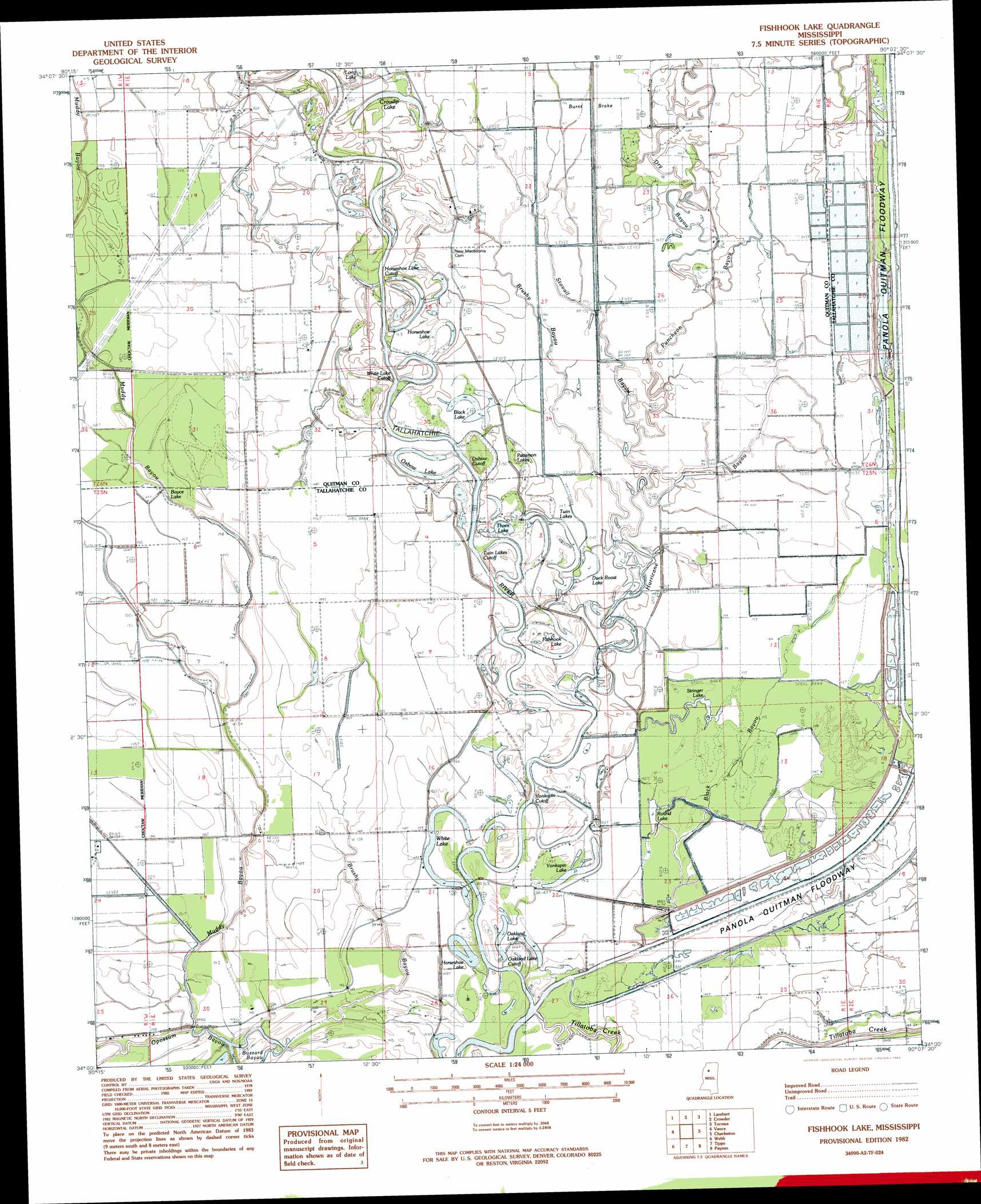
USGS Topo Quad 34090a2 - 1:24,000 scale
| Topo Map Name: | Fishhook Lake |
| USGS Topo Quad ID: | 34090a2 |
| Print Size: | ca. 21 1/4" wide x 27" high |
| Southeast Coordinates: | 34° N latitude / 90.125° W longitude |
| Map Center Coordinates: | 34.0625° N latitude / 90.1875° W longitude |
| U.S. State: | MS |
| Filename: | o34090a2.jpg |
| Download Map JPG Image: | Fishhook Lake topo map 1:24,000 scale |
| Map Type: | Topographic |
| Topo Series: | 7.5´ |
| Map Scale: | 1:24,000 |
| Source of Map Images: | United States Geological Survey (USGS) |
| Alternate Map Versions: |
Fishhook Lake MS 1982, updated 1983 Download PDF Buy paper map Fishhook Lake MS 2012 Download PDF Buy paper map Fishhook Lake MS 2015 Download PDF Buy paper map |
1:24,000 Topo Quads surrounding Fishhook Lake
Jonestown |
Marks |
Curtis Station |
Asa |
Batesville |
Sabino |
Lambert |
Crowder |
Tocowa |
Courtland |
Tutwiler |
Vance |
Fishhook Lake |
Charleston |
Oakland |
Rome |
Webb |
Tippo |
Paynes |
Tillatoba |
Brooks |
Glendora |
Philipp |
Cascilla |
Holcomb |
> Back to 34090a1 at 1:100,000 scale
> Back to 34090a1 at 1:250,000 scale
> Back to U.S. Topo Maps home
Fishhook Lake topo map: Gazetteer
Fishhook Lake: Bends
Horseshoe Lake Cut -Off elevation 45m 147′Oakland Lake Cut -Off elevation 44m 144′
Oxbow Cut -Off elevation 44m 144′
Twin Lakes Cut -Off elevation 44m 144′
White Lake Cut -Off elevation 44m 144′
Fishhook Lake: Lakes
Black Lake elevation 45m 147′Boyce Lake elevation 42m 137′
Croudip Lake elevation 44m 144′
Duck Roost Lake elevation 43m 141′
Fishhook Lake elevation 43m 141′
Horseshoe Lake elevation 43m 141′
Horseshoe Lake elevation 44m 144′
Oakland Lake elevation 44m 144′
Oxbow Lake elevation 46m 150′
Patterson Lakes elevation 45m 147′
Round Lake elevation 43m 141′
Stringer Lake elevation 44m 144′
Thorn Lake elevation 43m 141′
Twin Lake elevation 43m 141′
White Lake elevation 43m 141′
Yonkapin Lake elevation 43m 141′
Fishhook Lake: Streams
Black Bayou elevation 44m 144′Black Bayou elevation 44m 144′
Brushy Bayou elevation 44m 144′
Brushy Bayou elevation 42m 137′
Dry Bayou elevation 44m 144′
Hurricane Bayou elevation 44m 144′
Little Frazier Bayou elevation 45m 147′
Muddy Bayou elevation 42m 137′
Puncheon Bayou elevation 44m 144′
Stovall Bayou elevation 44m 144′
Tillatoba Creek elevation 42m 137′
Fishhook Lake: Swamps
Burnt Brake elevation 44m 144′Fishhook Lake digital topo map on disk
Buy this Fishhook Lake topo map showing relief, roads, GPS coordinates and other geographical features, as a high-resolution digital map file on DVD: