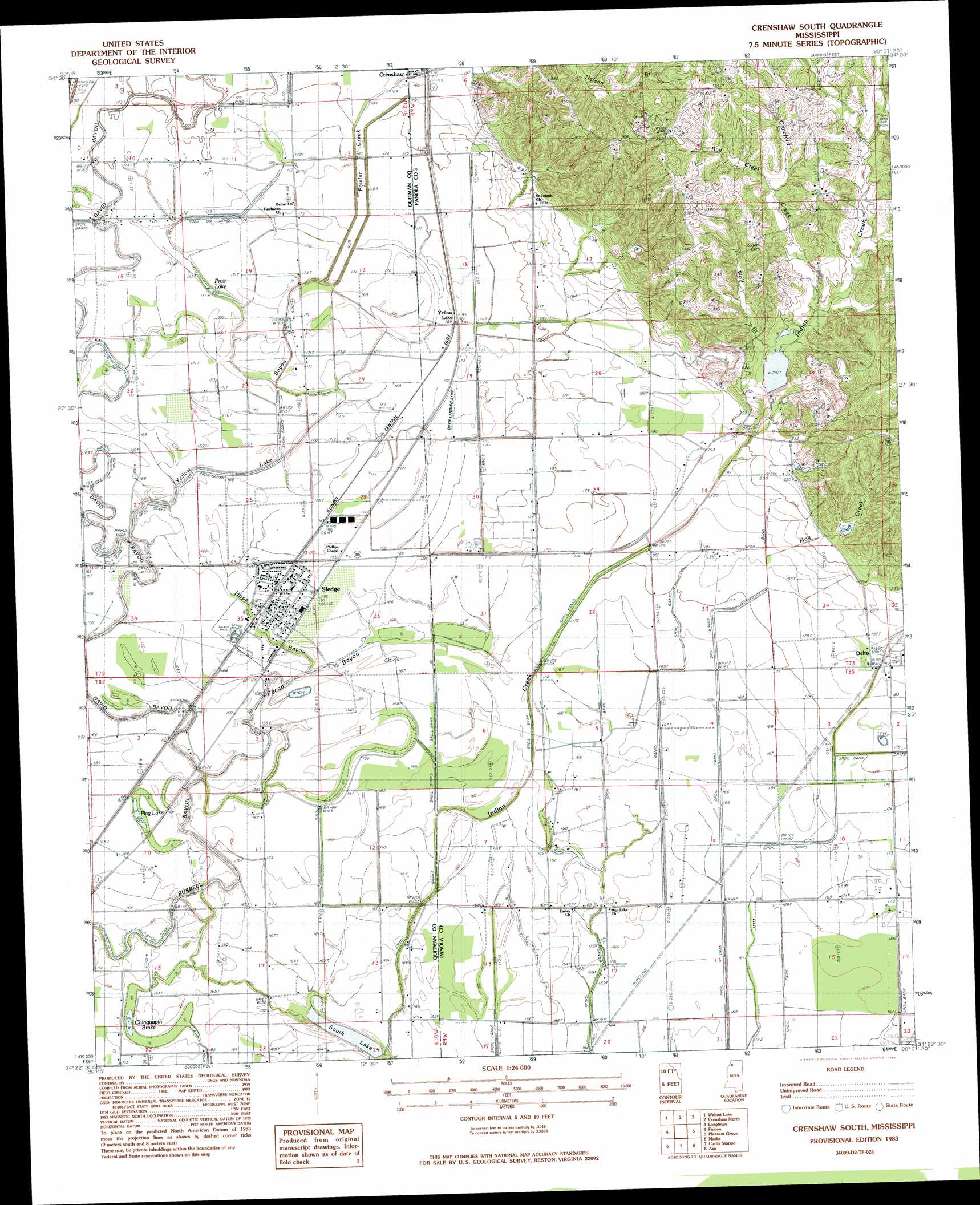
Crenshaw South Topo Map Mississippi
To zoom in, hover over the map of Crenshaw South
USGS Topo Quad 34090d2 - 1:24,000 scale
| Topo Map Name: | Crenshaw South |
| USGS Topo Quad ID: | 34090d2 |
| Print Size: | ca. 21 1/4" wide x 27" high |
| Southeast Coordinates: | 34.375° N latitude / 90.125° W longitude |
| Map Center Coordinates: | 34.4375° N latitude / 90.1875° W longitude |
| U.S. State: | MS |
| Filename: | o34090d2.jpg |
| Download Map JPG Image: | Crenshaw South topo map 1:24,000 scale |
| Map Type: | Topographic |
| Topo Series: | 7.5´ |
| Map Scale: | 1:24,000 |
| Source of Map Images: | United States Geological Survey (USGS) |
| Alternate Map Versions: |
Crenshaw South MS 1983, updated 1983 Download PDF Buy paper map Crenshaw South MS 2012 Download PDF Buy paper map Crenshaw South MS 2015 Download PDF Buy paper map |
1:24,000 Topo Quads surrounding Crenshaw South
Tunica |
Hollywood |
Arkabutla West |
Arkabutla East |
Coldwater |
Dundee |
Walnut Lake |
Crenshaw North |
Longtown |
Senatobia |
Lula |
Falcon |
Crenshaw South |
Pleasant Grove |
Sardis |
Jonestown |
Marks |
Curtis Station |
Asa |
Batesville |
Sabino |
Lambert |
Crowder |
Tocowa |
Courtland |
> Back to 34090a1 at 1:100,000 scale
> Back to 34090a1 at 1:250,000 scale
> Back to U.S. Topo Maps home
Crenshaw South topo map: Gazetteer
Crenshaw South: Dams
Indian Creek Watershed Y-9a-14 Dam elevation 64m 209′Indian Creek Watershed Y-9a-15 Dam elevation 97m 318′
Crenshaw South: Lakes
Corn Lake elevation 50m 164′Flag Lake elevation 50m 164′
Jacks Lake elevation 50m 164′
Pecan Lake elevation 50m 164′
Pecan Lake (historical) elevation 49m 160′
Pruit Lake elevation 50m 164′
Crenshaw South: Populated Places
Delta elevation 57m 187′Sledge elevation 50m 164′
White Oak elevation 112m 367′
Yellow Lake elevation 52m 170′
Crenshaw South: Streams
Bay Creek elevation 70m 229′Crawford Creek elevation 79m 259′
David Bayou elevation 48m 157′
Floyd Creek elevation 49m 160′
Fowler Creek elevation 53m 173′
Hog Creek elevation 53m 173′
Hope Bayou elevation 49m 160′
Indian Creek elevation 47m 154′
Loggie Bayou elevation 51m 167′
Pecan Bayou elevation 46m 150′
Wolf Branch elevation 62m 203′
Yellow Lake Bayou elevation 48m 157′
Crenshaw South: Swamps
Chinquapin Brake elevation 48m 157′Crenshaw South digital topo map on disk
Buy this Crenshaw South topo map showing relief, roads, GPS coordinates and other geographical features, as a high-resolution digital map file on DVD: