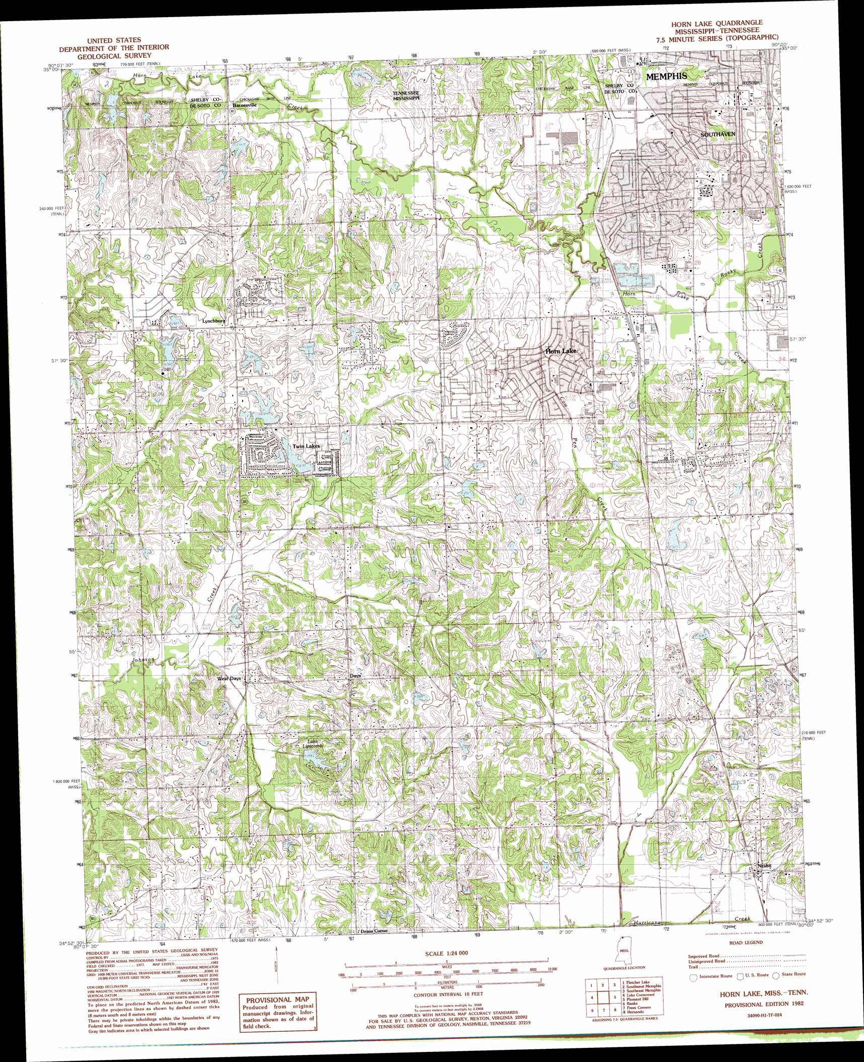
Horn Lake Topo Map Mississippi
To zoom in, hover over the map of Horn Lake
USGS Topo Quad 34090h1 - 1:24,000 scale
| Topo Map Name: | Horn Lake |
| USGS Topo Quad ID: | 34090h1 |
| Print Size: | ca. 21 1/4" wide x 27" high |
| Southeast Coordinates: | 34.875° N latitude / 90° W longitude |
| Map Center Coordinates: | 34.9375° N latitude / 90.0625° W longitude |
| U.S. States: | MS, TN |
| Filename: | o34090h1.jpg |
| Download Map JPG Image: | Horn Lake topo map 1:24,000 scale |
| Map Type: | Topographic |
| Topo Series: | 7.5´ |
| Map Scale: | 1:24,000 |
| Source of Map Images: | United States Geological Survey (USGS) |
| Alternate Map Versions: |
Horn Lake MS 1982, updated 1982 Download PDF Buy paper map Horn Lake MS 2010 Download PDF Buy paper map Horn Lake MS 2012 Download PDF Buy paper map Horn Lake MS 2015 Download PDF Buy paper map |
1:24,000 Topo Quads surrounding Horn Lake
Crawfordsville |
West Memphis |
Northwest Memphis |
Northeast Memphis |
Ellendale |
Edmondson |
Fletcher Lake |
Southwest Memphis |
Southeast Memphis |
Germantown |
Horseshoe Lake |
Lake Cormorant |
Horn Lake |
Pleasant Hill |
Olive Branch |
Robinsonville |
Banks |
Frees Corners |
Hernando |
Lewisburg |
Hollywood |
Arkabutla West |
Arkabutla East |
Coldwater |
Independence |
> Back to 34090e1 at 1:100,000 scale
> Back to 34090a1 at 1:250,000 scale
> Back to U.S. Topo Maps home
Horn Lake topo map: Gazetteer
Horn Lake: Crossings
Interchange 291 elevation 105m 344′Horn Lake: Parks
Boosters Club Park elevation 80m 262′Horn Lake Community Park elevation 83m 272′
Jaycees Park elevation 100m 328′
Horn Lake: Populated Places
Aldens elevation 94m 308′Barnesville elevation 70m 229′
Days elevation 95m 311′
De Soto Village elevation 93m 305′
Deans Corner elevation 99m 324′
Holly Hills elevation 92m 301′
Horn Lake elevation 91m 298′
Lynchburg elevation 92m 301′
Nesbit elevation 85m 278′
Scaife elevation 88m 288′
Southaven elevation 95m 311′
Twin Lakes elevation 89m 291′
West Days elevation 74m 242′
Horn Lake: Post Offices
Horn Lake Post Office elevation 85m 278′Southaven Post Office elevation 92m 301′
Horn Lake: Reservoirs
Lake Lipscomb elevation 82m 269′Horn Lake: Streams
Cow Pen Creek elevation 75m 246′Rocky Creek elevation 79m 259′
Horn Lake digital topo map on disk
Buy this Horn Lake topo map showing relief, roads, GPS coordinates and other geographical features, as a high-resolution digital map file on DVD: