Horseshoe Lake Topo Map Arkansas
To zoom in, hover over the map of Horseshoe Lake
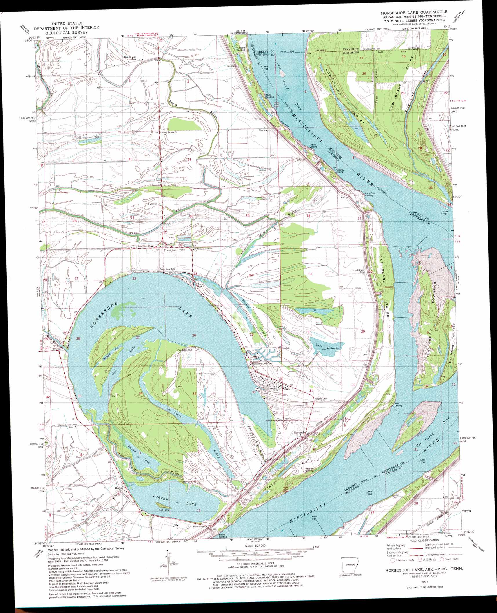
USGS Topo Quad 34090h3 - 1:24,000 scale
| Topo Map Name: | Horseshoe Lake |
| USGS Topo Quad ID: | 34090h3 |
| Print Size: | ca. 21 1/4" wide x 27" high |
| Southeast Coordinates: | 34.875° N latitude / 90.25° W longitude |
| Map Center Coordinates: | 34.9375° N latitude / 90.3125° W longitude |
| U.S. States: | AR, MS, TN |
| Filename: | o34090h3.jpg |
| Download Map JPG Image: | Horseshoe Lake topo map 1:24,000 scale |
| Map Type: | Topographic |
| Topo Series: | 7.5´ |
| Map Scale: | 1:24,000 |
| Source of Map Images: | United States Geological Survey (USGS) |
| Alternate Map Versions: |
Horseshoe Lake NE AR 1975, updated 1976 Download PDF Buy paper map Horseshoe Lake AR 1981, updated 1982 Download PDF Buy paper map Horseshoe Lake AR 1981, updated 1982 Download PDF Buy paper map Horseshoe Lake AR 2011 Download PDF Buy paper map Horseshoe Lake AR 2014 Download PDF Buy paper map |
1:24,000 Topo Quads surrounding Horseshoe Lake
Gieseck |
Jeanette |
Crawfordsville |
West Memphis |
Northwest Memphis |
Round Pond |
Chatfield |
Edmondson |
Fletcher Lake |
Southwest Memphis |
Mud Lake |
Hughes |
Horseshoe Lake |
Lake Cormorant |
Horn Lake |
Brickeys |
Council |
Robinsonville |
Banks |
Frees Corners |
Stubbs Island |
Tunica |
Hollywood |
Arkabutla West |
Arkabutla East |
> Back to 34090e1 at 1:100,000 scale
> Back to 34090a1 at 1:250,000 scale
> Back to U.S. Topo Maps home
Horseshoe Lake topo map: Gazetteer
Horseshoe Lake: Bars
Finley Bar elevation 55m 180′Horseshoe Lake: Bends
Cat Island Bend elevation 53m 173′Cow Island Bend elevation 55m 180′
Cow Island Bend elevation 60m 196′
Horseshoe Lake: Canals
Cat Island Dikes elevation 57m 187′Cow Island Bend Revetment elevation 57m 187′
Rock Chute elevation 62m 203′
Horseshoe Lake: Guts
Boggy Bayou elevation 63m 206′Fish Bayou elevation 61m 200′
Happy Jack elevation 59m 193′
Horseshoe Lake Bayou elevation 62m 203′
Lost River Bayou elevation 62m 203′
Mud Lake elevation 58m 190′
Horseshoe Lake: Islands
Cat Island Number 50 elevation 64m 209′Cat Island Towhead elevation 64m 209′
Cow Island Number Forty-seven elevation 63m 206′
Cow Islands elevation 64m 209′
Goat Island elevation 58m 190′
Harkleroad Towhead elevation 62m 203′
Island Number 47 elevation 63m 206′
Island Number Fortyseven elevation 63m 206′
Horseshoe Lake: Lakes
Bushy Lake elevation 57m 187′Goose Lake elevation 58m 190′
Horseshoe Lake elevation 58m 190′
Lake Deloche elevation 62m 203′
Porter Lake elevation 58m 190′
Horseshoe Lake: Levees
Cat Island Dikes elevation 56m 183′Norfolk Star Revetment elevation 54m 177′
Horseshoe Lake: Populated Places
Bruins elevation 62m 203′Horseshoe Lake elevation 62m 203′
Irby (historical) elevation 63m 206′
Pinckney elevation 64m 209′
Seyppel elevation 65m 213′
Thompson Grove elevation 63m 206′
Horseshoe Lake: Streams
Rock Chute elevation 63m 206′Horseshoe Lake digital topo map on disk
Buy this Horseshoe Lake topo map showing relief, roads, GPS coordinates and other geographical features, as a high-resolution digital map file on DVD: