Weber Topo Map Arkansas
To zoom in, hover over the map of Weber
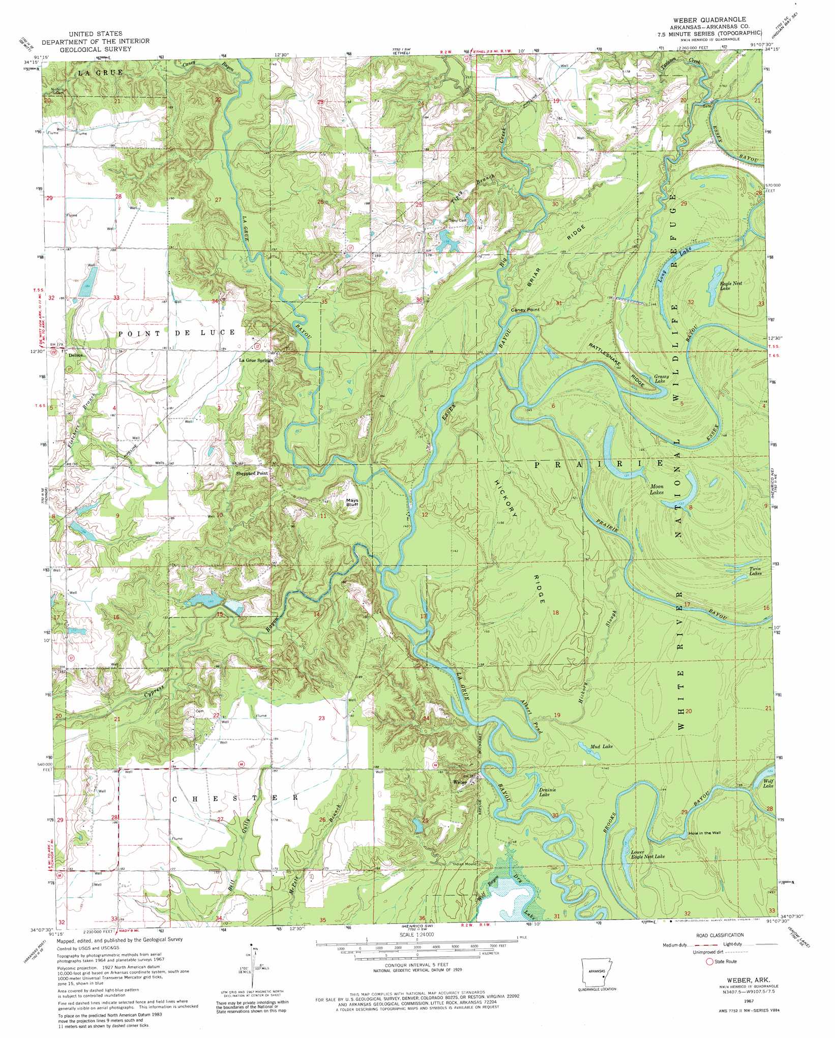
USGS Topo Quad 34091b2 - 1:24,000 scale
| Topo Map Name: | Weber |
| USGS Topo Quad ID: | 34091b2 |
| Print Size: | ca. 21 1/4" wide x 27" high |
| Southeast Coordinates: | 34.125° N latitude / 91.125° W longitude |
| Map Center Coordinates: | 34.1875° N latitude / 91.1875° W longitude |
| U.S. State: | AR |
| Filename: | o34091b2.jpg |
| Download Map JPG Image: | Weber topo map 1:24,000 scale |
| Map Type: | Topographic |
| Topo Series: | 7.5´ |
| Map Scale: | 1:24,000 |
| Source of Map Images: | United States Geological Survey (USGS) |
| Alternate Map Versions: |
Weber AR 1967, updated 1968 Download PDF Buy paper map Weber AR 1967, updated 1981 Download PDF Buy paper map Weber AR 2011 Download PDF Buy paper map Weber AR 2014 Download PDF Buy paper map |
1:24,000 Topo Quads surrounding Weber
Almyra |
De Witt Ne |
Crocketts Bluff |
Turner |
Watkins Corner |
De Witt Sw |
De Witt |
Ethel |
Indian Bay Se |
Lambrook |
One Horse Store |
Tichnor |
Weber |
Henrico Ne |
Mellwood |
Gillett |
Arkansas Post |
Henrico Sw |
Snow Lake |
Laconia |
Dumas |
Watson |
Yancopin |
Montgomery Island |
Gunnison |
> Back to 34091a1 at 1:100,000 scale
> Back to 34090a1 at 1:250,000 scale
> Back to U.S. Topo Maps home
Weber topo map: Gazetteer
Weber: Bays
Albert Pond elevation 44m 144′Weber: Capes
Caney Point elevation 43m 141′Weber: Cliffs
Mays Bluff elevation 47m 154′Weber: Dams
Dudley Lake Dam elevation 54m 177′Potlatch Pond Number One Dam elevation 45m 147′
Potlatch Pond Number Two Dam elevation 46m 150′
Wright Lake Dam elevation 53m 173′
Weber: Guts
Brooks Bayou elevation 44m 144′Hickory Slough elevation 44m 144′
Prairie Bayou elevation 44m 144′
Weber: Lakes
Drainie Lake elevation 41m 134′Eagle Nest Lake elevation 43m 141′
Grassy Lake elevation 41m 134′
Hole in the Wall elevation 46m 150′
Long Lake elevation 44m 144′
Lower Eagle Nest Lake elevation 43m 141′
Moon Lakes elevation 41m 134′
Mud Lake elevation 44m 144′
Twin Lakes elevation 45m 147′
Wolf Lake elevation 44m 144′
Weber: Populated Places
Deluce elevation 55m 180′La Grue Springs elevation 58m 190′
Sheppard Point elevation 59m 193′
Weber elevation 49m 160′
Weber: Reservoirs
Bradberry Pond elevation 45m 147′Dudley Lake elevation 54m 177′
Potlatch Pond Number Two elevation 46m 150′
Wright Lake elevation 53m 173′
Weber: Ridges
Briar Ridge elevation 50m 164′Hickory Ridge elevation 49m 160′
Rattlesnake Ridge elevation 49m 160′
Weber: Streams
Big Creek elevation 43m 141′Caney Bayou elevation 45m 147′
Cypress Bayou elevation 43m 141′
Essex Bayou elevation 43m 141′
Tarleton Creek elevation 48m 157′
Tipsy Branch elevation 44m 144′
Weber digital topo map on disk
Buy this Weber topo map showing relief, roads, GPS coordinates and other geographical features, as a high-resolution digital map file on DVD: