Tichnor Topo Map Arkansas
To zoom in, hover over the map of Tichnor
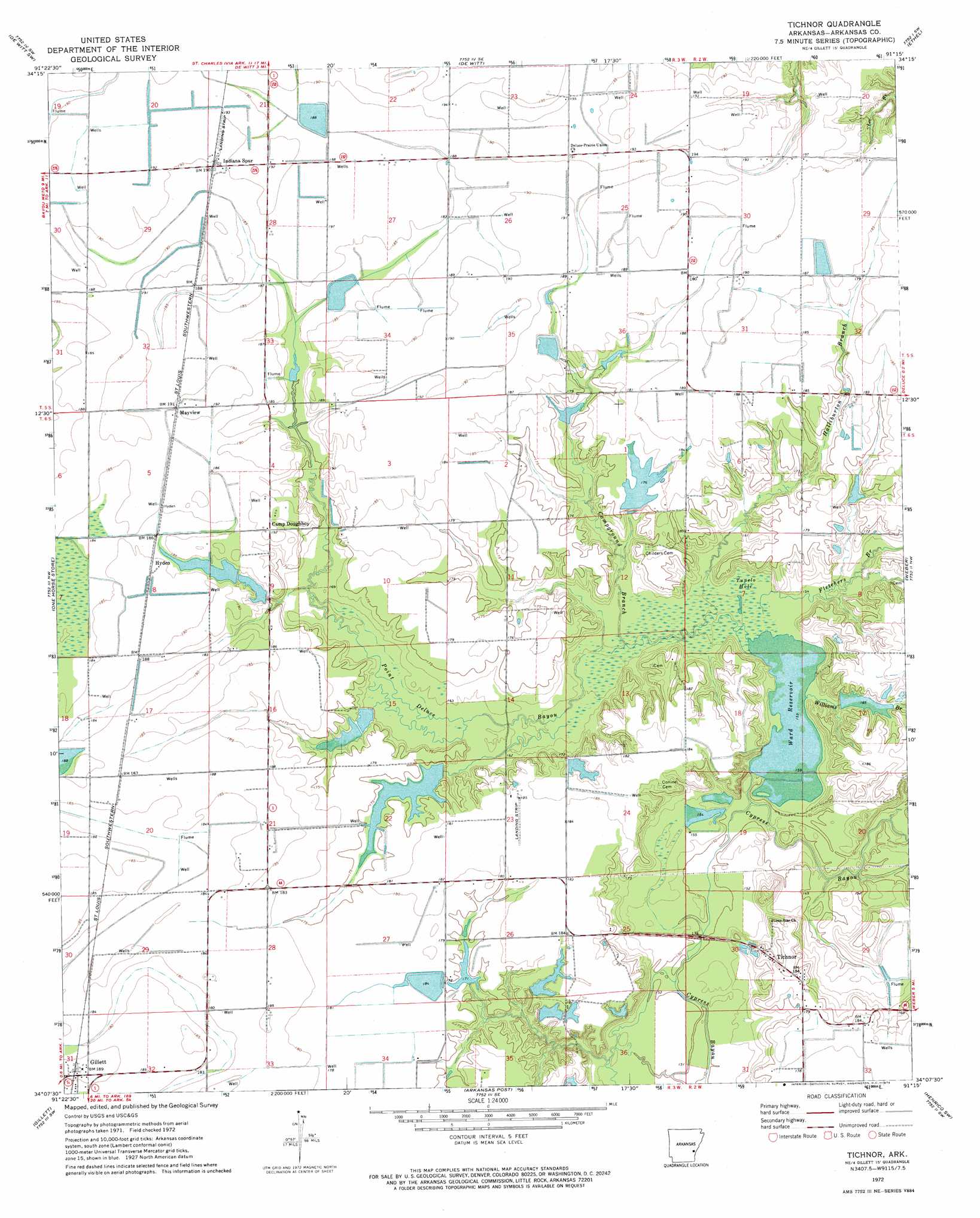
USGS Topo Quad 34091b3 - 1:24,000 scale
| Topo Map Name: | Tichnor |
| USGS Topo Quad ID: | 34091b3 |
| Print Size: | ca. 21 1/4" wide x 27" high |
| Southeast Coordinates: | 34.125° N latitude / 91.25° W longitude |
| Map Center Coordinates: | 34.1875° N latitude / 91.3125° W longitude |
| U.S. State: | AR |
| Filename: | o34091b3.jpg |
| Download Map JPG Image: | Tichnor topo map 1:24,000 scale |
| Map Type: | Topographic |
| Topo Series: | 7.5´ |
| Map Scale: | 1:24,000 |
| Source of Map Images: | United States Geological Survey (USGS) |
| Alternate Map Versions: |
Tichnor AR 1972, updated 1974 Download PDF Buy paper map Tichnor AR 2011 Download PDF Buy paper map Tichnor AR 2014 Download PDF Buy paper map |
1:24,000 Topo Quads surrounding Tichnor
Stuttgart South |
Almyra |
De Witt Ne |
Crocketts Bluff |
Turner |
Lodge Corner |
De Witt Sw |
De Witt |
Ethel |
Indian Bay Se |
Reydell |
One Horse Store |
Tichnor |
Weber |
Henrico Ne |
Cades |
Gillett |
Arkansas Post |
Henrico Sw |
Snow Lake |
Gould |
Dumas |
Watson |
Yancopin |
Montgomery Island |
> Back to 34091a1 at 1:100,000 scale
> Back to 34090a1 at 1:250,000 scale
> Back to U.S. Topo Maps home
Tichnor topo map: Gazetteer
Tichnor: Dams
Botts Lake Dam elevation 57m 187′Childers Lake Dam elevation 48m 157′
Gregory Lake Dam elevation 54m 177′
Jenkins Lake Dam elevation 53m 173′
La Fargue Lake Dam elevation 56m 183′
Lake Wisdom Dam elevation 53m 173′
Lowe Lake Dam elevation 53m 173′
McCracken Lake Dam elevation 51m 167′
Tichnor: Populated Places
Buffo (historical) elevation 58m 190′Hyden elevation 58m 190′
Mayview elevation 59m 193′
Prairie Union elevation 61m 200′
Tichnor elevation 55m 180′
Tichnor: Post Offices
Tichnor Post Office elevation 57m 187′Tichnor: Reservoirs
Botts Lake elevation 57m 187′Childers Lake Dam elevation 48m 157′
Gregory Lake elevation 54m 177′
Jenkins Lake elevation 53m 173′
La Fargue Lake elevation 56m 183′
Lake Wisdom elevation 53m 173′
Lowe Lake elevation 53m 173′
McCracken Lake elevation 51m 167′
Ward Reservoir elevation 48m 157′
Tichnor: Streams
Campground Branch elevation 49m 160′Fletchers Branch elevation 53m 173′
Halliburton Branch elevation 49m 160′
Point Deluce Bayou elevation 52m 170′
Williams Branch elevation 50m 164′
Tichnor: Swamps
Tupelo Hole elevation 48m 157′Tichnor digital topo map on disk
Buy this Tichnor topo map showing relief, roads, GPS coordinates and other geographical features, as a high-resolution digital map file on DVD: