Crocketts Bluff Topo Map Arkansas
To zoom in, hover over the map of Crocketts Bluff
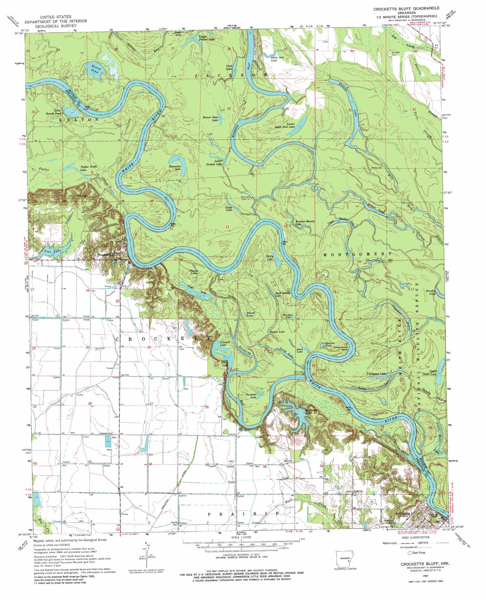
USGS Topo Quad 34091d2 - 1:24,000 scale
| Topo Map Name: | Crocketts Bluff |
| USGS Topo Quad ID: | 34091d2 |
| Print Size: | ca. 21 1/4" wide x 27" high |
| Southeast Coordinates: | 34.375° N latitude / 91.125° W longitude |
| Map Center Coordinates: | 34.4375° N latitude / 91.1875° W longitude |
| U.S. State: | AR |
| Filename: | o34091d2.jpg |
| Download Map JPG Image: | Crocketts Bluff topo map 1:24,000 scale |
| Map Type: | Topographic |
| Topo Series: | 7.5´ |
| Map Scale: | 1:24,000 |
| Source of Map Images: | United States Geological Survey (USGS) |
| Alternate Map Versions: |
Crocketts Bluff AR 1967, updated 1968 Download PDF Buy paper map Crocketts Bluff AR 1967, updated 1984 Download PDF Buy paper map Crocketts Bluff AR 1967, updated 1984 Download PDF Buy paper map Crocketts Bluff AR 2011 Download PDF Buy paper map Crocketts Bluff AR 2014 Download PDF Buy paper map |
1:24,000 Topo Quads surrounding Crocketts Bluff
Roe |
Clarendon |
Park Grove |
Monroe |
Aubrey |
Ulm |
Aberdeen |
Holly Grove |
Pine City |
Marvell |
Almyra |
De Witt Ne |
Crocketts Bluff |
Turner |
Watkins Corner |
De Witt Sw |
De Witt |
Ethel |
Indian Bay Se |
Lambrook |
One Horse Store |
Tichnor |
Weber |
Henrico Ne |
Mellwood |
> Back to 34091a1 at 1:100,000 scale
> Back to 34090a1 at 1:250,000 scale
> Back to U.S. Topo Maps home
Crocketts Bluff topo map: Gazetteer
Crocketts Bluff: Bays
Anderson Bay elevation 44m 144′Crocketts Bluff: Canals
Tarleton Ditch elevation 59m 193′Crocketts Bluff: Capes
Cottonwood Point elevation 47m 154′Crocketts Bluff: Dams
Eason Lake Dam elevation 57m 187′Southern Lake Dam elevation 52m 170′
Stinking Bay Dam elevation 46m 150′
Voss Lake Dam elevation 62m 203′
Crocketts Bluff: Guts
Anderson Chute elevation 43m 141′Lambert Bayou elevation 43m 141′
Lower Eagle Nest Lake elevation 47m 154′
Sandy Bayou elevation 46m 150′
Stinking Bay elevation 47m 154′
Crocketts Bluff: Lakes
Bark Shanty Lake elevation 49m 160′Beaver Dam Lake elevation 48m 157′
Browns Shanty Lake elevation 44m 144′
Brushy Lake elevation 47m 154′
Brushy Lake elevation 45m 147′
Crab Lake elevation 45m 147′
Crockett Lake elevation 46m 150′
Ditch Lake elevation 46m 150′
Goose Lake elevation 48m 157′
Goosefoot Lake elevation 47m 154′
Gordon Lake elevation 47m 154′
Holly Lake elevation 46m 150′
Horseshoe Lake elevation 47m 154′
Kansas Lake elevation 47m 154′
Leak Lake elevation 47m 154′
Little Lake elevation 45m 147′
Little Moon Lake elevation 45m 147′
Little Round Pond elevation 48m 157′
Long Lake elevation 48m 157′
Long Lake elevation 45m 147′
Lower Forked Lake elevation 49m 160′
Polecat Lakes elevation 49m 160′
Poplar Creek Lake elevation 49m 160′
Round Lake elevation 46m 150′
Round Pond elevation 44m 144′
Simpson Lake elevation 48m 157′
Tupelo Lake elevation 49m 160′
Upper Forked Lake elevation 47m 154′
Upper Hooked Lake elevation 46m 150′
Upper Swan Lake elevation 44m 144′
White Oak Lake elevation 47m 154′
Willow Lake elevation 46m 150′
Crocketts Bluff: Populated Places
Crocketts Bluff elevation 49m 160′Stinking Bay elevation 62m 203′
Crocketts Bluff: Post Offices
Crocketts Bluff Post Office elevation 63m 206′Crocketts Bluff: Reservoirs
Eason Lake elevation 57m 187′Southern Lake elevation 52m 170′
Stinking Bay Reservoir elevation 46m 150′
Voss Lake elevation 62m 203′
Crocketts Bluff: Streams
Maddox Bay elevation 48m 157′Poplar Creek elevation 48m 157′
Crocketts Bluff digital topo map on disk
Buy this Crocketts Bluff topo map showing relief, roads, GPS coordinates and other geographical features, as a high-resolution digital map file on DVD: