De Witt Ne Topo Map Arkansas
To zoom in, hover over the map of De Witt Ne
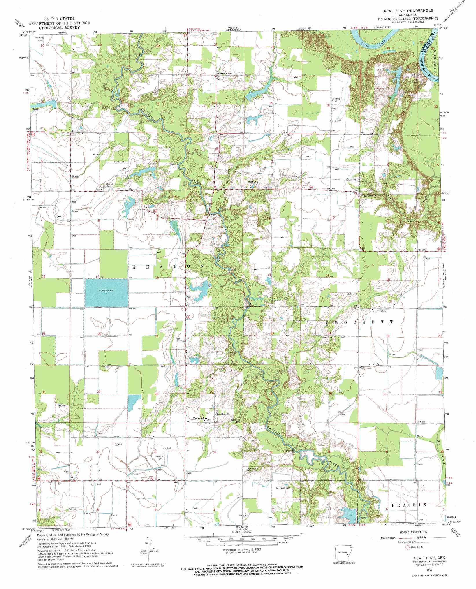
USGS Topo Quad 34091d3 - 1:24,000 scale
| Topo Map Name: | De Witt Ne |
| USGS Topo Quad ID: | 34091d3 |
| Print Size: | ca. 21 1/4" wide x 27" high |
| Southeast Coordinates: | 34.375° N latitude / 91.25° W longitude |
| Map Center Coordinates: | 34.4375° N latitude / 91.3125° W longitude |
| U.S. State: | AR |
| Filename: | o34091d3.jpg |
| Download Map JPG Image: | De Witt Ne topo map 1:24,000 scale |
| Map Type: | Topographic |
| Topo Series: | 7.5´ |
| Map Scale: | 1:24,000 |
| Source of Map Images: | United States Geological Survey (USGS) |
| Alternate Map Versions: |
De Witt NE AR 1968, updated 1969 Download PDF Buy paper map De Witt NE AR 2011 Download PDF Buy paper map De Witt NE AR 2014 Download PDF Buy paper map |
1:24,000 Topo Quads surrounding De Witt Ne
Slovak |
Roe |
Clarendon |
Park Grove |
Monroe |
Stuttgart North |
Ulm |
Aberdeen |
Holly Grove |
Pine City |
Stuttgart South |
Almyra |
De Witt Ne |
Crocketts Bluff |
Turner |
Lodge Corner |
De Witt Sw |
De Witt |
Ethel |
Indian Bay Se |
Reydell |
One Horse Store |
Tichnor |
Weber |
Henrico Ne |
> Back to 34091a1 at 1:100,000 scale
> Back to 34090a1 at 1:250,000 scale
> Back to U.S. Topo Maps home
De Witt Ne topo map: Gazetteer
De Witt Ne: Dams
Abernathy Reservoir Dam elevation 62m 203′Gunnell Pond Dam elevation 61m 200′
J Gunnell Lake Dam elevation 60m 196′
Lake Lane Dam elevation 56m 183′
Leibrock Lake Dam elevation 63m 206′
McGraw Lake Dam elevation 60m 196′
Shook Reservoir Dam elevation 58m 190′
Wofford Lake Dam elevation 51m 167′
De Witt Ne: Populated Places
Immanuel elevation 63m 206′LaGrue elevation 59m 193′
Mount Adams elevation 56m 183′
Plainview elevation 62m 203′
Sassafras (historical) elevation 62m 203′
De Witt Ne: Reservoirs
Abernathy Reservoir elevation 62m 203′Gunnell Pond elevation 61m 200′
J Gunnell Lake elevation 60m 196′
Lake Lane elevation 56m 183′
Leibrock Lake elevation 63m 206′
McGraw Lake elevation 60m 196′
Shook Reservoir elevation 58m 190′
Wofford Lake elevation 51m 167′
De Witt Ne digital topo map on disk
Buy this De Witt Ne topo map showing relief, roads, GPS coordinates and other geographical features, as a high-resolution digital map file on DVD: