De Valls Bluff Se Topo Map Arkansas
To zoom in, hover over the map of De Valls Bluff Se
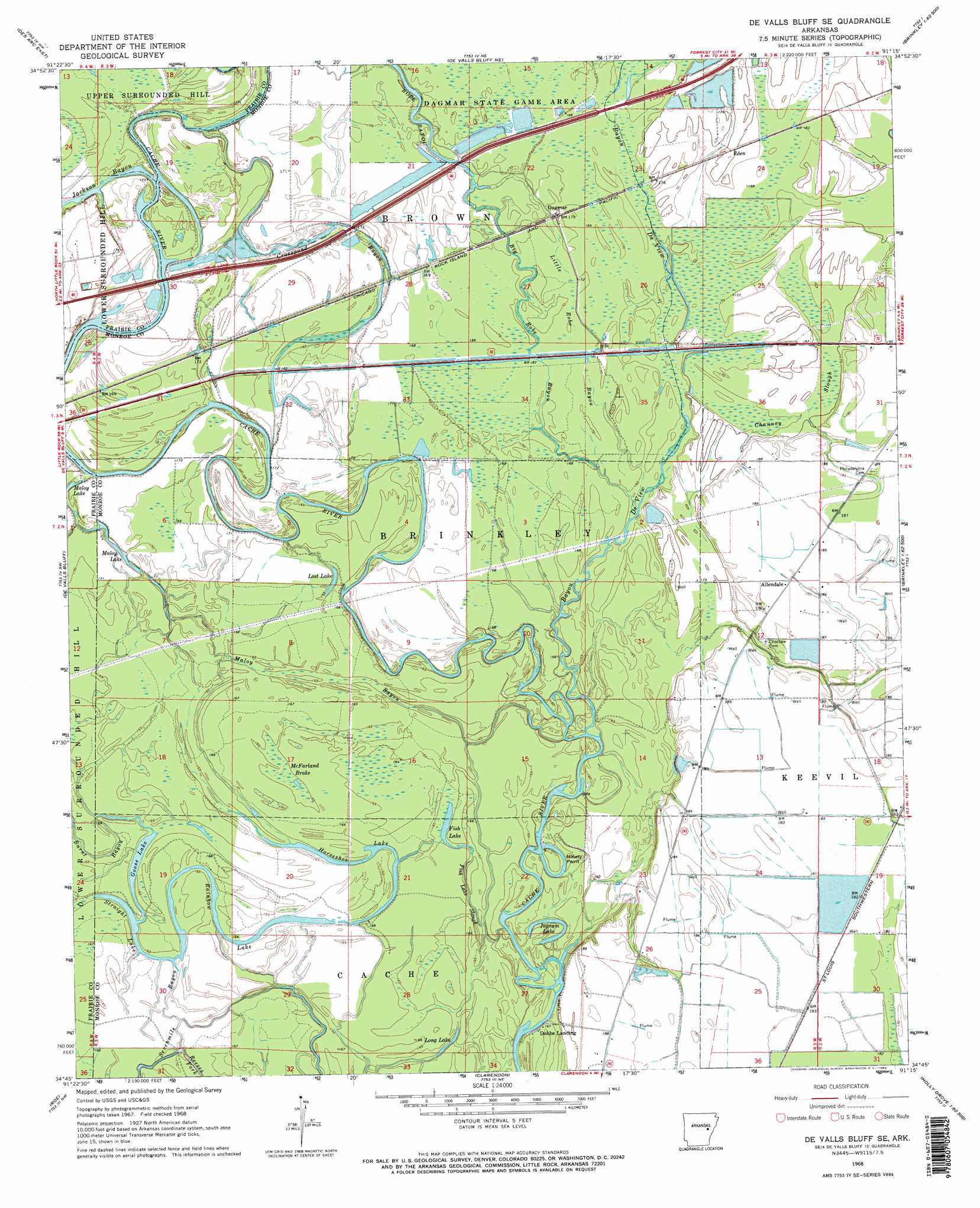
USGS Topo Quad 34091g3 - 1:24,000 scale
| Topo Map Name: | De Valls Bluff Se |
| USGS Topo Quad ID: | 34091g3 |
| Print Size: | ca. 21 1/4" wide x 27" high |
| Southeast Coordinates: | 34.75° N latitude / 91.25° W longitude |
| Map Center Coordinates: | 34.8125° N latitude / 91.3125° W longitude |
| U.S. State: | AR |
| Filename: | o34091g3.jpg |
| Download Map JPG Image: | De Valls Bluff Se topo map 1:24,000 scale |
| Map Type: | Topographic |
| Topo Series: | 7.5´ |
| Map Scale: | 1:24,000 |
| Source of Map Images: | United States Geological Survey (USGS) |
| Alternate Map Versions: |
De Valls Bluff SE AR 1968, updated 1969 Download PDF Buy paper map De Valls Bluff SE AR 1968, updated 1970 Download PDF Buy paper map De Valls Bluff SE AR 2011 Download PDF Buy paper map De Valls Bluff SE AR 2014 Download PDF Buy paper map |
1:24,000 Topo Quads surrounding De Valls Bluff Se
Jasmine |
Gregory Sw |
Cotton Plant |
Hunter West |
Hunter East |
Des Arc West |
Des Arc East |
De Valls Bluff Ne |
Brinkley |
Wheatley |
Hazen |
De Valls Bluff |
De Valls Bluff Se |
Keevil |
Garrett Grove |
Slovak |
Roe |
Clarendon |
Park Grove |
Monroe |
Stuttgart North |
Ulm |
Aberdeen |
Holly Grove |
Pine City |
> Back to 34091e1 at 1:100,000 scale
> Back to 34090a1 at 1:250,000 scale
> Back to U.S. Topo Maps home
De Valls Bluff Se topo map: Gazetteer
De Valls Bluff Se: Areas
Jones Island elevation 54m 177′De Valls Bluff Se: Bends
Ninety Point elevation 51m 167′De Valls Bluff Se: Guts
Big Robe Bayou elevation 52m 170′Channey Slough elevation 52m 170′
Crosspond Bayou elevation 52m 170′
Fish Lake Slough elevation 50m 164′
Maloy Bayou elevation 48m 157′
Reeses Fork elevation 48m 157′
De Valls Bluff Se: Lakes
Fish Lake elevation 47m 154′Goose Lake elevation 50m 164′
Horseshoe Lake elevation 48m 157′
Ingram Lake elevation 49m 160′
Long Lake elevation 50m 164′
Lost Lake elevation 49m 160′
Maloy Lake elevation 49m 160′
Rainbow Lake elevation 48m 157′
Straight Lake elevation 49m 160′
De Valls Bluff Se: Populated Places
Allendale elevation 56m 183′Dagmar elevation 54m 177′
Dobbs Landing elevation 49m 160′
Eden elevation 55m 180′
De Valls Bluff Se: Streams
Bayou De View elevation 48m 157′Jackson Bayou elevation 50m 164′
Little Robe Bayou elevation 49m 160′
Sevenmile Bayou elevation 49m 160′
De Valls Bluff Se: Swamps
McFarland Brake elevation 50m 164′De Valls Bluff Se digital topo map on disk
Buy this De Valls Bluff Se topo map showing relief, roads, GPS coordinates and other geographical features, as a high-resolution digital map file on DVD: