Pine Bluff Topo Map Arkansas
To zoom in, hover over the map of Pine Bluff
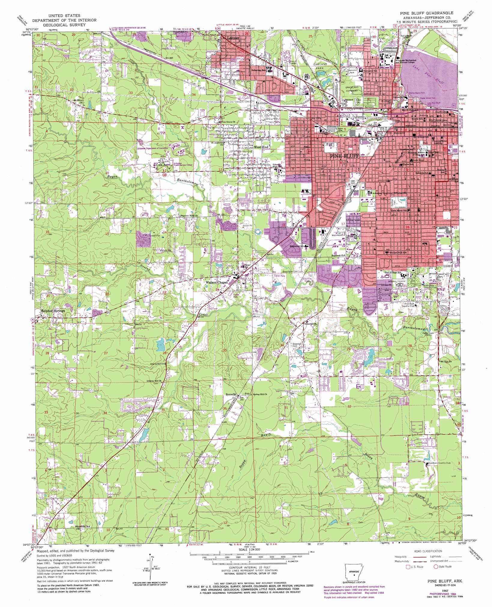
USGS Topo Quad 34092b1 - 1:24,000 scale
| Topo Map Name: | Pine Bluff |
| USGS Topo Quad ID: | 34092b1 |
| Print Size: | ca. 21 1/4" wide x 27" high |
| Southeast Coordinates: | 34.125° N latitude / 92° W longitude |
| Map Center Coordinates: | 34.1875° N latitude / 92.0625° W longitude |
| U.S. State: | AR |
| Filename: | o34092b1.jpg |
| Download Map JPG Image: | Pine Bluff topo map 1:24,000 scale |
| Map Type: | Topographic |
| Topo Series: | 7.5´ |
| Map Scale: | 1:24,000 |
| Source of Map Images: | United States Geological Survey (USGS) |
| Alternate Map Versions: |
Pine Bluff AR 1962, updated 1963 Download PDF Buy paper map Pine Bluff AR 1962, updated 1973 Download PDF Buy paper map Pine Bluff AR 1962, updated 1978 Download PDF Buy paper map Pine Bluff AR 1962, updated 1984 Download PDF Buy paper map Pine Bluff AR 2011 Download PDF Buy paper map Pine Bluff AR 2014 Download PDF Buy paper map |
1:24,000 Topo Quads surrounding Pine Bluff
Cane Creek |
Redfield |
Wright |
Sherrill |
Gethsemane |
Prague |
Hardin |
White Hall |
Rob Roy |
Altheimer |
Grapevine |
Pine Bluff Nw |
Pine Bluff |
Ladd |
Moscow |
Staves |
Kedron |
Faith |
Pinebergen |
Tarry |
Fordyce Ne |
Rison |
Calmer |
Glendale |
Star City |
> Back to 34092a1 at 1:100,000 scale
> Back to 34092a1 at 1:250,000 scale
> Back to U.S. Topo Maps home
Pine Bluff topo map: Gazetteer
Pine Bluff: Airports
Jrmc Heliport elevation 71m 232′Pine Bluff: Dams
Lake Pine Bluff Dam elevation 63m 206′Midland Lake Dam elevation 69m 226′
Neely Lake Dam elevation 77m 252′
Oakley Lake Dam elevation 77m 252′
Oakley Lake Number Two Dam elevation 78m 255′
Suburbia Lake Dam elevation 81m 265′
Pine Bluff: Parks
Brump Bayou Park elevation 69m 226′Central Park elevation 70m 229′
Lake Pine Bluff Park elevation 69m 226′
Oakland Park elevation 70m 229′
Poplar Street Park elevation 68m 223′
Townsend Park elevation 72m 236′
Pine Bluff: Populated Places
Pine Bluff elevation 69m 226′Sorrells elevation 87m 285′
Sulphur Springs elevation 91m 298′
Watson Chapel elevation 73m 239′
West End elevation 72m 236′
Pine Bluff: Post Offices
Pine Bluff Post Office elevation 67m 219′Pine Bluff: Reservoirs
Lake Pine Bluff elevation 63m 206′Midland Lake elevation 69m 226′
Neely Lake elevation 77m 252′
Oakley Lake elevation 77m 252′
Oakley Lake Number Two elevation 78m 255′
Suburbia Lake elevation 81m 265′
Pine Bluff: Streams
Nevins Creek elevation 65m 213′Pine Bluff digital topo map on disk
Buy this Pine Bluff topo map showing relief, roads, GPS coordinates and other geographical features, as a high-resolution digital map file on DVD: