Traskwood Topo Map Arkansas
To zoom in, hover over the map of Traskwood
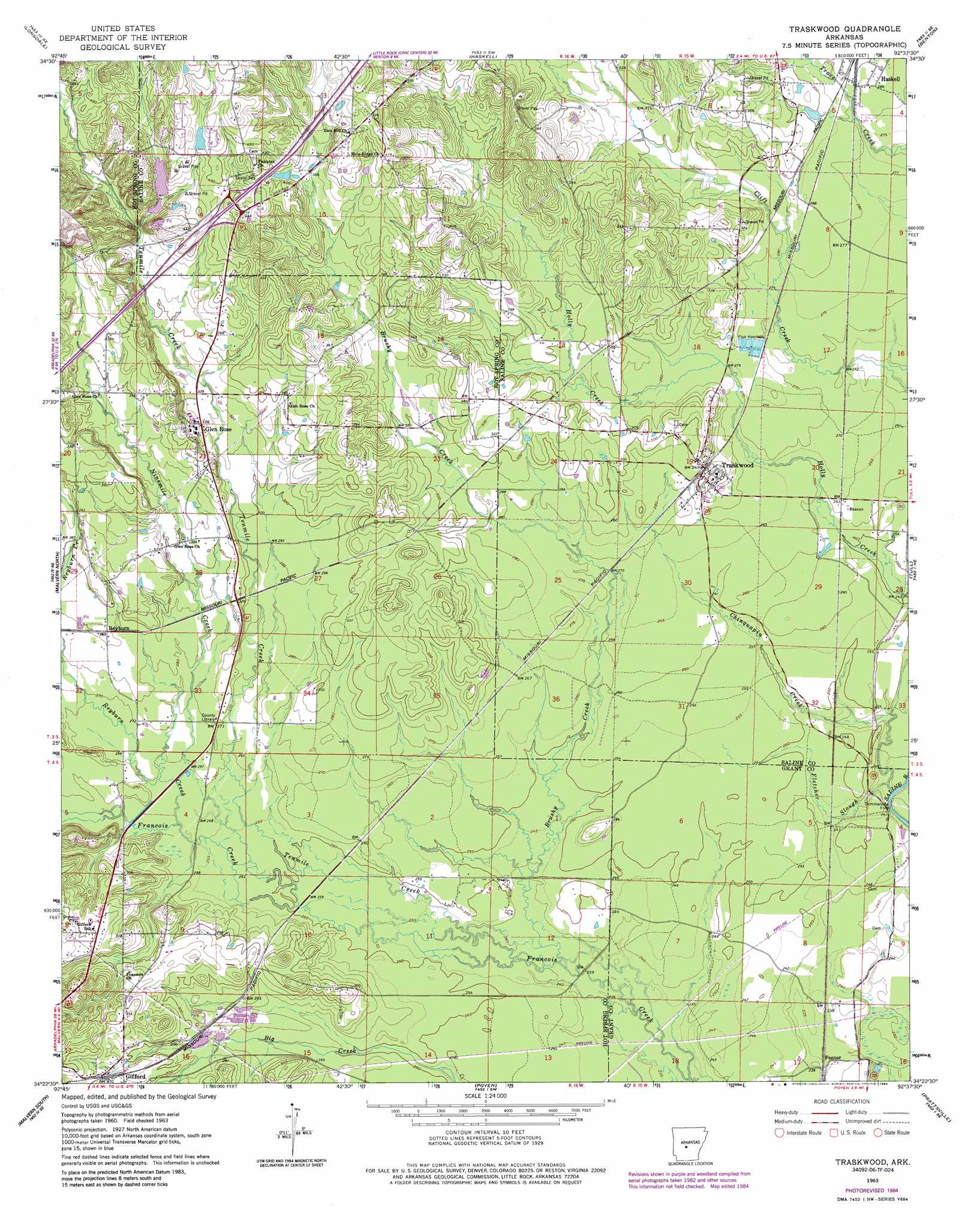
USGS Topo Quad 34092d6 - 1:24,000 scale
| Topo Map Name: | Traskwood |
| USGS Topo Quad ID: | 34092d6 |
| Print Size: | ca. 21 1/4" wide x 27" high |
| Southeast Coordinates: | 34.375° N latitude / 92.625° W longitude |
| Map Center Coordinates: | 34.4375° N latitude / 92.6875° W longitude |
| U.S. State: | AR |
| Filename: | o34092d6.jpg |
| Download Map JPG Image: | Traskwood topo map 1:24,000 scale |
| Map Type: | Topographic |
| Topo Series: | 7.5´ |
| Map Scale: | 1:24,000 |
| Source of Map Images: | United States Geological Survey (USGS) |
| Alternate Map Versions: |
Traskwood AR 1963, updated 1964 Download PDF Buy paper map Traskwood AR 1963, updated 1975 Download PDF Buy paper map Traskwood AR 1963, updated 1976 Download PDF Buy paper map Traskwood AR 1963, updated 1984 Download PDF Buy paper map Traskwood AR 2011 Download PDF Buy paper map Traskwood AR 2014 Download PDF Buy paper map |
1:24,000 Topo Quads surrounding Traskwood
Goosepond Moutain |
Lonsdale Ne |
Lake Norrell |
Congo |
Alexander |
Fountain Lake |
Lonsdale |
Haskell |
Benton |
Bryant |
Lake Catherine |
Malvern North |
Traskwood |
Tull |
Belfast |
Social Hill |
Malvern South |
Poyen |
Prattsville |
Sheridan |
Donaldson |
Round Hill |
Willow |
Leola |
Millerville |
> Back to 34092a1 at 1:100,000 scale
> Back to 34092a1 at 1:250,000 scale
> Back to U.S. Topo Maps home
Traskwood topo map: Gazetteer
Traskwood: Crossings
Interchange 106 elevation 133m 436′Summerville Ford elevation 70m 229′
Traskwood: Dams
Barr Lake Dam elevation 132m 433′Dawson Lake Dam elevation 127m 416′
Lake Krislor Dam elevation 143m 469′
Pathway Youth Camp Lake Dam elevation 139m 456′
Traskwood: Populated Places
Cunningham (historical) elevation 80m 262′Fenter elevation 73m 239′
Gifford elevation 97m 318′
Glen Rose elevation 102m 334′
Opitz (historical) elevation 92m 301′
Traskwood elevation 95m 311′
Wyandotte (historical) elevation 89m 291′
Traskwood: Reservoirs
Barr Lake elevation 132m 433′Dawson Lake elevation 127m 416′
Lake Krislor elevation 143m 469′
Pathway Youth Camp Lake elevation 139m 456′
Traskwood: Streams
Brushy Creek elevation 73m 239′Chinquapin Creek elevation 67m 219′
Fletcher Slough elevation 69m 226′
Ninemile Creek elevation 78m 255′
Reyburn Creek elevation 77m 252′
Tenmile Creek elevation 76m 249′
Traskwood digital topo map on disk
Buy this Traskwood topo map showing relief, roads, GPS coordinates and other geographical features, as a high-resolution digital map file on DVD: