Bryant Topo Map Arkansas
To zoom in, hover over the map of Bryant
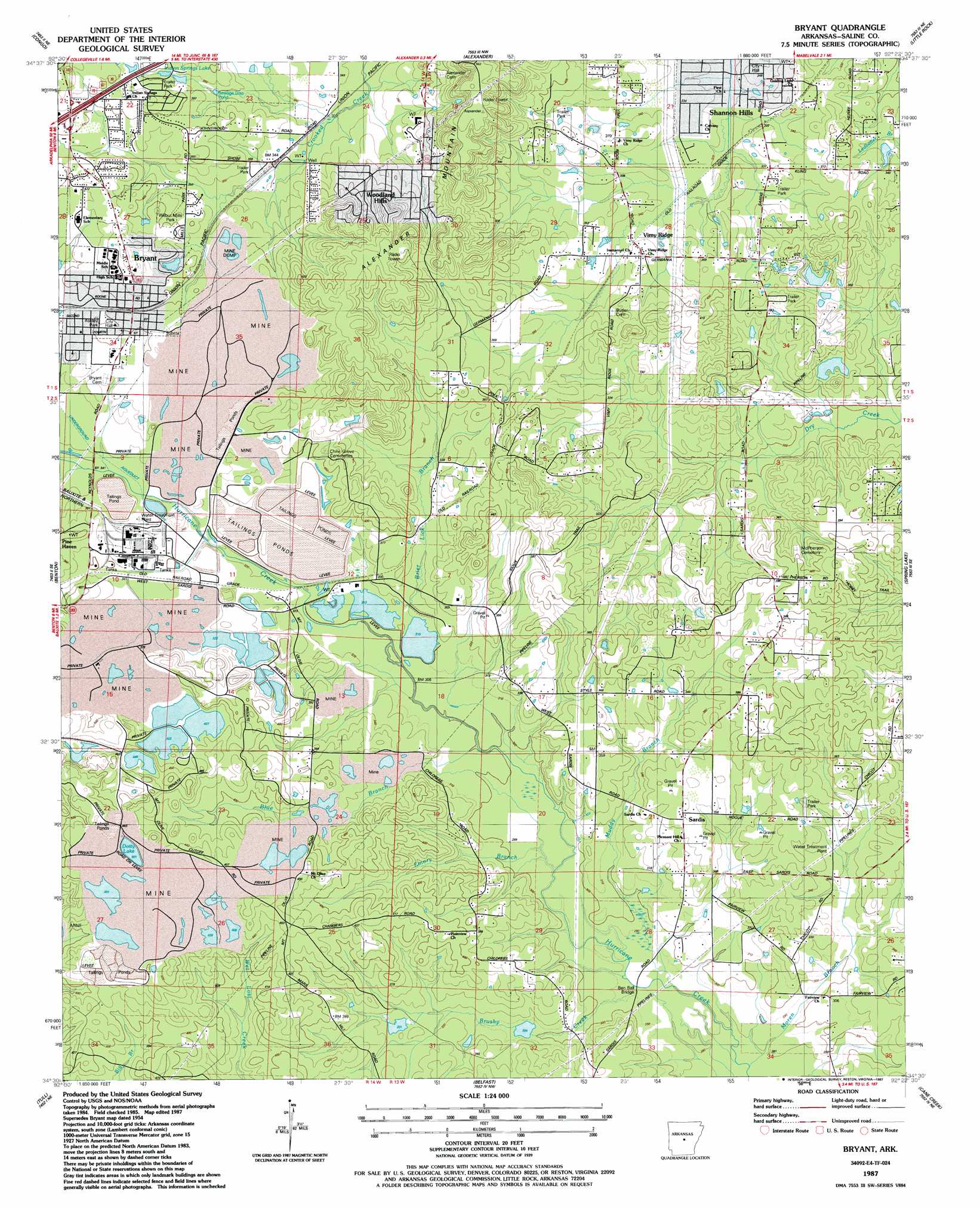
USGS Topo Quad 34092e4 - 1:24,000 scale
| Topo Map Name: | Bryant |
| USGS Topo Quad ID: | 34092e4 |
| Print Size: | ca. 21 1/4" wide x 27" high |
| Southeast Coordinates: | 34.5° N latitude / 92.375° W longitude |
| Map Center Coordinates: | 34.5625° N latitude / 92.4375° W longitude |
| U.S. State: | AR |
| Filename: | o34092e4.jpg |
| Download Map JPG Image: | Bryant topo map 1:24,000 scale |
| Map Type: | Topographic |
| Topo Series: | 7.5´ |
| Map Scale: | 1:24,000 |
| Source of Map Images: | United States Geological Survey (USGS) |
| Alternate Map Versions: |
Bryant AR 1954, updated 1957 Download PDF Buy paper map Bryant AR 1954, updated 1971 Download PDF Buy paper map Bryant AR 1954, updated 1976 Download PDF Buy paper map Bryant AR 1987, updated 1987 Download PDF Buy paper map Bryant AR 1994, updated 2000 Download PDF Buy paper map Bryant AR 2011 Download PDF Buy paper map Bryant AR 2014 Download PDF Buy paper map |
1:24,000 Topo Quads surrounding Bryant
Fourche Sw |
Ferndale |
Pinnacle Mountain |
North Little Rock |
Mcalmont |
Lake Norrell |
Congo |
Alexander |
Little Rock |
Sweet Home |
Haskell |
Benton |
Bryant |
Spring Lake |
Woodson |
Traskwood |
Tull |
Belfast |
Cane Creek |
Redfield |
Poyen |
Prattsville |
Sheridan |
Prague |
Hardin |
> Back to 34092e1 at 1:100,000 scale
> Back to 34092a1 at 1:250,000 scale
> Back to U.S. Topo Maps home
Bryant topo map: Gazetteer
Bryant: Bridges
Ben Ball Bridge elevation 87m 285′Bryant: Crossings
Interchange 123 elevation 130m 426′Bryant: Dams
King Lake Dam elevation 102m 334′Old Brown Mud Lake Dam elevation 126m 413′
Styres Lake Dam elevation 105m 344′
Surge Pond Dam elevation 113m 370′
Surge Pond Dam elevation 112m 367′
Bryant: Lakes
Dotty Lake elevation 149m 488′Bryant: Mines
African Camp Mine elevation 117m 383′Alexander Hill Mine elevation 129m 423′
Bertha Extension Mine elevation 113m 370′
Bertha Mine elevation 146m 479′
Bertha Underground Mine elevation 136m 446′
Bizzell Mine elevation 97m 318′
Bryant Mine elevation 117m 383′
Canal Number 1 Mine elevation 108m 354′
Canal Number 2 Mine elevation 111m 364′
Cargill Mine elevation 121m 396′
Cargill Mine elevation 129m 423′
Cargill North Shaft Mine elevation 113m 370′
Cargill South Shaft Mine elevation 131m 429′
Childress Mine elevation 108m 354′
Cleveland Mine elevation 114m 374′
Cleveland Mine elevation 106m 347′
Cleveland-Evans Mine elevation 110m 360′
Covington Number 4 Mine elevation 96m 314′
Covington Number 5 Mine elevation 95m 311′
Davis Main Portal Mine elevation 138m 452′
East Maud Mine elevation 127m 416′
East Neilson Mine elevation 146m 479′
East Ozark Mine elevation 100m 328′
Ella Mine elevation 144m 472′
Elrod Mine elevation 104m 341′
Fletcher Mine elevation 106m 347′
Gates Mine elevation 102m 334′
Globe Mine elevation 141m 462′
Granite Branch Mine elevation 143m 469′
Gray East Pit Mine elevation 99m 324′
Gray West Pit Mine elevation 109m 357′
Hogue-Fletcher Mine elevation 98m 321′
Hurricane Mine elevation 95m 311′
Johnson New Pit Mine elevation 143m 469′
Johnson Old Pit Mine elevation 149m 488′
Julia Mine elevation 161m 528′
Lantz Mine elevation 123m 403′
Martin Mine elevation 116m 380′
Mary Mine elevation 145m 475′
McDonald Mine elevation 102m 334′
Middle Maud Mine elevation 145m 475′
Midwest Mine elevation 99m 324′
Mine 14 elevation 106m 347′
Neilson Mine elevation 144m 472′
Norton Mine elevation 120m 393′
Ozark 24 Mine elevation 104m 341′
Quapaw North Pit Mine elevation 101m 331′
Quapaw South Pit Mine elevation 99m 324′
Rowland Mine elevation 117m 383′
Section 10 Mine elevation 123m 403′
Section 14 East Pit Mine elevation 98m 321′
Section 14 West Pit Mine elevation 107m 351′
Section 15 Mine elevation 127m 416′
Section 26 Mine elevation 149m 488′
Stringtown Mine elevation 133m 436′
Townsend Mine elevation 97m 318′
Ulmer Mine elevation 93m 305′
West Elrod Mine elevation 108m 354′
West Maud Extension Mine elevation 122m 400′
West Maud Mine elevation 122m 400′
West Ozark Mine elevation 106m 347′
Bryant: Parks
Ashley Park elevation 120m 393′Bryant Stadium elevation 122m 400′
Wilbur Mills Park elevation 117m 383′
Bryant: Populated Places
Brooks elevation 104m 341′Brooks (historical) elevation 105m 344′
Bryant elevation 125m 410′
Bryant Oaks elevation 109m 357′
Careywood elevation 121m 396′
Dirtdauber (historical) elevation 119m 390′
Evergreen elevation 110m 360′
Goodman elevation 99m 324′
Hurricane (historical) elevation 110m 360′
Lignite elevation 105m 344′
Pine Haven elevation 103m 337′
Raintree Acres elevation 117m 383′
Sardis elevation 112m 367′
Shannon Hills elevation 103m 337′
Twin Oaks elevation 129m 423′
Vimy Ridge elevation 108m 354′
Woodland Hills elevation 141m 462′
Bryant: Reservoirs
Indian Springs Lake elevation 113m 370′King Lake elevation 102m 334′
Old Brown Mud Lakes elevation 126m 413′
Styres Lake elevation 105m 344′
Surge Pond elevation 112m 367′
Surge Pond elevation 113m 370′
Bryant: Streams
Blue Branch elevation 97m 318′Brier Lick Branch elevation 96m 314′
Brushy Creek elevation 87m 285′
Cold Spring Branch elevation 98m 321′
Dry Creek elevation 86m 282′
Emory Branch elevation 88m 288′
Moren Branch elevation 83m 272′
Muddy Branch elevation 87m 285′
Bryant: Summits
Alexander Mountain elevation 174m 570′Bryant digital topo map on disk
Buy this Bryant topo map showing relief, roads, GPS coordinates and other geographical features, as a high-resolution digital map file on DVD: