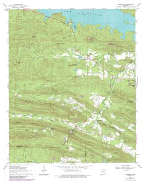
Ferndale Topo Map Arkansas
To zoom in, hover over the map of Ferndale
USGS Topo Quad 34092g5 - 1:24,000 scale
| Topo Map Name: | Ferndale |
| USGS Topo Quad ID: | 34092g5 |
| Print Size: | ca. 21 1/4" wide x 27" high |
| Southeast Coordinates: | 34.75° N latitude / 92.5° W longitude |
| Map Center Coordinates: | 34.8125° N latitude / 92.5625° W longitude |
| U.S. State: | AR |
| Filename: | o34092g5.jpg |
| Download Map JPG Image: | Ferndale topo map 1:24,000 scale |
| Map Type: | Topographic |
| Topo Series: | 7.5´ |
| Map Scale: | 1:24,000 |
| Source of Map Images: | United States Geological Survey (USGS) |
| Alternate Map Versions: |
Ferndale AR 1963, updated 1964 Download PDF Buy paper map Ferndale AR 1963, updated 1973 Download PDF Buy paper map Ferndale AR 1963, updated 1976 Download PDF Buy paper map Ferndale AR 1963, updated 1984 Download PDF Buy paper map Ferndale AR 1994, updated 2000 Download PDF Buy paper map Ferndale AR 2011 Download PDF Buy paper map Ferndale AR 2014 Download PDF Buy paper map |
1:24,000 Topo Quads surrounding Ferndale
> Back to 34092e1 at 1:100,000 scale
> Back to 34092a1 at 1:250,000 scale
> Back to U.S. Topo Maps home
Ferndale topo map: Gazetteer
Ferndale: Bays
Maumelle Harbor elevation 87m 285′Ferndale: Dams
Alneta Lake Dam elevation 101m 331′Baldwin Lake Dam elevation 110m 360′
Dougan Lake Dam elevation 96m 314′
Ginger Hill Lake Dam elevation 123m 403′
Happy Valley Lake Dam elevation 162m 531′
Lake New Moon Dam elevation 160m 524′
Montgomery Lake Dam elevation 97m 318′
Nixon Lake Dam elevation 170m 557′
Sam Gray Lake Dam elevation 125m 410′
Sturgis Pond Dam elevation 102m 334′
Ferndale: Parks
Loon Park elevation 93m 305′Ferndale: Populated Places
Ferndale elevation 113m 370′Northpoint elevation 101m 331′
Ferndale: Reservoirs
Alneta Lake elevation 101m 331′Baldwin Lake elevation 110m 360′
Camp Grundy Lake elevation 101m 331′
Dougan Lake elevation 96m 314′
Ginger Hill Lake elevation 123m 403′
Grays Lake elevation 125m 410′
Happy Valley Lake elevation 162m 531′
Lake New Moon elevation 160m 524′
Montgomery Lake elevation 97m 318′
Nixon Lake elevation 170m 557′
Sturgis Pond elevation 102m 334′
Ferndale: Ridges
Buzzard Mountain elevation 196m 643′Maumelle Pinnacles elevation 194m 636′
Ferndale: Streams
Ferndale Creek elevation 111m 364′Fletcher Creek elevation 101m 331′
Hog Creek elevation 122m 400′
Kinley Creek elevation 88m 288′
Neal Creek elevation 121m 396′
Nowlin Creek elevation 78m 255′
Slaty Branch elevation 135m 442′
Wildwood Creek elevation 92m 301′
Worthen Creek elevation 92m 301′
Ferndale: Summits
Ball Mountain elevation 251m 823′Bullard Mountain elevation 123m 403′
Goodson Mountain elevation 228m 748′
Grindstone Mountain elevation 140m 459′
Ketchel Mountain elevation 235m 770′
Ferndale: Trails
Bufflehead Bay Trail elevation 0m 0′Farkleberry Trail elevation 90m 295′
Ferndale: Valleys
Bland Hollow elevation 133m 436′Call Hollow elevation 129m 423′
Maxwell Hollow elevation 94m 308′
Ferndale digital topo map on disk
Buy this Ferndale topo map showing relief, roads, GPS coordinates and other geographical features, as a high-resolution digital map file on DVD:


