Hot Springs South Topo Map Arkansas
To zoom in, hover over the map of Hot Springs South
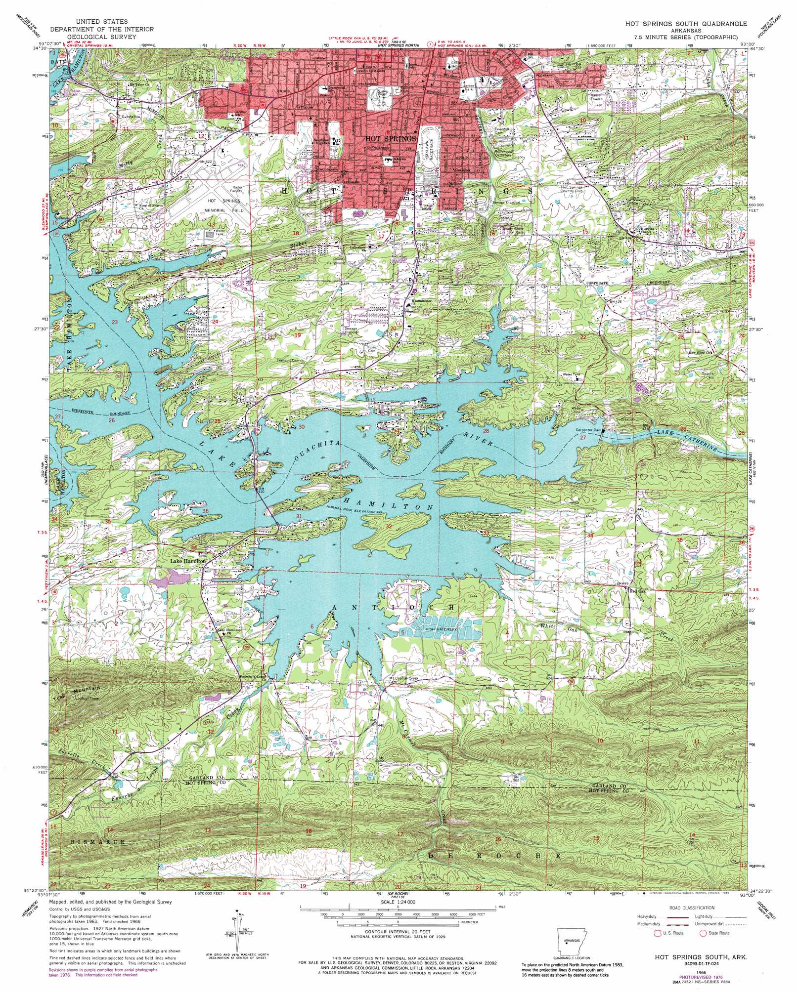
USGS Topo Quad 34093d1 - 1:24,000 scale
| Topo Map Name: | Hot Springs South |
| USGS Topo Quad ID: | 34093d1 |
| Print Size: | ca. 21 1/4" wide x 27" high |
| Southeast Coordinates: | 34.375° N latitude / 93° W longitude |
| Map Center Coordinates: | 34.4375° N latitude / 93.0625° W longitude |
| U.S. State: | AR |
| Filename: | o34093d1.jpg |
| Download Map JPG Image: | Hot Springs South topo map 1:24,000 scale |
| Map Type: | Topographic |
| Topo Series: | 7.5´ |
| Map Scale: | 1:24,000 |
| Source of Map Images: | United States Geological Survey (USGS) |
| Alternate Map Versions: |
Hot Springs South AR 1966, updated 1967 Download PDF Buy paper map Hot Springs South AR 1966, updated 1976 Download PDF Buy paper map Hot Springs South AR 1966, updated 1977 Download PDF Buy paper map Hot Springs South AR 1966, updated 1986 Download PDF Buy paper map Hot Springs South AR 1966, updated 1989 Download PDF Buy paper map Hot Springs South AR 2011 Download PDF Buy paper map Hot Springs South AR 2014 Download PDF Buy paper map |
1:24,000 Topo Quads surrounding Hot Springs South
Avant |
Hamilton |
Jessieville |
Goosepond Moutain |
Lonsdale Ne |
Crystal Springs |
Mountain Pine |
Hot Springs North |
Fountain Lake |
Lonsdale |
Pearcy |
Hempwallace |
Hot Springs South |
Lake Catherine |
Malvern North |
Point Cedar |
Bismark |
De Roche |
Social Hill |
Malvern South |
Chalybeate Mountain East |
De Gray |
Caddo Valley |
Donaldson |
Round Hill |
> Back to 34093a1 at 1:100,000 scale
> Back to 34092a1 at 1:250,000 scale
> Back to U.S. Topo Maps home
Hot Springs South topo map: Gazetteer
Hot Springs South: Airports
Higdon Field elevation 142m 465′Memorial Field elevation 156m 511′
Hot Springs South: Crossings
Browns Ferry (historical) elevation 136m 446′Higdon Ferry (historical) elevation 121m 396′
Kaiser Ferry (historical) elevation 121m 396′
Ralston Ferry (historical) elevation 120m 393′
Smiths Ferry (historical) elevation 119m 390′
Hot Springs South: Dams
Carpenter Dam elevation 121m 396′Hot Springs South: Parks
Family Park elevation 159m 521′Jaycee Park elevation 159m 521′
Kimberly Lane Park elevation 161m 528′
Hot Springs South: Populated Places
Lake Hamilton elevation 138m 452′Red Oak elevation 151m 495′
Hot Springs South: Reservoirs
Lake Hamilton elevation 107m 351′Hot Springs South: Streams
Fourche a Loupe Creek elevation 122m 400′Hot Springs Creek elevation 121m 396′
Molly Creek elevation 126m 413′
Mount Carmel Creek elevation 122m 400′
Sorrells Creek elevation 155m 508′
Stokes Creek elevation 123m 403′
White Oak Creek elevation 121m 396′
Hot Springs South: Summits
Trap Mountain elevation 402m 1318′Hot Springs South digital topo map on disk
Buy this Hot Springs South topo map showing relief, roads, GPS coordinates and other geographical features, as a high-resolution digital map file on DVD: