Hot Springs North Topo Map Arkansas
To zoom in, hover over the map of Hot Springs North
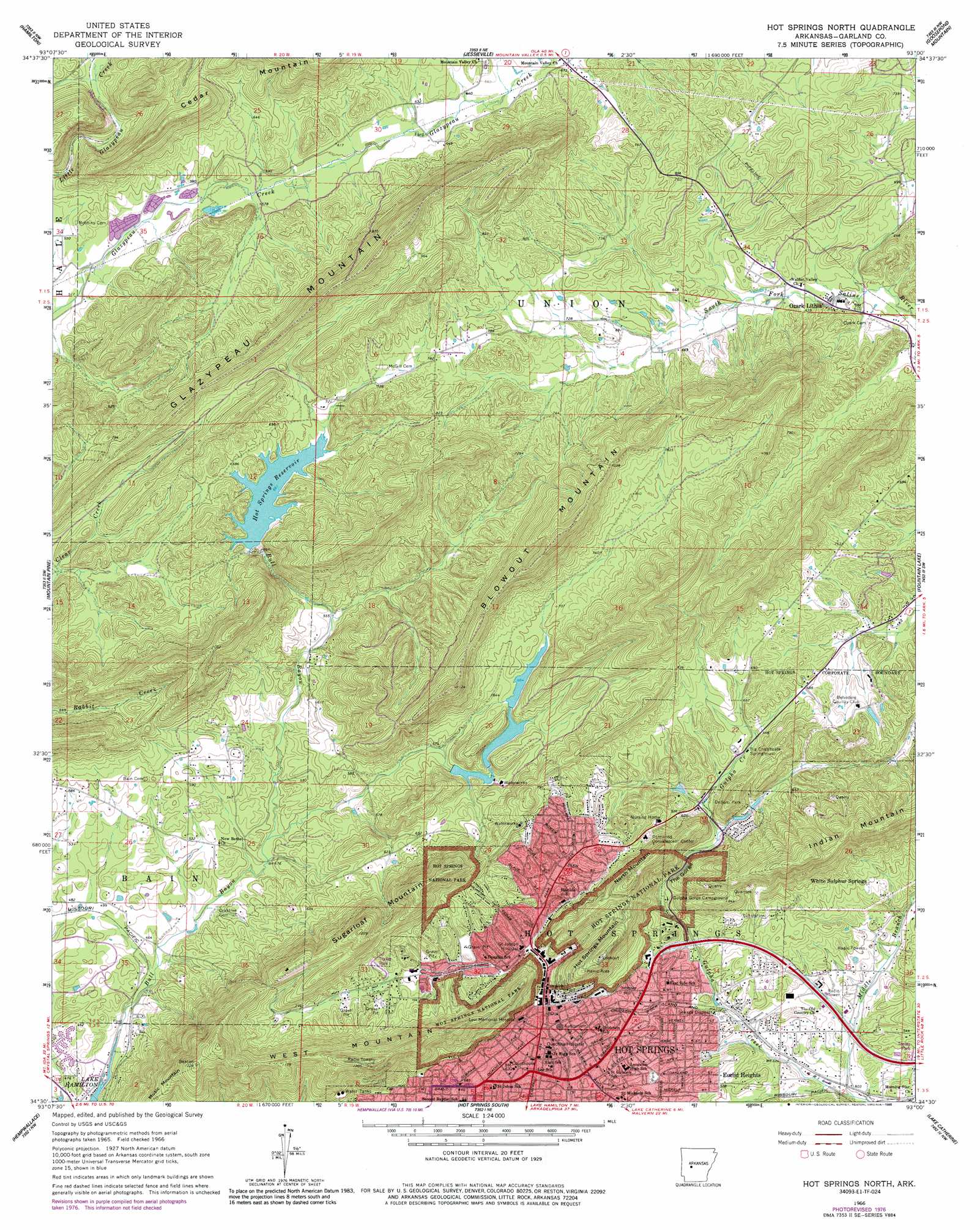
USGS Topo Quad 34093e1 - 1:24,000 scale
| Topo Map Name: | Hot Springs North |
| USGS Topo Quad ID: | 34093e1 |
| Print Size: | ca. 21 1/4" wide x 27" high |
| Southeast Coordinates: | 34.5° N latitude / 93° W longitude |
| Map Center Coordinates: | 34.5625° N latitude / 93.0625° W longitude |
| U.S. State: | AR |
| Filename: | o34093e1.jpg |
| Download Map JPG Image: | Hot Springs North topo map 1:24,000 scale |
| Map Type: | Topographic |
| Topo Series: | 7.5´ |
| Map Scale: | 1:24,000 |
| Source of Map Images: | United States Geological Survey (USGS) |
| Alternate Map Versions: |
Hot Springs North AR 1966, updated 1967 Download PDF Buy paper map Hot Springs North AR 1966, updated 1977 Download PDF Buy paper map Hot Springs North AR 1966, updated 1989 Download PDF Buy paper map Hot Springs North AR 1966, updated 1989 Download PDF Buy paper map Hot Springs North AR 2011 Download PDF Buy paper map Hot Springs North AR 2014 Download PDF Buy paper map |
| FStopo: | US Forest Service topo Hot Springs North is available: Download FStopo PDF Download FStopo TIF |
1:24,000 Topo Quads surrounding Hot Springs North
Steve |
Nimrod Sw |
Nimrod Se |
Paron Sw |
Paron |
Avant |
Hamilton |
Jessieville |
Goosepond Moutain |
Lonsdale Ne |
Crystal Springs |
Mountain Pine |
Hot Springs North |
Fountain Lake |
Lonsdale |
Pearcy |
Hempwallace |
Hot Springs South |
Lake Catherine |
Malvern North |
Point Cedar |
Bismark |
De Roche |
Social Hill |
Malvern South |
> Back to 34093e1 at 1:100,000 scale
> Back to 34092a1 at 1:250,000 scale
> Back to U.S. Topo Maps home
Hot Springs North topo map: Gazetteer
Hot Springs North: Dams
Belvedere Country Club Lake Dam elevation 229m 751′Bethel Dam elevation 182m 597′
Desoto Park Dam elevation 200m 656′
Dillon Dam elevation 186m 610′
Forest Lake Dam elevation 219m 718′
Lower Dam Number One elevation 209m 685′
Lower Dam Number Two elevation 182m 597′
Middle Dam elevation 182m 597′
Ricks Dam elevation 244m 800′
Ricks Estate Dam elevation 200m 656′
Sanderson Dam elevation 198m 649′
Upper Dam elevation 192m 629′
Hot Springs North: Parks
Bathhouse Row elevation 188m 616′Como Square elevation 186m 610′
DeSoto Park elevation 183m 600′
Gulpha Gorge Picnic Grounds elevation 164m 538′
Hot Springs Central Avenue Historical District elevation 187m 613′
Hot Springs National Park elevation 189m 620′
Linden Park elevation 294m 964′
Mid-America Park elevation 146m 479′
Wade Park elevation 176m 577′
Whittington Park elevation 222m 728′
Hot Springs North: Populated Places
Bonanza Springs (historical) elevation 171m 561′Euclid Heights elevation 155m 508′
Hot Springs elevation 178m 583′
Ozark Lithia elevation 184m 603′
Hot Springs North: Post Offices
Hot Springs Post Office elevation 185m 606′Hot Springs North: Reservoirs
Bethel Lake elevation 182m 597′Country Club Lake elevation 229m 751′
Desoto Lake elevation 200m 656′
Dillon Lake elevation 186m 610′
Forest Lake elevation 219m 718′
Hot Springs Reservoir elevation 206m 675′
Ricks Lake elevation 244m 800′
Ricks Pond elevation 209m 685′
Ricks Pond elevation 200m 656′
Sanderson Lake elevation 198m 649′
Sleepy Valley Lake elevation 192m 629′
Sleepy Valley Lower Lake elevation 182m 597′
Sleepy Valley Middle Lake elevation 182m 597′
Hot Springs North: Ridges
Glazypeau Mountain elevation 312m 1023′Music Mountain elevation 302m 990′
Hot Springs North: Springs
Big Chalybeate Spring elevation 192m 629′Whittington Spring elevation 210m 688′
Hot Springs North: Streams
Bull Bayou elevation 125m 410′Middle Branch Gulpha Creek elevation 120m 393′
Hot Springs North: Summits
Blowout Mountain elevation 379m 1243′Hot Springs Mountain elevation 315m 1033′
North Mountain elevation 344m 1128′
Sugarloaf Mountain elevation 348m 1141′
West Mountain elevation 433m 1420′
Hot Springs North: Valleys
The Gorge elevation 167m 547′Hot Springs North digital topo map on disk
Buy this Hot Springs North topo map showing relief, roads, GPS coordinates and other geographical features, as a high-resolution digital map file on DVD: