Crystal Springs Topo Map Arkansas
To zoom in, hover over the map of Crystal Springs
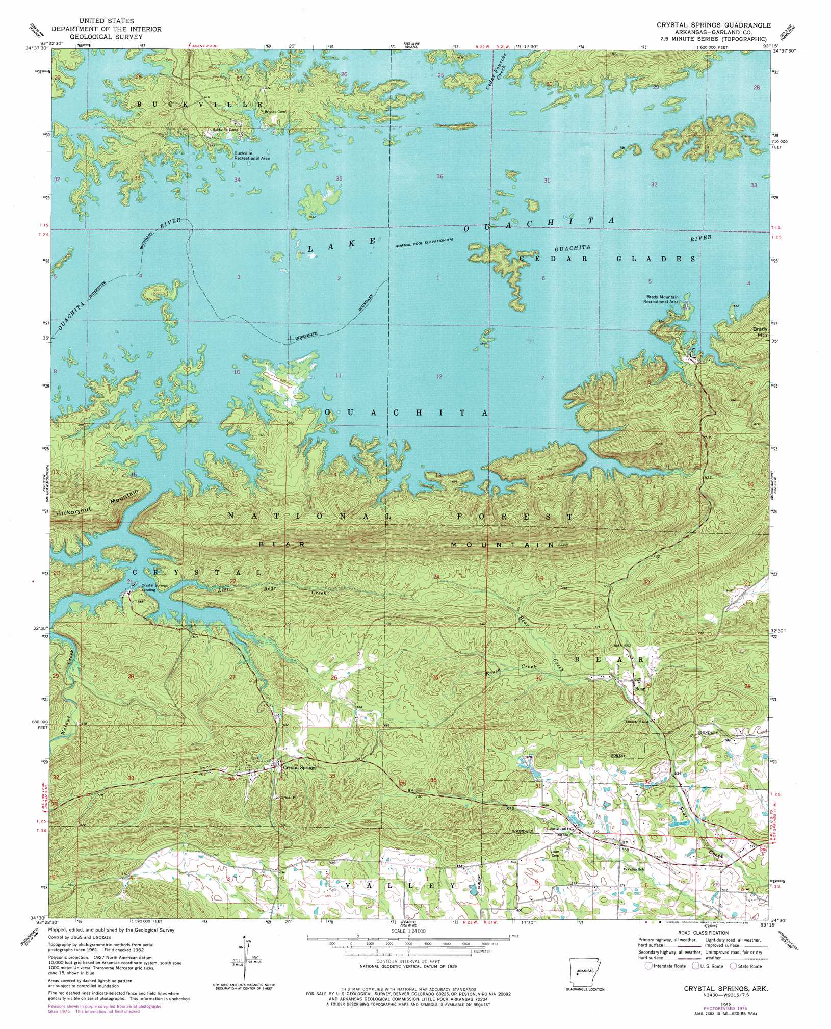
USGS Topo Quad 34093e3 - 1:24,000 scale
| Topo Map Name: | Crystal Springs |
| USGS Topo Quad ID: | 34093e3 |
| Print Size: | ca. 21 1/4" wide x 27" high |
| Southeast Coordinates: | 34.5° N latitude / 93.25° W longitude |
| Map Center Coordinates: | 34.5625° N latitude / 93.3125° W longitude |
| U.S. State: | AR |
| Filename: | o34093e3.jpg |
| Download Map JPG Image: | Crystal Springs topo map 1:24,000 scale |
| Map Type: | Topographic |
| Topo Series: | 7.5´ |
| Map Scale: | 1:24,000 |
| Source of Map Images: | United States Geological Survey (USGS) |
| Alternate Map Versions: |
Crystal Springs AR 1962, updated 1963 Download PDF Buy paper map Crystal Springs AR 1962, updated 1963 Download PDF Buy paper map Crystal Springs AR 1962, updated 1978 Download PDF Buy paper map Crystal Springs AR 1962, updated 1978 Download PDF Buy paper map Crystal Springs AR 2011 Download PDF Buy paper map Crystal Springs AR 2014 Download PDF Buy paper map |
| FStopo: | US Forest Service topo Crystal Springs is available: Download FStopo PDF Download FStopo TIF |
1:24,000 Topo Quads surrounding Crystal Springs
Chula Mountain |
Onyx |
Steve |
Nimrod Sw |
Nimrod Se |
Story |
Fannie |
Avant |
Hamilton |
Jessieville |
Reed Mountain |
Mcgraw Mountain |
Crystal Springs |
Mountain Pine |
Hot Springs North |
Caddo Gap |
Bonnerdale |
Pearcy |
Hempwallace |
Hot Springs South |
Glenwood |
Amity |
Point Cedar |
Bismark |
De Roche |
> Back to 34093e1 at 1:100,000 scale
> Back to 34092a1 at 1:250,000 scale
> Back to U.S. Topo Maps home
Crystal Springs topo map: Gazetteer
Crystal Springs: Dams
Arkansas Noname 136 Dam elevation 200m 656′Rector Lake Dam elevation 195m 639′
Crystal Springs: Parks
Brady Mountain Public Use Area elevation 181m 593′Buckville Public Use Area elevation 180m 590′
Crystal Springs Public Use Area elevation 182m 597′
Crystal Springs: Populated Places
Bear elevation 189m 620′Bucksville (historical) elevation 180m 590′
Cedar Glades (historical) elevation 174m 570′
Crystal Springs elevation 202m 662′
Crystal Springs Landing elevation 181m 593′
Crystal Springs: Reservoirs
Arkansas Noname 136 Reservoir elevation 200m 656′Rector Lake elevation 195m 639′
Crystal Springs: Ridges
Bear Mountain elevation 354m 1161′Crystal Springs: Streams
Cedar Fourche Creek elevation 174m 570′Little Bear Creek elevation 172m 564′
Rouse Creek elevation 200m 656′
Walnut Creek elevation 173m 567′
Crystal Springs digital topo map on disk
Buy this Crystal Springs topo map showing relief, roads, GPS coordinates and other geographical features, as a high-resolution digital map file on DVD: