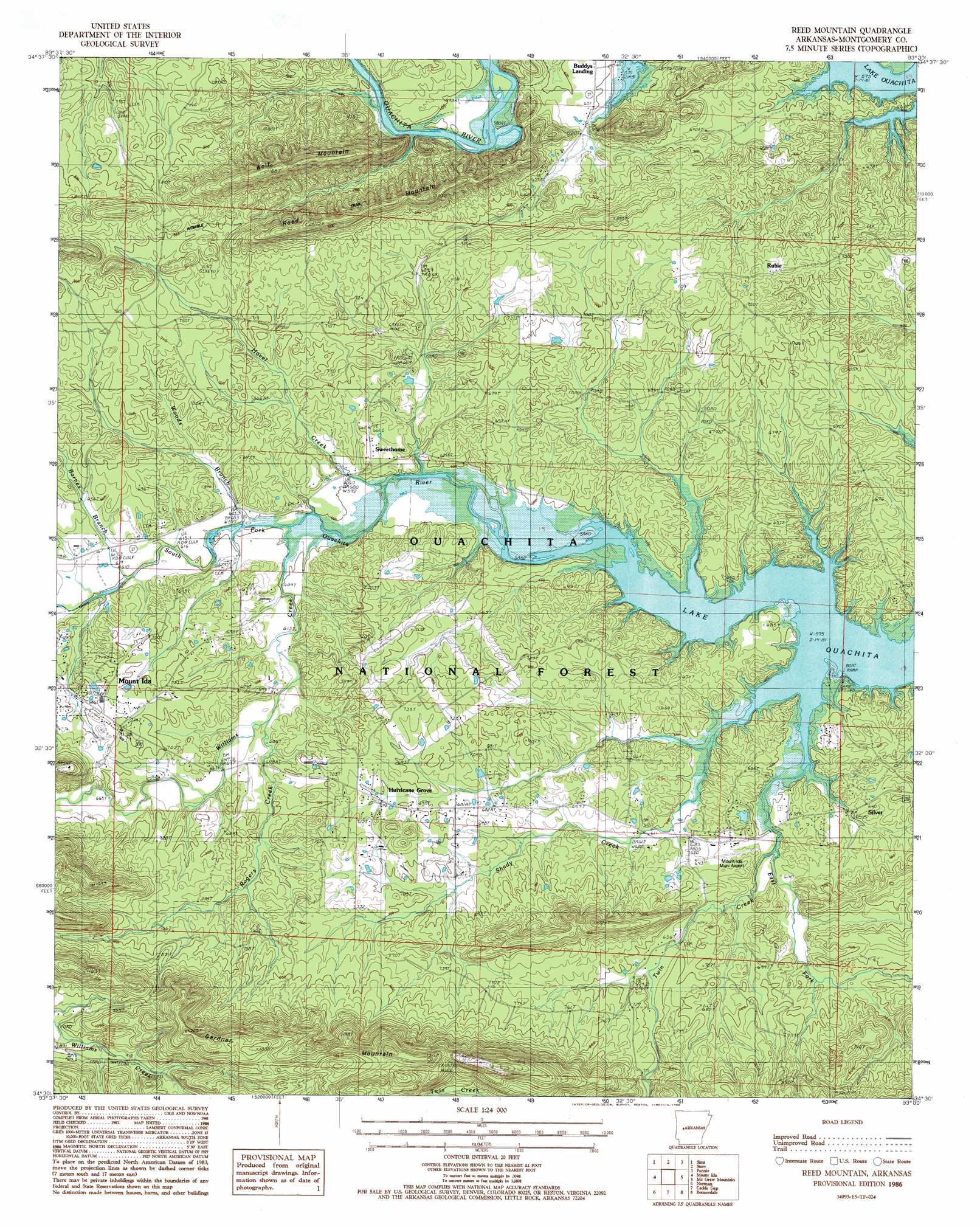
Reed Mountain Topo Map Arkansas
To zoom in, hover over the map of Reed Mountain
USGS Topo Quad 34093e5 - 1:24,000 scale
| Topo Map Name: | Reed Mountain |
| USGS Topo Quad ID: | 34093e5 |
| Print Size: | ca. 21 1/4" wide x 27" high |
| Southeast Coordinates: | 34.5° N latitude / 93.5° W longitude |
| Map Center Coordinates: | 34.5625° N latitude / 93.5625° W longitude |
| U.S. State: | AR |
| Filename: | o34093e5.jpg |
| Download Map JPG Image: | Reed Mountain topo map 1:24,000 scale |
| Map Type: | Topographic |
| Topo Series: | 7.5´ |
| Map Scale: | 1:24,000 |
| Source of Map Images: | United States Geological Survey (USGS) |
| Alternate Map Versions: |
Reed Mountain AR 1986, updated 1986 Download PDF Buy paper map Reed Mountain AR 2011 Download PDF Buy paper map Reed Mountain AR 2014 Download PDF Buy paper map |
| FStopo: | US Forest Service topo Reed Mountain is available: Download FStopo PDF Download FStopo TIF |
1:24,000 Topo Quads surrounding Reed Mountain
Harvey |
Little Texas |
Chula Mountain |
Onyx |
Steve |
Bushy Creek Mountain |
Sims |
Story |
Fannie |
Avant |
Oden |
Mount Ida |
Reed Mountain |
Mcgraw Mountain |
Crystal Springs |
Polk Creek Mountain |
Norman |
Caddo Gap |
Bonnerdale |
Pearcy |
Langley |
Lodi |
Glenwood |
Amity |
Point Cedar |
> Back to 34093e1 at 1:100,000 scale
> Back to 34092a1 at 1:250,000 scale
> Back to U.S. Topo Maps home
Reed Mountain topo map: Gazetteer
Reed Mountain: Airports
Bearce Airport elevation 192m 629′Mount Ida Municipal Airport elevation 193m 633′
Reed Mountain: Parks
Twin Creek Use Area elevation 179m 587′Reed Mountain: Populated Places
Buddys Landing elevation 179m 587′Hurricane Grove elevation 212m 695′
Rubie elevation 242m 793′
Ruble elevation 229m 751′
Silver elevation 185m 606′
Sweethome elevation 196m 643′
Reed Mountain: Ridges
Gardner Mountain elevation 389m 1276′Reed Mountain elevation 318m 1043′
Reed Mountain: Streams
Barnes Branch elevation 185m 606′East Fork Twin Creek elevation 183m 600′
Hovel Creek elevation 176m 577′
Rogers Creek elevation 190m 623′
Shady Creek elevation 175m 574′
South Fork Ouachita River elevation 186m 610′
Twin Creek elevation 174m 570′
Woods Branch elevation 182m 597′
Reed Mountain: Summits
Wolf Mountain elevation 359m 1177′Reed Mountain digital topo map on disk
Buy this Reed Mountain topo map showing relief, roads, GPS coordinates and other geographical features, as a high-resolution digital map file on DVD: