Jessieville Topo Map Arkansas
To zoom in, hover over the map of Jessieville
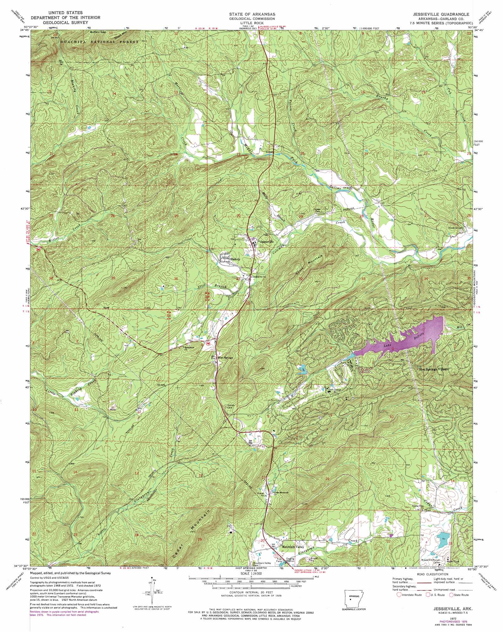
USGS Topo Quad 34093f1 - 1:24,000 scale
| Topo Map Name: | Jessieville |
| USGS Topo Quad ID: | 34093f1 |
| Print Size: | ca. 21 1/4" wide x 27" high |
| Southeast Coordinates: | 34.625° N latitude / 93° W longitude |
| Map Center Coordinates: | 34.6875° N latitude / 93.0625° W longitude |
| U.S. State: | AR |
| Filename: | o34093f1.jpg |
| Download Map JPG Image: | Jessieville topo map 1:24,000 scale |
| Map Type: | Topographic |
| Topo Series: | 7.5´ |
| Map Scale: | 1:24,000 |
| Source of Map Images: | United States Geological Survey (USGS) |
| Alternate Map Versions: |
Jessieville AR 1972, updated 1974 Download PDF Buy paper map Jessieville AR 1972, updated 1977 Download PDF Buy paper map Jessieville AR 2011 Download PDF Buy paper map Jessieville AR 2014 Download PDF Buy paper map |
| FStopo: | US Forest Service topo Jessieville is available: Download FStopo PDF Download FStopo TIF |
1:24,000 Topo Quads surrounding Jessieville
Plainview |
Nimrod Dam |
Nimrod |
Aplin |
Thornburg |
Steve |
Nimrod Sw |
Nimrod Se |
Paron Sw |
Paron |
Avant |
Hamilton |
Jessieville |
Goosepond Moutain |
Lonsdale Ne |
Crystal Springs |
Mountain Pine |
Hot Springs North |
Fountain Lake |
Lonsdale |
Pearcy |
Hempwallace |
Hot Springs South |
Lake Catherine |
Malvern North |
> Back to 34093e1 at 1:100,000 scale
> Back to 34092a1 at 1:250,000 scale
> Back to U.S. Topo Maps home
Jessieville topo map: Gazetteer
Jessieville: Dams
Big Lake Dam elevation 227m 744′Gross Lake Dam elevation 236m 774′
Hot Springs Dam Number One elevation 222m 728′
Hot Springs Dam Number Two elevation 244m 800′
Jessieville: Gaps
Buffalo Gap elevation 385m 1263′Jessieville: Populated Places
Blakely elevation 229m 751′Blue Springs elevation 236m 774′
Jessieville elevation 225m 738′
Lena (historical) elevation 239m 784′
Mountain Valley elevation 211m 692′
Jessieville: Reservoirs
Big Lake elevation 227m 744′Gross Lake elevation 236m 774′
Lake Desoto elevation 222m 728′
Lake Segovia elevation 244m 800′
Jessieville: Ridges
Cedar Mountain elevation 360m 1181′Jessieville: Streams
Baily Branch elevation 199m 652′Coleman Creek elevation 181m 593′
Cub Creek elevation 181m 593′
Merriott Creek elevation 211m 692′
Poison Creek elevation 201m 659′
Still Branch elevation 211m 692′
Jessieville: Summits
Short Mountain elevation 355m 1164′Jessieville digital topo map on disk
Buy this Jessieville topo map showing relief, roads, GPS coordinates and other geographical features, as a high-resolution digital map file on DVD: