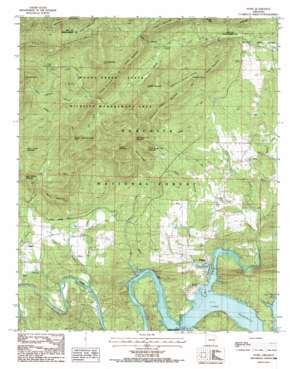
Story Topo Map Arkansas
To zoom in, hover over the map of Story
USGS Topo Quad 34093f5 - 1:24,000 scale
| Topo Map Name: | Story |
| USGS Topo Quad ID: | 34093f5 |
| Print Size: | ca. 21 1/4" wide x 27" high |
| Southeast Coordinates: | 34.625° N latitude / 93.5° W longitude |
| Map Center Coordinates: | 34.6875° N latitude / 93.5625° W longitude |
| U.S. State: | AR |
| Filename: | o34093f5.jpg |
| Download Map JPG Image: | Story topo map 1:24,000 scale |
| Map Type: | Topographic |
| Topo Series: | 7.5´ |
| Map Scale: | 1:24,000 |
| Source of Map Images: | United States Geological Survey (USGS) |
| Alternate Map Versions: |
Story AR 1986, updated 1986 Download PDF Buy paper map Story AR 2011 Download PDF Buy paper map Story AR 2014 Download PDF Buy paper map |
| FStopo: | US Forest Service topo Story is available: Download FStopo PDF Download FStopo TIF |
1:24,000 Topo Quads surrounding Story
> Back to 34093e1 at 1:100,000 scale
> Back to 34092a1 at 1:250,000 scale
> Back to U.S. Topo Maps home
Story topo map: Gazetteer
Story: Populated Places
Gibbs elevation 206m 675′Story elevation 215m 705′
Washita elevation 186m 610′
Story: Post Offices
Story Post Office elevation 214m 702′Story: Ridges
Chalybeate Mountain elevation 412m 1351′Harold Ridge elevation 366m 1200′
Muddy Mountain elevation 532m 1745′
Story: Springs
Chalybeate Spring elevation 270m 885′Story: Streams
Bear Cave Prong elevation 300m 984′Bear Wallow Prong elevation 300m 984′
Big Branch elevation 177m 580′
Deer Creek elevation 172m 564′
Dry Fork elevation 292m 958′
Haw Branch elevation 179m 587′
House Branch elevation 190m 623′
Mill Iron Creek elevation 183m 600′
Muddy Creek elevation 191m 626′
Qualls Creek elevation 206m 675′
Right Prong Muddy Creek elevation 270m 885′
Rocky Creek elevation 190m 623′
Story Creek elevation 184m 603′
Wheat Creek elevation 178m 583′
Story: Summits
Big Round Top Mountain elevation 459m 1505′Brantley Mountain elevation 504m 1653′
Brushy Mountain elevation 372m 1220′
Carely Mountain elevation 406m 1332′
Jeff Summit Mountain elevation 337m 1105′
Kelly Mountain elevation 423m 1387′
Little Round Top Mountain elevation 384m 1259′
McGill Mountain elevation 383m 1256′
Owens Mountain elevation 497m 1630′
Phillips Mountain elevation 327m 1072′
Pot Mountain elevation 472m 1548′
Procter Mountain elevation 365m 1197′
Rainy Creek Mountain elevation 375m 1230′
Rainy Mountain elevation 348m 1141′
Rocky Creek Mountain elevation 444m 1456′
Round Mountain elevation 396m 1299′
Suck Mountain elevation 455m 1492′
Thorpe Mountain elevation 416m 1364′
Story: Valleys
Chalybeate Spring Hollow elevation 268m 879′Story digital topo map on disk
Buy this Story topo map showing relief, roads, GPS coordinates and other geographical features, as a high-resolution digital map file on DVD:


