Parks Topo Map Arkansas
To zoom in, hover over the map of Parks
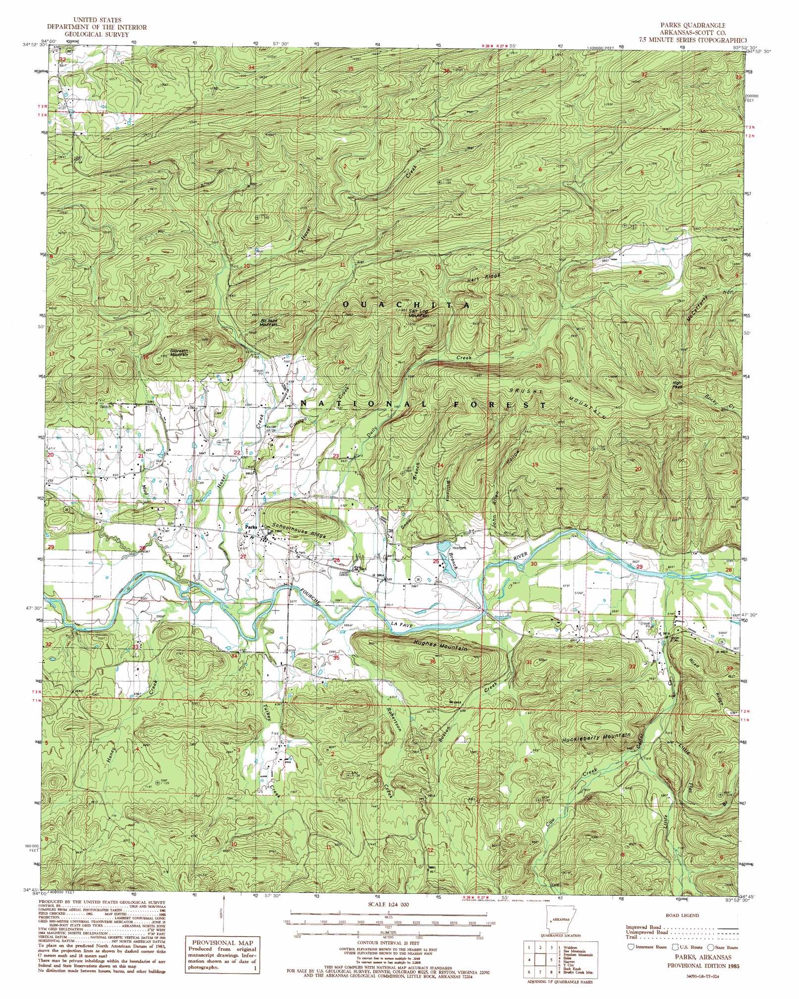
USGS Topo Quad 34093g8 - 1:24,000 scale
| Topo Map Name: | Parks |
| USGS Topo Quad ID: | 34093g8 |
| Print Size: | ca. 21 1/4" wide x 27" high |
| Southeast Coordinates: | 34.75° N latitude / 93.875° W longitude |
| Map Center Coordinates: | 34.8125° N latitude / 93.9375° W longitude |
| U.S. State: | AR |
| Filename: | o34093g8.jpg |
| Download Map JPG Image: | Parks topo map 1:24,000 scale |
| Map Type: | Topographic |
| Topo Series: | 7.5´ |
| Map Scale: | 1:24,000 |
| Source of Map Images: | United States Geological Survey (USGS) |
| Alternate Map Versions: |
Parks AR 1985, updated 1986 Download PDF Buy paper map Parks AR 2011 Download PDF Buy paper map Parks AR 2014 Download PDF Buy paper map |
| FStopo: | US Forest Service topo Parks is available: Download FStopo PDF Download FStopo TIF |
1:24,000 Topo Quads surrounding Parks
Abbott |
Ione |
Golden City |
Sugar Grove |
Blue Mountain Dam |
Hon |
Waldron |
Bee Mountain |
Freedom Mountain |
Gravelly |
Peanut Mountain |
Boles |
Parks |
Harvey |
Little Texas |
Acorn |
Y City |
Buck Knob |
Bushy Creek Mountain |
Sims |
Mena |
Board Camp |
Pine Ridge |
Oden |
Mount Ida |
> Back to 34093e1 at 1:100,000 scale
> Back to 34092a1 at 1:250,000 scale
> Back to U.S. Topo Maps home
Parks topo map: Gazetteer
Parks: Populated Places
Parks elevation 197m 646′Parks: Post Offices
Parks Post Office elevation 197m 646′Parks: Ridges
Brushy Mountain elevation 361m 1184′Hart Ridge elevation 338m 1108′
Parks: Streams
Boston Creek elevation 175m 574′Catalpa Creek elevation 200m 656′
Cow Creek elevation 197m 646′
Daily Creek elevation 179m 587′
Haney Creek elevation 174m 570′
Hazel Creek elevation 177m 580′
Little Cedar Creek elevation 166m 544′
Little Flat Branch elevation 190m 623′
Mud Creek elevation 181m 593′
Robertson Creek elevation 172m 564′
Snow Branch elevation 178m 583′
Turkey Creek elevation 176m 577′
Williams Branch elevation 171m 561′
Parks: Summits
Bill Hunt Mountain elevation 298m 977′Gilbreath Mountain elevation 307m 1007′
High Peak elevation 378m 1240′
Huckleberry Mountain elevation 312m 1023′
Hughes Mountain elevation 286m 938′
Salt Log Mountain elevation 366m 1200′
Schoolhouse Ridge elevation 257m 843′
Parks: Valleys
John Allen Hollow elevation 171m 561′Parks digital topo map on disk
Buy this Parks topo map showing relief, roads, GPS coordinates and other geographical features, as a high-resolution digital map file on DVD: