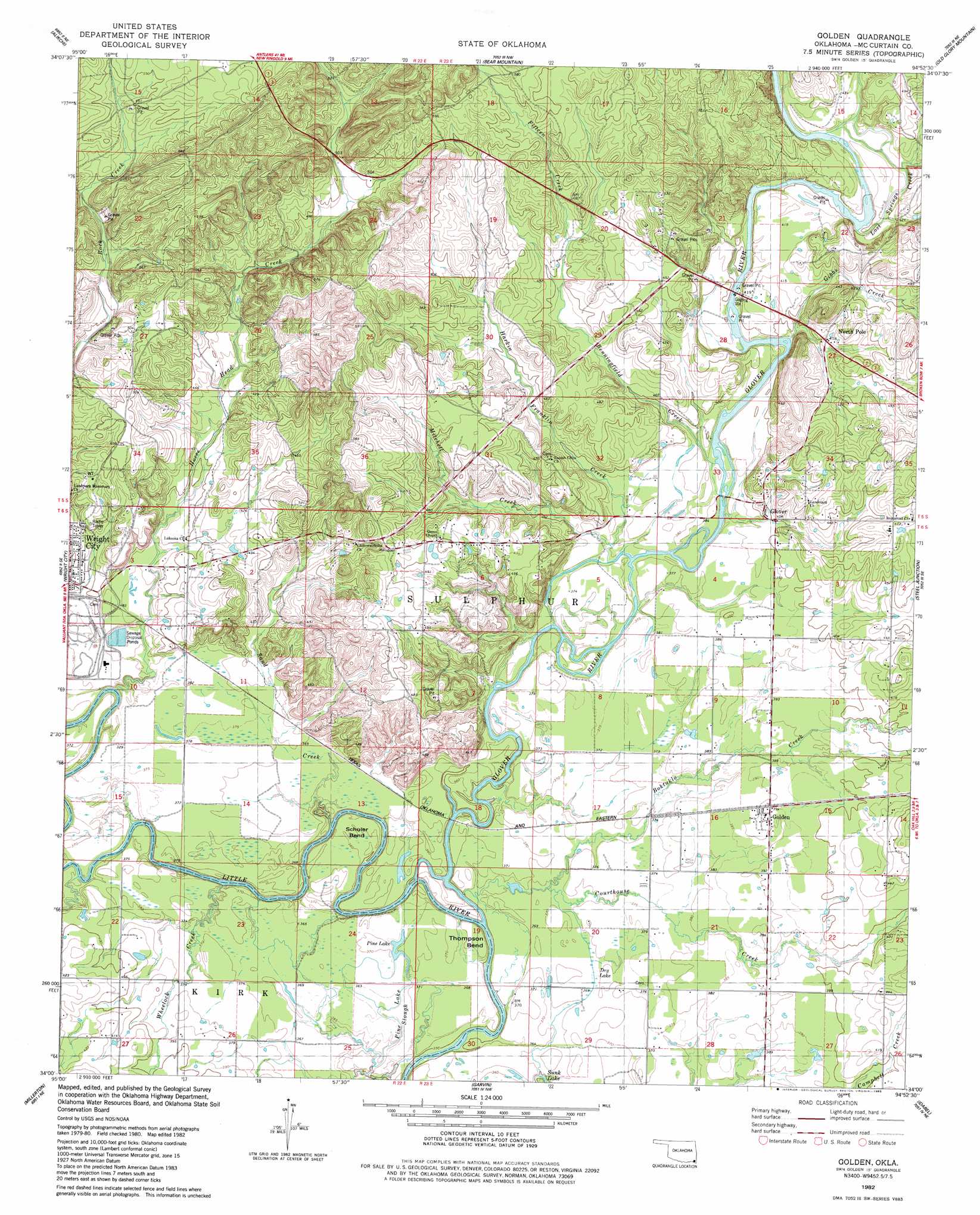
Golden Topo Map Oklahoma
To zoom in, hover over the map of Golden
USGS Topo Quad 34094a8 - 1:24,000 scale
| Topo Map Name: | Golden |
| USGS Topo Quad ID: | 34094a8 |
| Print Size: | ca. 21 1/4" wide x 27" high |
| Southeast Coordinates: | 34° N latitude / 94.875° W longitude |
| Map Center Coordinates: | 34.0625° N latitude / 94.9375° W longitude |
| U.S. State: | OK |
| Filename: | o34094a8.jpg |
| Download Map JPG Image: | Golden topo map 1:24,000 scale |
| Map Type: | Topographic |
| Topo Series: | 7.5´ |
| Map Scale: | 1:24,000 |
| Source of Map Images: | United States Geological Survey (USGS) |
| Alternate Map Versions: |
Golden OK 1982, updated 1983 Download PDF Buy paper map Golden OK 2010 Download PDF Buy paper map Golden OK 2012 Download PDF Buy paper map Golden OK 2016 Download PDF Buy paper map |
1:24,000 Topo Quads surrounding Golden
Caney Mountain |
Signal Mountain |
Rockey Creek |
Bethel |
Hee Creek |
Sobol |
Alikchi |
Bear Mountain |
Old Glory Mountain |
Stephens Gap |
Swink |
Wright City |
Golden |
Steel Junction |
Broken Bow |
Kiomatia |
Millerton |
Garvin |
Idabel |
Shults |
Manchester |
Negley |
Acworth |
Idabel Se |
Haworth |
> Back to 34094a1 at 1:100,000 scale
> Back to 34094a1 at 1:250,000 scale
> Back to U.S. Topo Maps home
Golden topo map: Gazetteer
Golden: Bends
Schuler Bend elevation 110m 360′Shuler Bend elevation 110m 360′
Thompson Bend elevation 114m 374′
Golden: Lakes
Dry Lake elevation 113m 370′Pine Lake elevation 113m 370′
Golden: Populated Places
Glover elevation 122m 400′Golden elevation 120m 393′
North Pole elevation 125m 410′
Golden: Streams
Benningfield Creek elevation 115m 377′Colbert Creek elevation 122m 400′
Courthouse Creek elevation 110m 360′
Fifteen Creek elevation 139m 456′
Gibbs Creek elevation 115m 377′
Glover River elevation 105m 344′
Harkin Franklin Creek elevation 112m 367′
Horse Head Creek elevation 110m 360′
Lost Springs Creek elevation 125m 410′
Martin Creek elevation 111m 364′
Mitchell Creek elevation 112m 367′
Pine Lake Slough elevation 112m 367′
Sand Creek elevation 106m 347′
South Boktuklo Creek elevation 106m 347′
Wheelock Creek elevation 105m 344′
Golden digital topo map on disk
Buy this Golden topo map showing relief, roads, GPS coordinates and other geographical features, as a high-resolution digital map file on DVD: