Dierks Dam Topo Map Arkansas
To zoom in, hover over the map of Dierks Dam
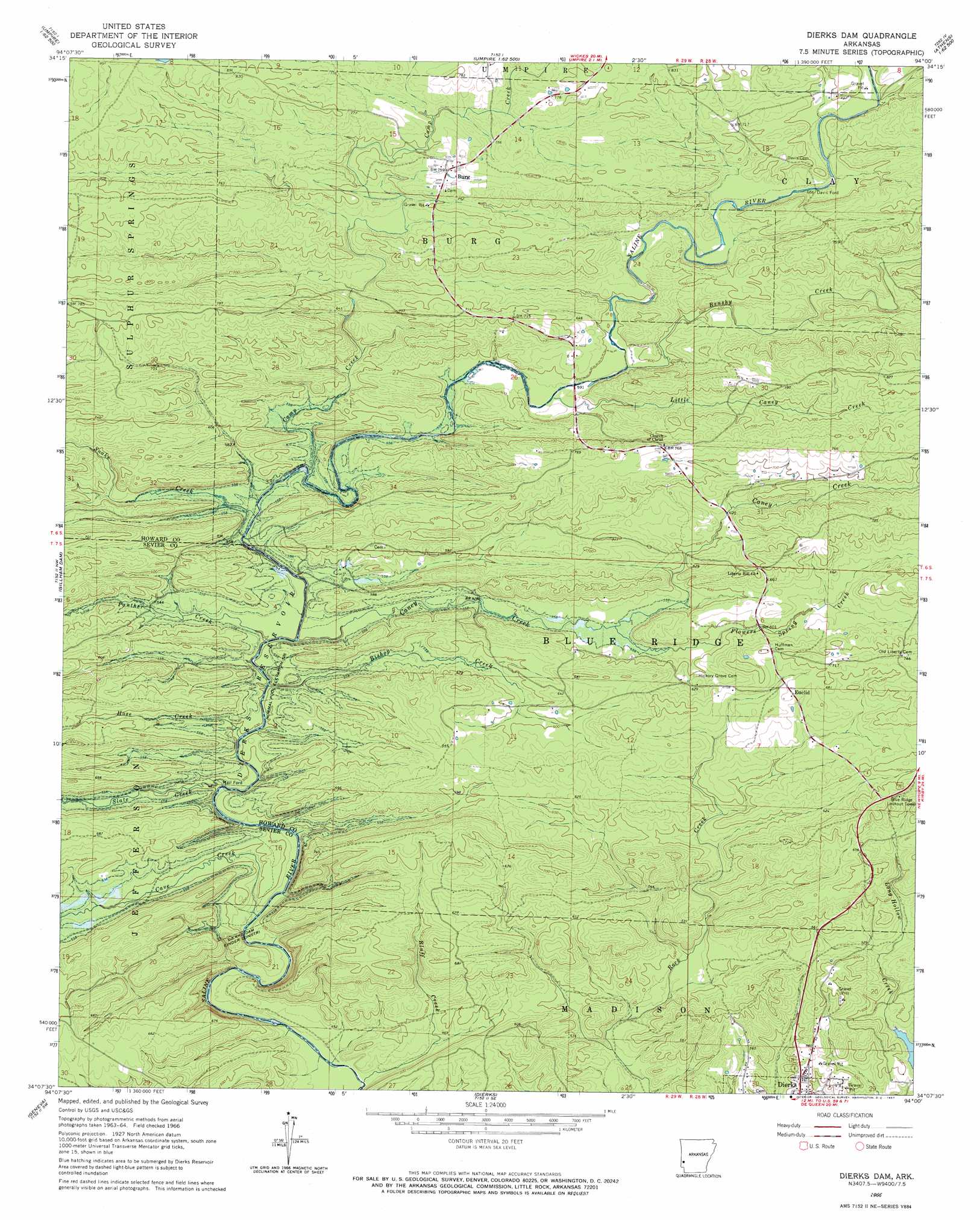
USGS Topo Quad 34094b1 - 1:24,000 scale
| Topo Map Name: | Dierks Dam |
| USGS Topo Quad ID: | 34094b1 |
| Print Size: | ca. 21 1/4" wide x 27" high |
| Southeast Coordinates: | 34.125° N latitude / 94° W longitude |
| Map Center Coordinates: | 34.1875° N latitude / 94.0625° W longitude |
| U.S. State: | AR |
| Filename: | o34094b1.jpg |
| Download Map JPG Image: | Dierks Dam topo map 1:24,000 scale |
| Map Type: | Topographic |
| Topo Series: | 7.5´ |
| Map Scale: | 1:24,000 |
| Source of Map Images: | United States Geological Survey (USGS) |
| Alternate Map Versions: |
Dierks Dam AR 1966, updated 1967 Download PDF Buy paper map Dierks Dam AR 2011 Download PDF Buy paper map Dierks Dam AR 2014 Download PDF Buy paper map |
1:24,000 Topo Quads surrounding Dierks Dam
Vandervoort |
Eagle Mountain |
Nichols Nountain |
Big Fork |
Polk Creek Mountain |
Wickes |
Baker Springs |
Umpire |
Athens |
Langley |
Gillham |
Gillham Dam |
Dierks Dam |
Newhope |
Center Point Ne |
De Queen |
Geneva |
Dierks |
Center Point |
Nathan |
Horatio |
Lockesburg |
Silver Ridge |
Mineral Springs North |
Nashville |
> Back to 34094a1 at 1:100,000 scale
> Back to 34094a1 at 1:250,000 scale
> Back to U.S. Topo Maps home
Dierks Dam topo map: Gazetteer
Dierks Dam: Crossings
Flowers Mill Crossing elevation 127m 416′Potts Ford (historical) elevation 160m 524′
Thompson Ford (historical) elevation 160m 524′
Dierks Dam: Dams
Dierks Dam elevation 161m 528′Dierks Dam: Parks
Blue Ridge Use Area elevation 167m 547′Horseshoe Bend Use Area elevation 152m 498′
Dierks Dam: Populated Places
Burg elevation 228m 748′Davis Ford elevation 201m 659′
Euclid elevation 210m 688′
Old Euclid (historical) elevation 181m 593′
Oreb (historical) elevation 205m 672′
Rough Edge (historical) elevation 211m 692′
Dierks Dam: Reservoirs
Dierks Lake elevation 150m 492′Dierks Dam: Springs
Flowers Spring elevation 165m 541′Dierks Dam: Streams
Amos Branch elevation 210m 688′Bishop Creek elevation 160m 524′
Bluff Creek elevation 126m 413′
Brushy Creek elevation 178m 583′
Camp Creek elevation 158m 518′
Caney Creek elevation 175m 574′
Cave Creek elevation 161m 528′
Flowers Spring Creek elevation 182m 597′
Hose Creek elevation 161m 528′
Little Caney Creek elevation 174m 570′
Long Hollow Creek elevation 127m 416′
Panther Creek elevation 159m 521′
Slate Creek elevation 161m 528′
Snake Creek elevation 158m 518′
Dierks Dam digital topo map on disk
Buy this Dierks Dam topo map showing relief, roads, GPS coordinates and other geographical features, as a high-resolution digital map file on DVD: