Umpire Topo Map Arkansas
To zoom in, hover over the map of Umpire
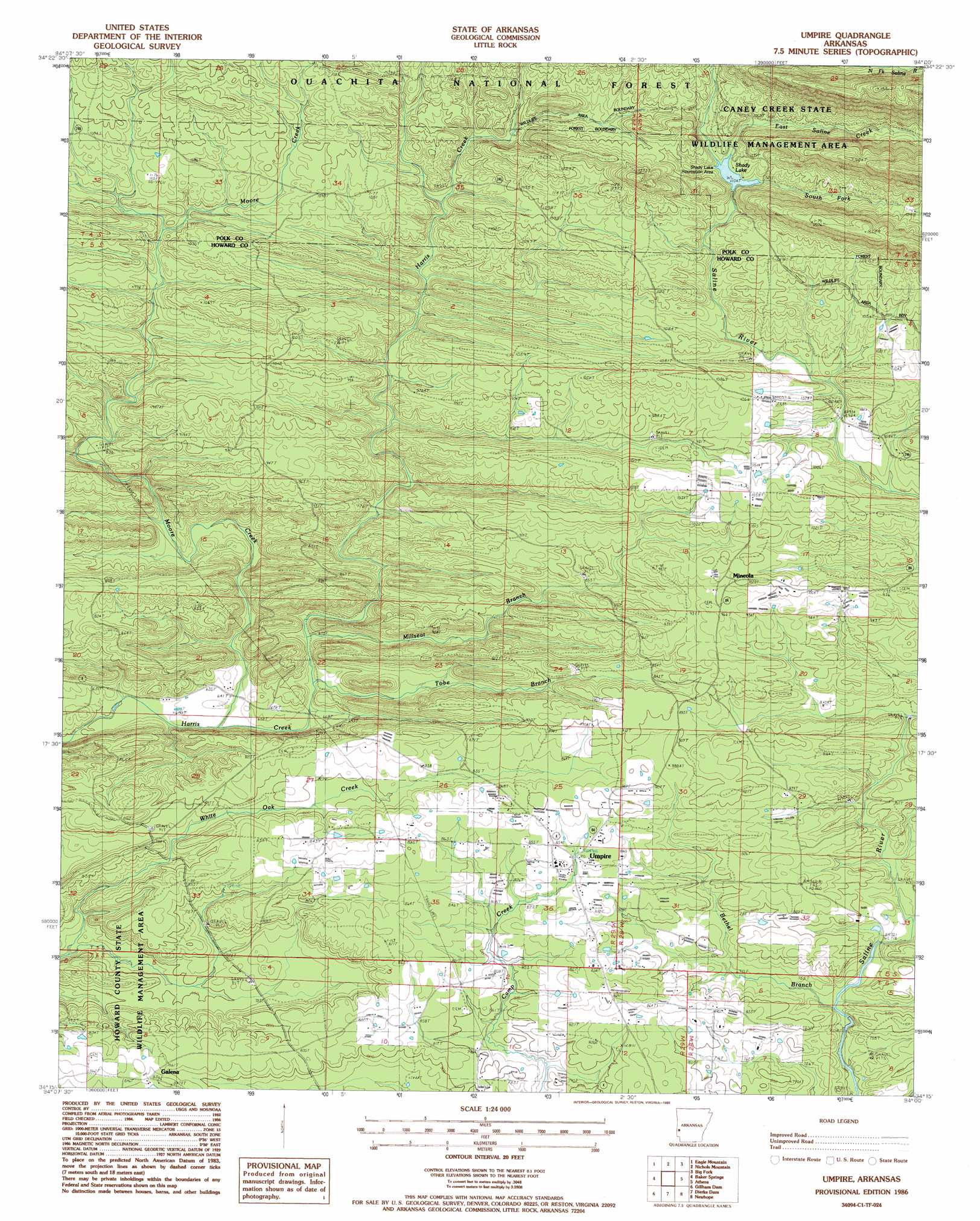
USGS Topo Quad 34094c1 - 1:24,000 scale
| Topo Map Name: | Umpire |
| USGS Topo Quad ID: | 34094c1 |
| Print Size: | ca. 21 1/4" wide x 27" high |
| Southeast Coordinates: | 34.25° N latitude / 94° W longitude |
| Map Center Coordinates: | 34.3125° N latitude / 94.0625° W longitude |
| U.S. State: | AR |
| Filename: | o34094c1.jpg |
| Download Map JPG Image: | Umpire topo map 1:24,000 scale |
| Map Type: | Topographic |
| Topo Series: | 7.5´ |
| Map Scale: | 1:24,000 |
| Source of Map Images: | United States Geological Survey (USGS) |
| Alternate Map Versions: |
Umpire AR 1986, updated 1986 Download PDF Buy paper map Umpire AR 1986, updated 1986 Download PDF Buy paper map Umpire AR 2011 Download PDF Buy paper map Umpire AR 2014 Download PDF Buy paper map |
| FStopo: | US Forest Service topo Umpire is available: Download FStopo PDF Download FStopo TIF |
1:24,000 Topo Quads surrounding Umpire
Potter |
Mena |
Board Camp |
Pine Ridge |
Oden |
Vandervoort |
Eagle Mountain |
Nichols Nountain |
Big Fork |
Polk Creek Mountain |
Wickes |
Baker Springs |
Umpire |
Athens |
Langley |
Gillham |
Gillham Dam |
Dierks Dam |
Newhope |
Center Point Ne |
De Queen |
Geneva |
Dierks |
Center Point |
Nathan |
> Back to 34094a1 at 1:100,000 scale
> Back to 34094a1 at 1:250,000 scale
> Back to U.S. Topo Maps home
Umpire topo map: Gazetteer
Umpire: Dams
Shady Lake Dam elevation 331m 1085′Umpire: Lakes
Shady Lake elevation 340m 1115′Umpire: Parks
Shady Lake Recreation Area elevation 344m 1128′Umpire: Populated Places
Battle Hill (historical) elevation 235m 770′Bethel (historical) elevation 243m 797′
Bluff Springs (historical) elevation 255m 836′
Cedar Hill (historical) elevation 251m 823′
Dial (historical) elevation 266m 872′
Faulkner Springs elevation 288m 944′
Galena elevation 260m 853′
Midway (historical) elevation 323m 1059′
Mineola elevation 305m 1000′
Mouton (historical) elevation 270m 885′
New Moon (historical) elevation 297m 974′
Old Union (historical) elevation 306m 1003′
Saline (historical) elevation 323m 1059′
Umpire elevation 258m 846′
Umpire: Post Offices
Umpire Post Office elevation 257m 843′Umpire: Reservoirs
Shady Lake elevation 331m 1085′Umpire: Streams
Bethel Branch elevation 217m 711′East Saline Creek elevation 335m 1099′
Millseat Branch elevation 209m 685′
Moore Creek elevation 191m 626′
South Fork Saline River elevation 340m 1115′
Tobe Branch elevation 203m 666′
Umpire digital topo map on disk
Buy this Umpire topo map showing relief, roads, GPS coordinates and other geographical features, as a high-resolution digital map file on DVD: