Hee Creek Topo Map Oklahoma
To zoom in, hover over the map of Hee Creek
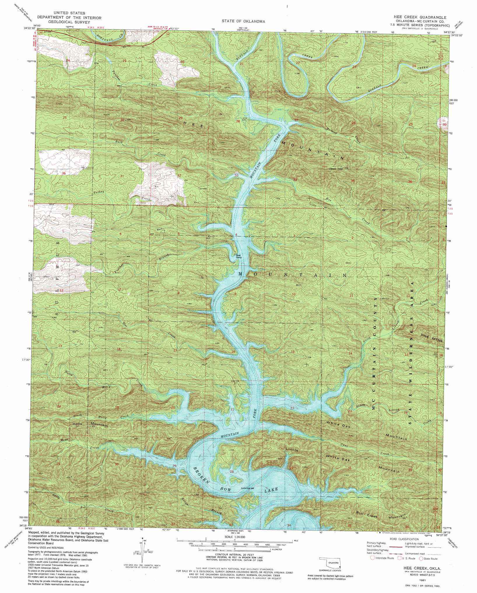
USGS Topo Quad 34094c6 - 1:24,000 scale
| Topo Map Name: | Hee Creek |
| USGS Topo Quad ID: | 34094c6 |
| Print Size: | ca. 21 1/4" wide x 27" high |
| Southeast Coordinates: | 34.25° N latitude / 94.625° W longitude |
| Map Center Coordinates: | 34.3125° N latitude / 94.6875° W longitude |
| U.S. State: | OK |
| Filename: | o34094c6.jpg |
| Download Map JPG Image: | Hee Creek topo map 1:24,000 scale |
| Map Type: | Topographic |
| Topo Series: | 7.5´ |
| Map Scale: | 1:24,000 |
| Source of Map Images: | United States Geological Survey (USGS) |
| Alternate Map Versions: |
Hee Creek OK 1981, updated 1981 Download PDF Buy paper map Hee Creek OK 2010 Download PDF Buy paper map Hee Creek OK 2013 Download PDF Buy paper map Hee Creek OK 2016 Download PDF Buy paper map |
| FStopo: | US Forest Service topo Hee Creek is available: Download FStopo PDF Download FStopo TIF |
1:24,000 Topo Quads surrounding Hee Creek
Honobia |
Ludlow |
Octavia |
Lynn Mountain |
Zafra |
Battiest |
White Rock Mountain |
Smithville |
Watson |
Cove |
Rockey Creek |
Bethel |
Hee Creek |
Big Hudson Creek |
Bog Springs |
Bear Mountain |
Old Glory Mountain |
Stephens Gap |
Toblerville |
De Queen Nw |
Golden |
Steel Junction |
Broken Bow |
Eagletown |
Chapel Hill |
> Back to 34094a1 at 1:100,000 scale
> Back to 34094a1 at 1:250,000 scale
> Back to U.S. Topo Maps home
Hee Creek topo map: Gazetteer
Hee Creek: Parks
McCurtain County Game Reserve elevation 237m 777′Hee Creek: Streams
Bear Creek elevation 183m 600′Buck Creek elevation 183m 600′
Buffalo Creek elevation 183m 600′
Cane Creek elevation 183m 600′
Gar Creek elevation 183m 600′
Hee Creek elevation 183m 600′
Holly Creek elevation 183m 600′
Hudson Creek elevation 183m 600′
Linson Creek elevation 183m 600′
North Holly Creek elevation 183m 600′
North Linson Creek elevation 183m 600′
Panther Branch elevation 183m 600′
Panther Creek elevation 183m 600′
South Holly Creek elevation 184m 603′
South Linson Creek elevation 183m 600′
Turkey Creek elevation 183m 600′
Hee Creek: Summits
Bull Creek Mountain elevation 309m 1013′Hee Mountain elevation 397m 1302′
Holly Mountain elevation 255m 836′
Little White Oak Mountain elevation 292m 958′
Hee Creek digital topo map on disk
Buy this Hee Creek topo map showing relief, roads, GPS coordinates and other geographical features, as a high-resolution digital map file on DVD: