Peanut Mountain Topo Map Arkansas
To zoom in, hover over the map of Peanut Mountain
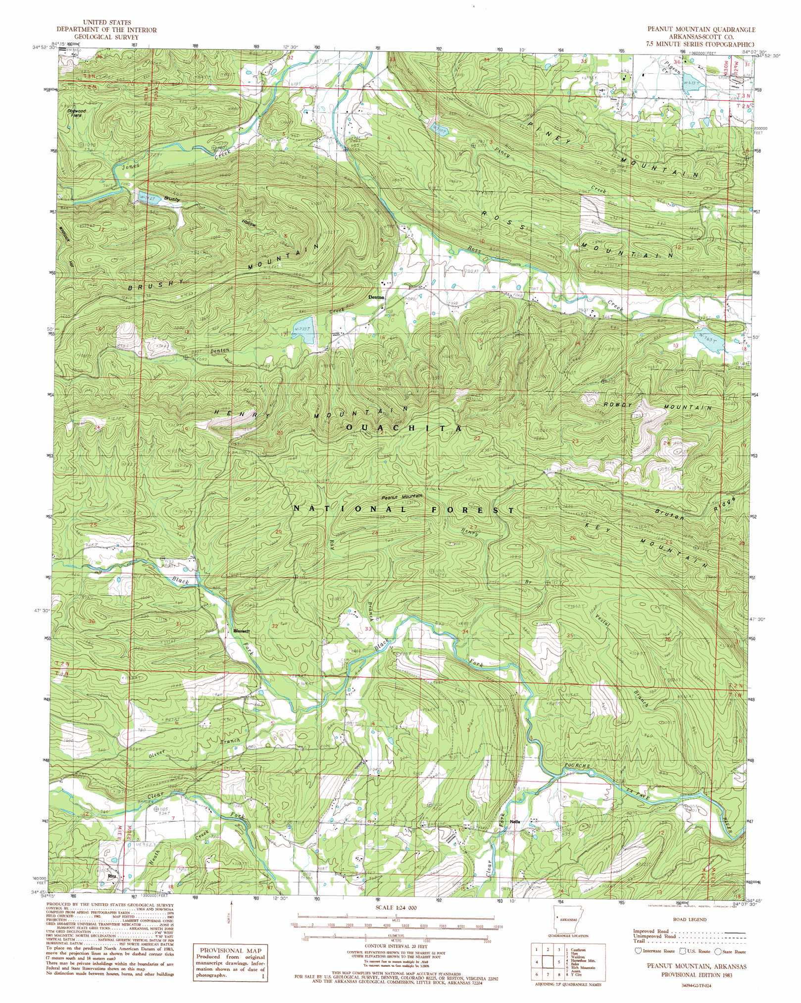
USGS Topo Quad 34094g2 - 1:24,000 scale
| Topo Map Name: | Peanut Mountain |
| USGS Topo Quad ID: | 34094g2 |
| Print Size: | ca. 21 1/4" wide x 27" high |
| Southeast Coordinates: | 34.75° N latitude / 94.125° W longitude |
| Map Center Coordinates: | 34.8125° N latitude / 94.1875° W longitude |
| U.S. State: | AR |
| Filename: | o34094g2.jpg |
| Download Map JPG Image: | Peanut Mountain topo map 1:24,000 scale |
| Map Type: | Topographic |
| Topo Series: | 7.5´ |
| Map Scale: | 1:24,000 |
| Source of Map Images: | United States Geological Survey (USGS) |
| Alternate Map Versions: |
Peanut Mountain AR 1983, updated 1984 Download PDF Buy paper map Peanut Mountain AR 2011 Download PDF Buy paper map Peanut Mountain AR 2014 Download PDF Buy paper map |
| FStopo: | US Forest Service topo Peanut Mountain is available: Download FStopo PDF Download FStopo TIF |
1:24,000 Topo Quads surrounding Peanut Mountain
Hartford |
Huntington |
Abbott |
Ione |
Golden City |
Bates |
Cauthron |
Hon |
Waldron |
Bee Mountain |
Loving |
Horseshoe Mountain |
Peanut Mountain |
Boles |
Parks |
Mountain Fork |
Rich Mountain |
Acorn |
Y City |
Buck Knob |
Zafra |
Potter |
Mena |
Board Camp |
Pine Ridge |
> Back to 34094e1 at 1:100,000 scale
> Back to 34094a1 at 1:250,000 scale
> Back to U.S. Topo Maps home
Peanut Mountain topo map: Gazetteer
Peanut Mountain: Dams
Giles Lake Dam elevation 205m 672′Poteau River Watershed Site 14 Dam elevation 232m 761′
Poteau River Watershed Site 17 Dam elevation 232m 761′
Poteau River Watershed Site 18 Dam elevation 233m 764′
Peanut Mountain: Flats
Dogwood Flats elevation 238m 780′Peanut Mountain: Populated Places
Blansett elevation 272m 892′Denton elevation 224m 734′
Nella elevation 258m 846′
Ritz elevation 297m 974′
Shiloh elevation 269m 882′
Peanut Mountain: Reservoirs
Giles Pond elevation 205m 672′Poteau River Site 14 Lake elevation 232m 761′
Poteau River Site 17 Lake elevation 232m 761′
Poteau River Site 18 Lake elevation 233m 764′
Peanut Mountain: Ridges
Brushy Mountain elevation 378m 1240′Bruton Ridge elevation 336m 1102′
Henry Mountain elevation 379m 1243′
Peanut Mountain: Streams
Black Fork elevation 246m 807′Clear Fork elevation 246m 807′
Denton Creek elevation 212m 695′
Heath Creek elevation 275m 902′
Henry Branch elevation 247m 810′
Oliver Branch elevation 258m 846′
Piney Creek elevation 201m 659′
Ray Branch elevation 252m 826′
Vestal Branch elevation 243m 797′
Peanut Mountain: Summits
Peanut Mountain elevation 373m 1223′Rowdy Mountain elevation 385m 1263′
Peanut Mountain: Valleys
Brushy Hollow elevation 224m 734′Peanut Mountain digital topo map on disk
Buy this Peanut Mountain topo map showing relief, roads, GPS coordinates and other geographical features, as a high-resolution digital map file on DVD: