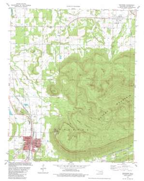
Heavener Topo Map Oklahoma
To zoom in, hover over the map of Heavener
USGS Topo Quad 34094h5 - 1:24,000 scale
| Topo Map Name: | Heavener |
| USGS Topo Quad ID: | 34094h5 |
| Print Size: | ca. 21 1/4" wide x 27" high |
| Southeast Coordinates: | 34.875° N latitude / 94.5° W longitude |
| Map Center Coordinates: | 34.9375° N latitude / 94.5625° W longitude |
| U.S. State: | OK |
| Filename: | o34094h5.jpg |
| Download Map JPG Image: | Heavener topo map 1:24,000 scale |
| Map Type: | Topographic |
| Topo Series: | 7.5´ |
| Map Scale: | 1:24,000 |
| Source of Map Images: | United States Geological Survey (USGS) |
| Alternate Map Versions: |
Heavener OK 1981, updated 1981 Download PDF Buy paper map Heavener OK 2010 Download PDF Buy paper map Heavener OK 2013 Download PDF Buy paper map Heavener OK 2016 Download PDF Buy paper map |
1:24,000 Topo Quads surrounding Heavener
> Back to 34094e1 at 1:100,000 scale
> Back to 34094a1 at 1:250,000 scale
> Back to U.S. Topo Maps home
Heavener topo map: Gazetteer
Heavener: Airports
Municipal Airport elevation 180m 590′Heavener: Parks
Runestone State Park elevation 307m 1007′Heavener: Populated Places
Forest Hill elevation 164m 538′Heavener elevation 169m 554′
Monroe elevation 163m 534′
Heavener: Ranges
Poteau Mountain elevation 402m 1318′Heavener: Streams
Dry Creek elevation 183m 600′Horsepen Creek elevation 135m 442′
Wilson Creek elevation 153m 501′
Heavener: Summits
Lost Mountain elevation 232m 761′Middle Mountain elevation 398m 1305′
Round Mountain elevation 325m 1066′
Heavener digital topo map on disk
Buy this Heavener topo map showing relief, roads, GPS coordinates and other geographical features, as a high-resolution digital map file on DVD:


