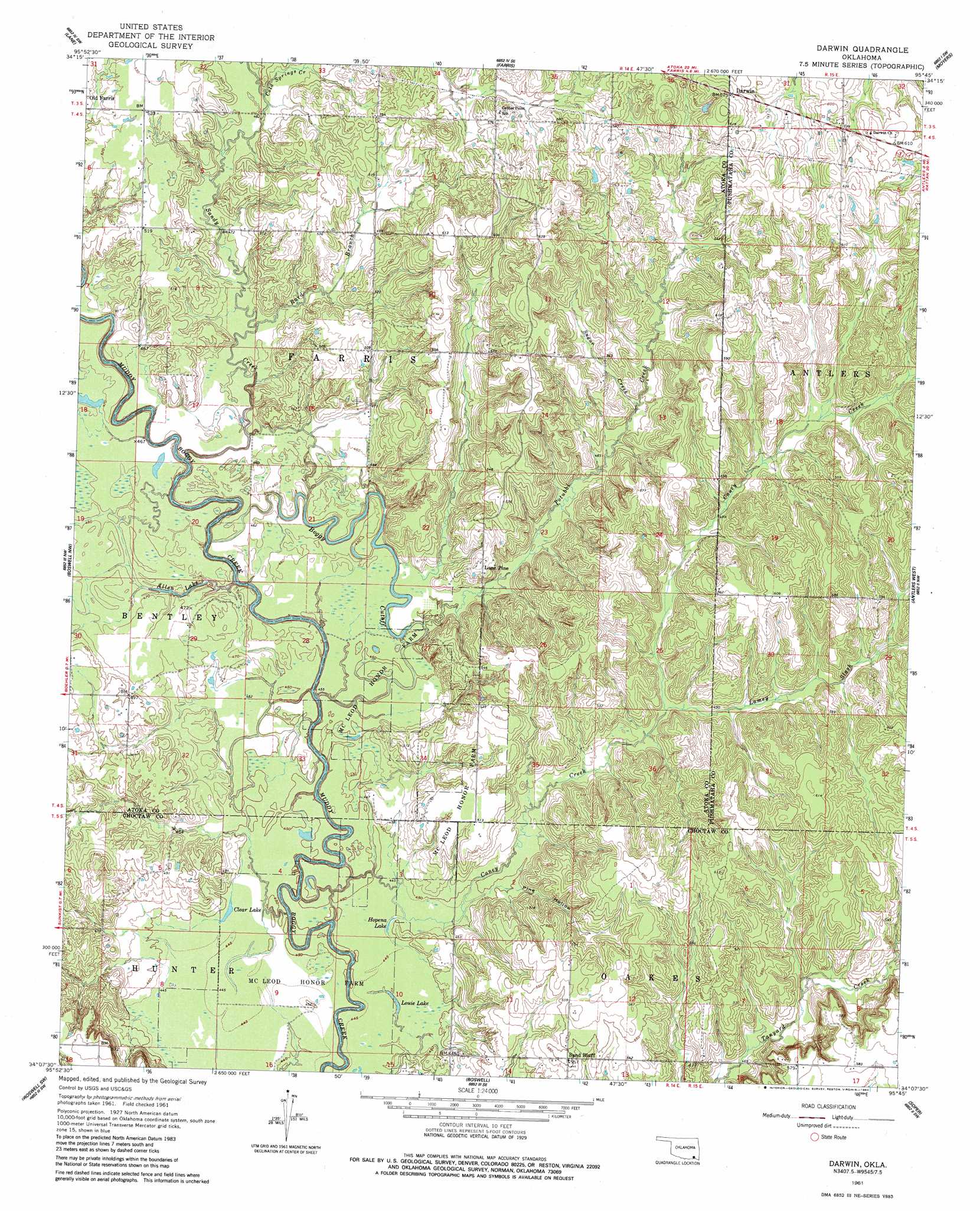
Darwin Topo Map Oklahoma
To zoom in, hover over the map of Darwin
USGS Topo Quad 34095b7 - 1:24,000 scale
| Topo Map Name: | Darwin |
| USGS Topo Quad ID: | 34095b7 |
| Print Size: | ca. 21 1/4" wide x 27" high |
| Southeast Coordinates: | 34.125° N latitude / 95.75° W longitude |
| Map Center Coordinates: | 34.1875° N latitude / 95.8125° W longitude |
| U.S. State: | OK |
| Filename: | o34095b7.jpg |
| Download Map JPG Image: | Darwin topo map 1:24,000 scale |
| Map Type: | Topographic |
| Topo Series: | 7.5´ |
| Map Scale: | 1:24,000 |
| Source of Map Images: | United States Geological Survey (USGS) |
| Alternate Map Versions: |
Darwin OK 1961, updated 1963 Download PDF Buy paper map Darwin OK 1961, updated 1983 Download PDF Buy paper map Darwin OK 2009 Download PDF Buy paper map Darwin OK 2012 Download PDF Buy paper map Darwin OK 2016 Download PDF Buy paper map |
1:24,000 Topo Quads surrounding Darwin
Stringtown |
Lane Nw |
Lane Ne |
Jumbo |
Dunbar |
Bruno |
Lane |
Farris |
Moyers |
Kosoma |
Bentley |
Boswell Nw |
Darwin |
Antlers West |
Antlers East |
Bennington North |
Boswell Sw |
Boswell |
Soper |
Hugo |
Bennington South |
Lake West |
New Oberlin |
Bluff |
Grant |
> Back to 34095a1 at 1:100,000 scale
> Back to 34094a1 at 1:250,000 scale
> Back to U.S. Topo Maps home
Darwin topo map: Gazetteer
Darwin: Areas
McLeod Honor Farm elevation 137m 449′Darwin: Lakes
Allen Lake elevation 137m 449′Clear Lake elevation 137m 449′
Dry Lake elevation 143m 469′
Hopena Lake elevation 136m 446′
Louie Lake elevation 134m 439′
Darwin: Populated Places
Darwin elevation 193m 633′Lone Pine elevation 162m 531′
Sand Bluff elevation 169m 554′
Darwin: Streams
Boggy Cutoff elevation 130m 426′Caney Creek elevation 132m 433′
Cold Springs Creek elevation 146m 479′
Lamey Slash elevation 143m 469′
Potubbi Creek elevation 135m 442′
Rard Branch elevation 140m 459′
Sand Branch elevation 133m 436′
Sandy Creek elevation 133m 436′
Sugar Creek elevation 150m 492′
Darwin: Valleys
Pine Hollow elevation 139m 456′Darwin digital topo map on disk
Buy this Darwin topo map showing relief, roads, GPS coordinates and other geographical features, as a high-resolution digital map file on DVD: