Moyers Topo Map Oklahoma
To zoom in, hover over the map of Moyers
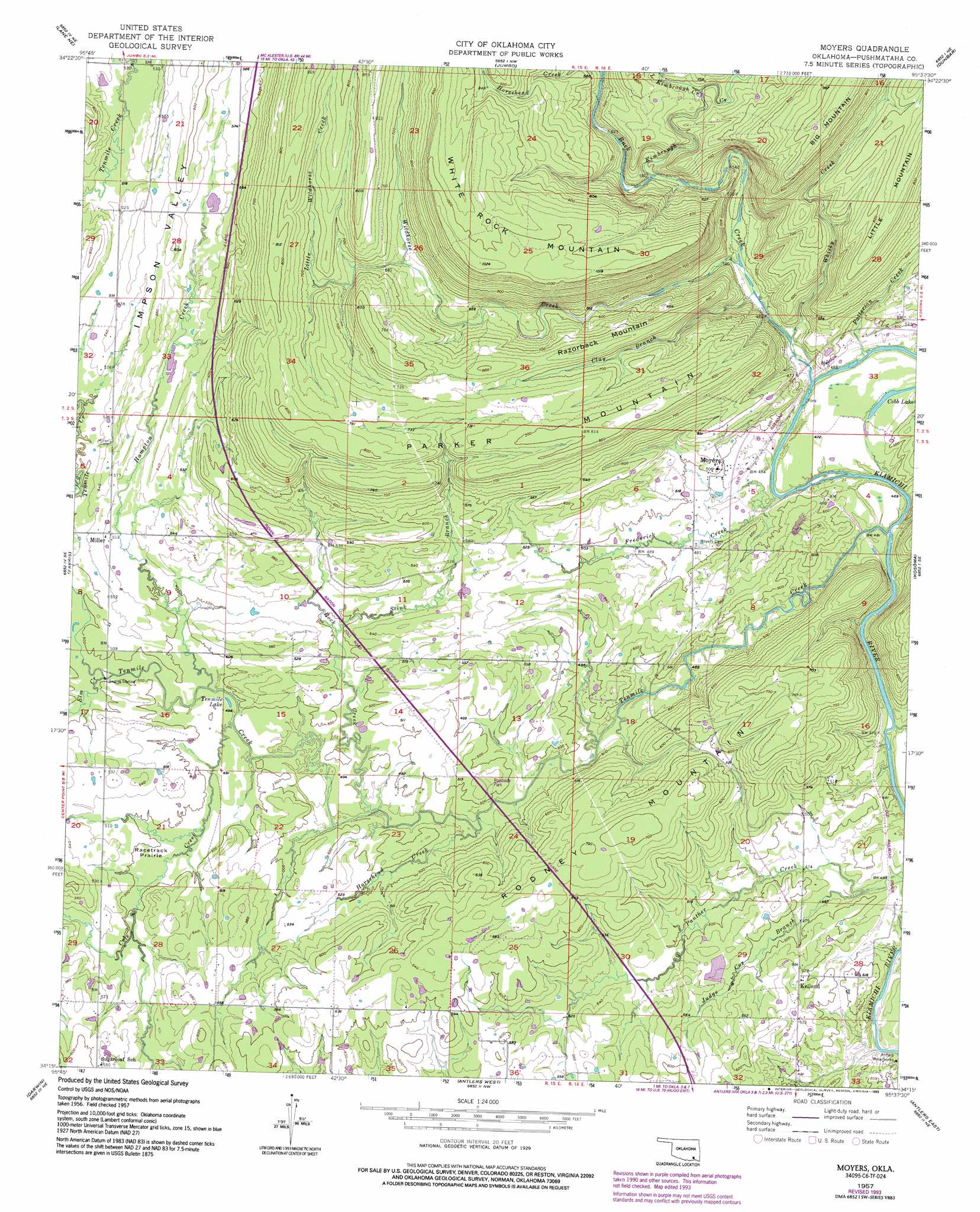
USGS Topo Quad 34095c6 - 1:24,000 scale
| Topo Map Name: | Moyers |
| USGS Topo Quad ID: | 34095c6 |
| Print Size: | ca. 21 1/4" wide x 27" high |
| Southeast Coordinates: | 34.25° N latitude / 95.625° W longitude |
| Map Center Coordinates: | 34.3125° N latitude / 95.6875° W longitude |
| U.S. State: | OK |
| Filename: | o34095c6.jpg |
| Download Map JPG Image: | Moyers topo map 1:24,000 scale |
| Map Type: | Topographic |
| Topo Series: | 7.5´ |
| Map Scale: | 1:24,000 |
| Source of Map Images: | United States Geological Survey (USGS) |
| Alternate Map Versions: |
Moyers OK 1957, updated 1958 Download PDF Buy paper map Moyers OK 1957, updated 1975 Download PDF Buy paper map Moyers OK 1957, updated 1993 Download PDF Buy paper map Moyers OK 2010 Download PDF Buy paper map Moyers OK 2012 Download PDF Buy paper map Moyers OK 2016 Download PDF Buy paper map |
1:24,000 Topo Quads surrounding Moyers
Limestone Gap |
Redden |
Daisy |
Adel |
Stanley |
Lane Nw |
Lane Ne |
Jumbo |
Dunbar |
Snow |
Lane |
Farris |
Moyers |
Kosoma |
Finley |
Boswell Nw |
Darwin |
Antlers West |
Antlers East |
Rattan |
Boswell Sw |
Boswell |
Soper |
Hugo |
Hugo Dam |
> Back to 34095a1 at 1:100,000 scale
> Back to 34094a1 at 1:250,000 scale
> Back to U.S. Topo Maps home
Moyers topo map: Gazetteer
Moyers: Flats
Racetrack Prairie elevation 150m 492′Moyers: Lakes
Cobb Lake elevation 145m 475′Tenmile Lake elevation 147m 482′
Moyers: Populated Places
Kellond elevation 160m 524′Miller elevation 157m 515′
Moyers elevation 152m 498′
Moyers: Streams
Buck Creek elevation 140m 459′Clay Branch elevation 142m 465′
Cole Creek elevation 146m 479′
Elm Creek elevation 146m 479′
Frederick Creek elevation 141m 462′
Hampton Creek elevation 146m 479′
Horsehead Creek elevation 191m 626′
Horsehead Creek elevation 140m 459′
Kimbrough Creek elevation 176m 577′
Little Kimbrough Creek elevation 213m 698′
Little Wildhorse Creek elevation 195m 639′
Panther Creek elevation 141m 462′
Patterson Creek elevation 140m 459′
Rock Creek elevation 141m 462′
Stink Branch elevation 151m 495′
Tenmile Creek elevation 134m 439′
Whisky Creek elevation 140m 459′
Wildhorse Creek elevation 145m 475′
Moyers: Summits
Parker Mountain elevation 248m 813′Razorback Mountain elevation 245m 803′
Rodney Mountain elevation 233m 764′
White Rock Mountain elevation 313m 1026′
Moyers: Valleys
Impson Valley elevation 153m 501′Moyers digital topo map on disk
Buy this Moyers topo map showing relief, roads, GPS coordinates and other geographical features, as a high-resolution digital map file on DVD: