Wapanucka North Topo Map Oklahoma
To zoom in, hover over the map of Wapanucka North
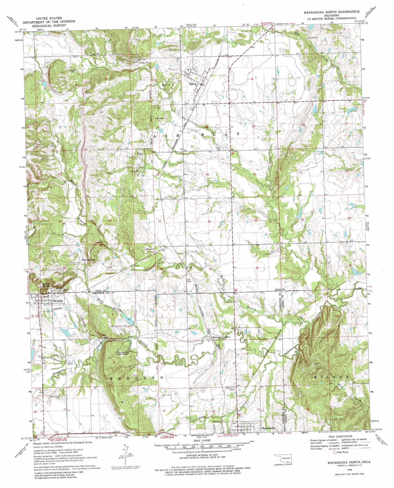
USGS Topo Quad 34096d4 - 1:24,000 scale
| Topo Map Name: | Wapanucka North |
| USGS Topo Quad ID: | 34096d4 |
| Print Size: | ca. 21 1/4" wide x 27" high |
| Southeast Coordinates: | 34.375° N latitude / 96.375° W longitude |
| Map Center Coordinates: | 34.4375° N latitude / 96.4375° W longitude |
| U.S. State: | OK |
| Filename: | o34096d4.jpg |
| Download Map JPG Image: | Wapanucka North topo map 1:24,000 scale |
| Map Type: | Topographic |
| Topo Series: | 7.5´ |
| Map Scale: | 1:24,000 |
| Source of Map Images: | United States Geological Survey (USGS) |
| Alternate Map Versions: |
Wapanucka North OK 1969, updated 1971 Download PDF Buy paper map Wapanucka North OK 1969, updated 1980 Download PDF Buy paper map Wapanucka North OK 2009 Download PDF Buy paper map Wapanucka North OK 2012 Download PDF Buy paper map Wapanucka North OK 2016 Download PDF Buy paper map |
1:24,000 Topo Quads surrounding Wapanucka North
Ahloso |
Stonewall |
Lula |
Tupelo Ne |
Parker |
Fittstown |
Harden City |
Tupelo |
Centrahoma |
Coalgate |
Connerville |
Connerville Ne |
Wapanucka North |
Olney |
Lehigh |
Reagan |
Connerville Se |
Wapanucka South |
Boggy Depot |
Tushka |
Kingston North |
Milburn |
Caddo Nw |
Caddo North |
Caney |
> Back to 34096a1 at 1:100,000 scale
> Back to 34096a1 at 1:250,000 scale
> Back to U.S. Topo Maps home
Wapanucka North topo map: Gazetteer
Wapanucka North: Dams
Delaware Creek Site 11 Dam elevation 200m 656′Delaware Creek Site 12 Dam elevation 197m 646′
Delaware Creek Site 14b Dam elevation 244m 800′
Delaware Creek Site 14c Dam elevation 245m 803′
Delaware Creek Site 2 Dam elevation 180m 590′
Leader Middle Clear Boggy Creek 2 Dam elevation 183m 600′
Leader Middle Clear Boggy Creek 5 Dam elevation 182m 597′
Leader Middle Clear Boggy Creek 6 Dam elevation 185m 606′
Leader Middle Clear Boggy Creek-1 Dam elevation 177m 580′
Pope Lake Dam elevation 209m 685′
Upper Clear Boggy Creek Site 10 Dam elevation 245m 803′
Wapanucka North: Populated Places
Bromide elevation 216m 708′Bromide Junction elevation 183m 600′
Clarita elevation 206m 675′
Wapanucka North: Post Offices
Clarita Post Office elevation 206m 675′Wapanucka North: Reservoirs
Delaware Creek Site 11 Reservoir elevation 200m 656′Delaware Creek Site 12 Reservoir elevation 197m 646′
Delaware Creek Site 14b Reservoir elevation 244m 800′
Delaware Creek Site 14c Reservoir elevation 245m 803′
Delaware Creek Site 2 Reservoir elevation 180m 590′
Leader Middle Clear Boggy Creek 2 Reservoir elevation 183m 600′
Leader Middle Clear Boggy Creek 5 Reservoir elevation 182m 597′
Leader Middle Clear Boggy Creek 6 Reservoir elevation 185m 606′
Leader Middle Clear Boggy Creek-1 Reservoir elevation 177m 580′
Mary J Ranch Lake elevation 209m 685′
Upper Clear Boggy Creek Site 10 Reservoir elevation 245m 803′
Wapanucka North: Springs
Sulphur Springs elevation 228m 748′Wide Springs elevation 217m 711′
Wapanucka North: Streams
Houghtubby Branch elevation 199m 652′Little Delaware Creek elevation 190m 623′
Sandy Creek elevation 175m 574′
Walnut Branch elevation 172m 564′
Wide Springs Branch elevation 182m 597′
Wapanucka North digital topo map on disk
Buy this Wapanucka North topo map showing relief, roads, GPS coordinates and other geographical features, as a high-resolution digital map file on DVD: