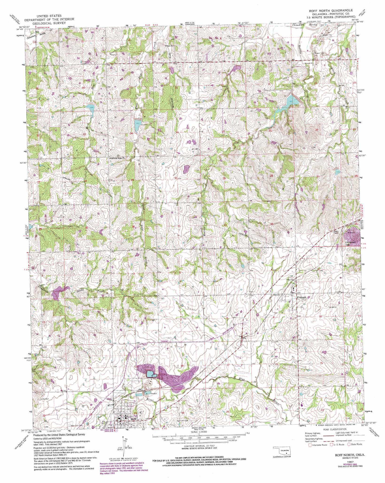
Roff North Topo Map Oklahoma
To zoom in, hover over the map of Roff North
USGS Topo Quad 34096f7 - 1:24,000 scale
| Topo Map Name: | Roff North |
| USGS Topo Quad ID: | 34096f7 |
| Print Size: | ca. 21 1/4" wide x 27" high |
| Southeast Coordinates: | 34.625° N latitude / 96.75° W longitude |
| Map Center Coordinates: | 34.6875° N latitude / 96.8125° W longitude |
| U.S. State: | OK |
| Filename: | o34096f7.jpg |
| Download Map JPG Image: | Roff North topo map 1:24,000 scale |
| Map Type: | Topographic |
| Topo Series: | 7.5´ |
| Map Scale: | 1:24,000 |
| Source of Map Images: | United States Geological Survey (USGS) |
| Alternate Map Versions: |
Roff North OK 1967, updated 1968 Download PDF Buy paper map Roff North OK 1967, updated 1991 Download PDF Buy paper map Roff North OK 1967, updated 1993 Download PDF Buy paper map Roff North OK 2009 Download PDF Buy paper map Roff North OK 2013 Download PDF Buy paper map Roff North OK 2016 Download PDF Buy paper map |
1:24,000 Topo Quads surrounding Roff North
Wanette |
Asher |
Konawa |
Vamoosa |
Sasakwa |
Byars |
Stratford |
Vanoss |
Ada |
Francis |
Pauls Valley Ne |
Hart |
Roff North |
Ahloso |
Stonewall |
Davis |
Sulphur North |
Roff South |
Fittstown |
Harden City |
Dougherty |
Sulphur South |
Mill Creek |
Connerville |
Connerville Ne |
> Back to 34096e1 at 1:100,000 scale
> Back to 34096a1 at 1:250,000 scale
> Back to U.S. Topo Maps home
Roff North topo map: Gazetteer
Roff North: Dams
Oknoname 11904 Dam elevation 332m 1089′Sandy Creek Site 11 Dam elevation 335m 1099′
Sandy Creek Site 3 Dam elevation 335m 1099′
Sandy Creek Site 33 Dam elevation 297m 974′
Sandy Creek Site 4 Dam elevation 290m 951′
Sandy Creek Site 6 Dam elevation 306m 1003′
Sandy Creek Site 7 Dam elevation 317m 1040′
Sandy Creek Site 8 Dam elevation 320m 1049′
Roff North: Populated Places
Fitzhugh elevation 381m 1250′Roff elevation 383m 1256′
Roff North: Reservoirs
Oknoname 11904 Reservoir elevation 332m 1089′Sandy Creek Site 11 Reservoir elevation 335m 1099′
Sandy Creek Site 3 Reservoir elevation 335m 1099′
Sandy Creek Site 33 Reservoir elevation 297m 974′
Sandy Creek Site 4 Reservoir elevation 290m 951′
Sandy Creek Site 6 Reservoir elevation 306m 1003′
Sandy Creek Site 7 Reservoir elevation 317m 1040′
Sandy Creek Site 8 Reservoir elevation 320m 1049′
Roff North: Streams
Rodtky Creek elevation 280m 918′Roff North: Summits
Chimney Hill elevation 409m 1341′Roff North: Valleys
Dry Hollow elevation 299m 980′Roff North digital topo map on disk
Buy this Roff North topo map showing relief, roads, GPS coordinates and other geographical features, as a high-resolution digital map file on DVD: