Ada Topo Map Oklahoma
To zoom in, hover over the map of Ada
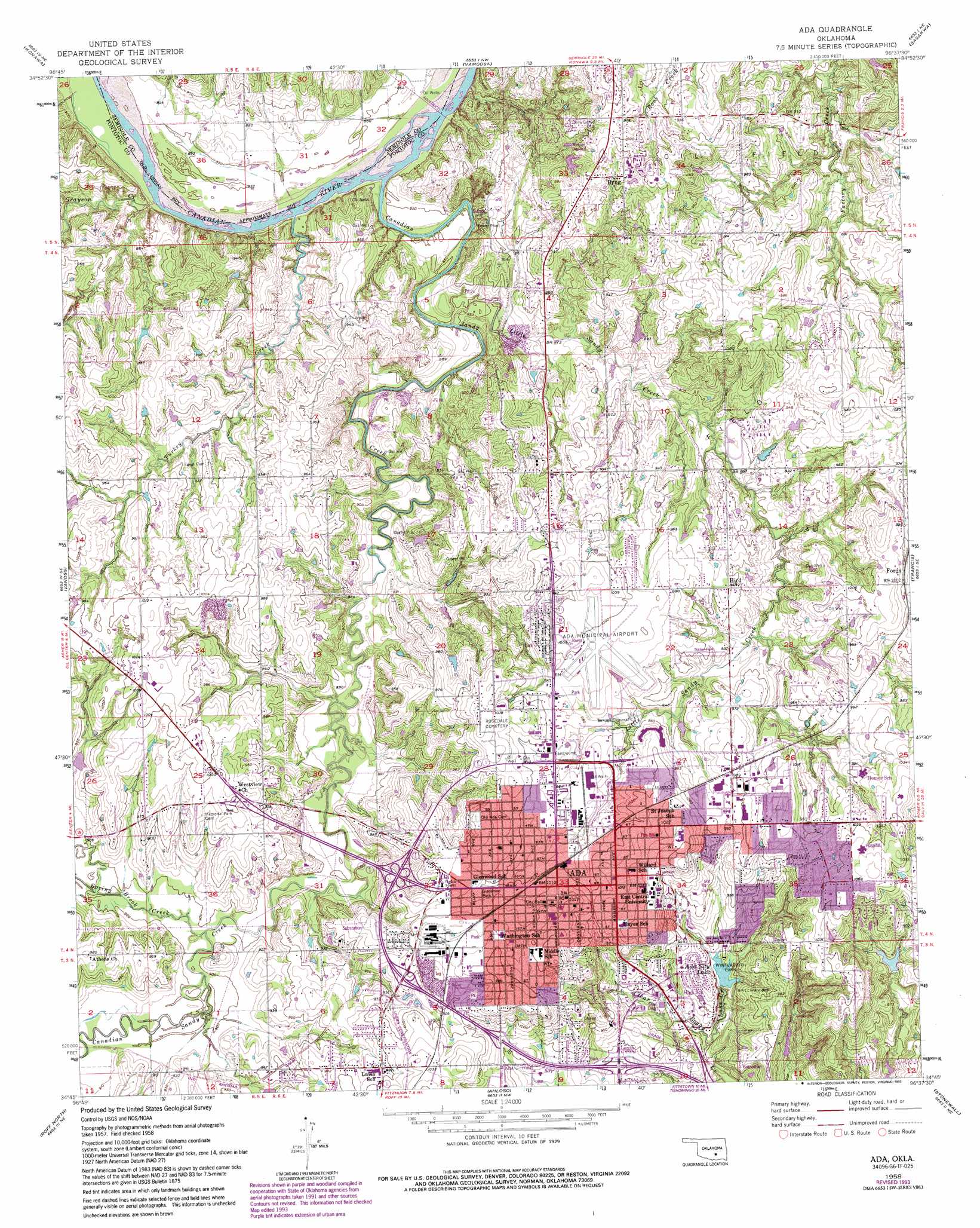
USGS Topo Quad 34096g6 - 1:24,000 scale
| Topo Map Name: | Ada |
| USGS Topo Quad ID: | 34096g6 |
| Print Size: | ca. 21 1/4" wide x 27" high |
| Southeast Coordinates: | 34.75° N latitude / 96.625° W longitude |
| Map Center Coordinates: | 34.8125° N latitude / 96.6875° W longitude |
| U.S. State: | OK |
| Filename: | o34096g6.jpg |
| Download Map JPG Image: | Ada topo map 1:24,000 scale |
| Map Type: | Topographic |
| Topo Series: | 7.5´ |
| Map Scale: | 1:24,000 |
| Source of Map Images: | United States Geological Survey (USGS) |
| Alternate Map Versions: |
Ada OK 1958, updated 1959 Download PDF Buy paper map Ada OK 1958, updated 1974 Download PDF Buy paper map Ada OK 1958, updated 1979 Download PDF Buy paper map Ada OK 1958, updated 1993 Download PDF Buy paper map Ada OK 2010 Download PDF Buy paper map Ada OK 2013 Download PDF Buy paper map Ada OK 2016 Download PDF Buy paper map |
1:24,000 Topo Quads surrounding Ada
Pearson |
Saint Louis |
Wolf |
Tate Mountain |
Holdenville |
Asher |
Konawa |
Vamoosa |
Sasakwa |
Allen |
Stratford |
Vanoss |
Ada |
Francis |
Steedman |
Hart |
Roff North |
Ahloso |
Stonewall |
Lula |
Sulphur North |
Roff South |
Fittstown |
Harden City |
Tupelo |
> Back to 34096e1 at 1:100,000 scale
> Back to 34096a1 at 1:250,000 scale
> Back to U.S. Topo Maps home
Ada topo map: Gazetteer
Ada: Airports
Ada Municipal Airport elevation 302m 990′Valley View Hospital Heliport elevation 327m 1072′
Ada: Dams
Ada City Dam elevation 271m 889′Sandy Creek Site 1 Dam elevation 284m 931′
Ada: Parks
Glenwood Park elevation 305m 1000′Wintersmith Park elevation 272m 892′
Ada: Populated Places
Ada elevation 308m 1010′Byng elevation 297m 974′
Hird elevation 293m 961′
Ada: Reservoirs
Ada City Lake elevation 269m 882′Ada City Lake elevation 271m 889′
Snady Creek Site 1 Reservoir elevation 284m 931′
Ada: Streams
Canadian Sandy Creek elevation 262m 859′Grayson Creek elevation 257m 843′
Lake Creek elevation 255m 836′
Little Sandy Creek elevation 257m 843′
Spring Brook Creek elevation 271m 889′
Turkey Creek elevation 257m 843′
Ada digital topo map on disk
Buy this Ada topo map showing relief, roads, GPS coordinates and other geographical features, as a high-resolution digital map file on DVD: