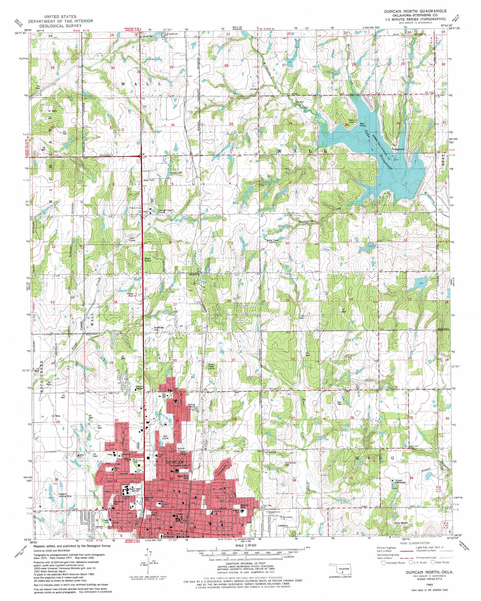
Duncan North Topo Map Oklahoma
To zoom in, hover over the map of Duncan North
USGS Topo Quad 34097e8 - 1:24,000 scale
| Topo Map Name: | Duncan North |
| USGS Topo Quad ID: | 34097e8 |
| Print Size: | ca. 21 1/4" wide x 27" high |
| Southeast Coordinates: | 34.5° N latitude / 97.875° W longitude |
| Map Center Coordinates: | 34.5625° N latitude / 97.9375° W longitude |
| U.S. State: | OK |
| Filename: | o34097e8.jpg |
| Download Map JPG Image: | Duncan North topo map 1:24,000 scale |
| Map Type: | Topographic |
| Topo Series: | 7.5´ |
| Map Scale: | 1:24,000 |
| Source of Map Images: | United States Geological Survey (USGS) |
| Alternate Map Versions: |
Marlow SW OK 1975, updated 1976 Download PDF Buy paper map Duncan North OK 1982, updated 1982 Download PDF Buy paper map Duncan North OK 2010 Download PDF Buy paper map Duncan North OK 2012 Download PDF Buy paper map Duncan North OK 2016 Download PDF Buy paper map |
1:24,000 Topo Quads surrounding Duncan North
Fletcher |
Rocky Ford |
Rush Springs |
East Roaring Creek |
Lindsay Sw |
Sterling |
Denton |
Marlow |
Bray |
Cox City |
Letitia |
Nellie |
Duncan North |
Hope |
Lake Fuqua |
Temple Nw |
Empire City |
Duncan South |
Harrisburg |
Velma |
Temple |
Corum |
Comanche |
Comanche Se |
Loco |
> Back to 34097e1 at 1:100,000 scale
> Back to 34096a1 at 1:250,000 scale
> Back to U.S. Topo Maps home
Duncan North topo map: Gazetteer
Duncan North: Airports
Copland Airport elevation 346m 1135′Duncan Regional Hospital Heliport elevation 350m 1148′
Duncan North: Dams
Oknoname 137022 Dam elevation 386m 1266′Oknoname 137023 Dam elevation 379m 1243′
Oknoname 137027 Dam elevation 372m 1220′
Oknoname 137028 Dam elevation 370m 1213′
Oknoname 137029 Dam elevation 383m 1256′
Rock Creek Site 13 Dam elevation 380m 1246′
Rock Creek Site 16 Dam elevation 365m 1197′
Wildhorse Creek Site 20 Dam elevation 358m 1174′
Wildhorse Creek Site 21 Dam elevation 365m 1197′
Wildhorse Creek Site 22 Dam elevation 346m 1135′
Duncan North: Lakes
Lake Humphreys elevation 357m 1171′Duncan North: Parks
Fuqua Park elevation 338m 1108′Hillcrest Park elevation 347m 1138′
McCasland Rotary Park elevation 351m 1151′
Memorial Park elevation 336m 1102′
Mighty Mite Park elevation 350m 1148′
Wisenant Park elevation 337m 1105′
Duncan North: Populated Places
Duncan elevation 343m 1125′Marlow elevation 390m 1279′
Duncan North: Reservoirs
Duncan Waterworks elevation 382m 1253′Oknoname 137022 Reservoir elevation 386m 1266′
Oknoname 137023 Reservoir elevation 379m 1243′
Oknoname 137027 Reservoir elevation 372m 1220′
Oknoname 137028 Reservoir elevation 370m 1213′
Oknoname 137029 Reservoir elevation 383m 1256′
Rock Creek Site 13 Reservoir elevation 380m 1246′
Rock Creek Site 16 Reservoir elevation 365m 1197′
Wildhorse Creek Site 20 Reservoir elevation 358m 1174′
Wildhorse Creek Site 21 Reservoir elevation 365m 1197′
Wildhorse Creek Site 22 Reservoir elevation 346m 1135′
Duncan North: Streams
Horsetooth Creek elevation 369m 1210′McCubbin Creek elevation 357m 1171′
Thompson Creek elevation 359m 1177′
Duncan North digital topo map on disk
Buy this Duncan North topo map showing relief, roads, GPS coordinates and other geographical features, as a high-resolution digital map file on DVD: