Arbuckle Hill Topo Map Oklahoma
To zoom in, hover over the map of Arbuckle Hill
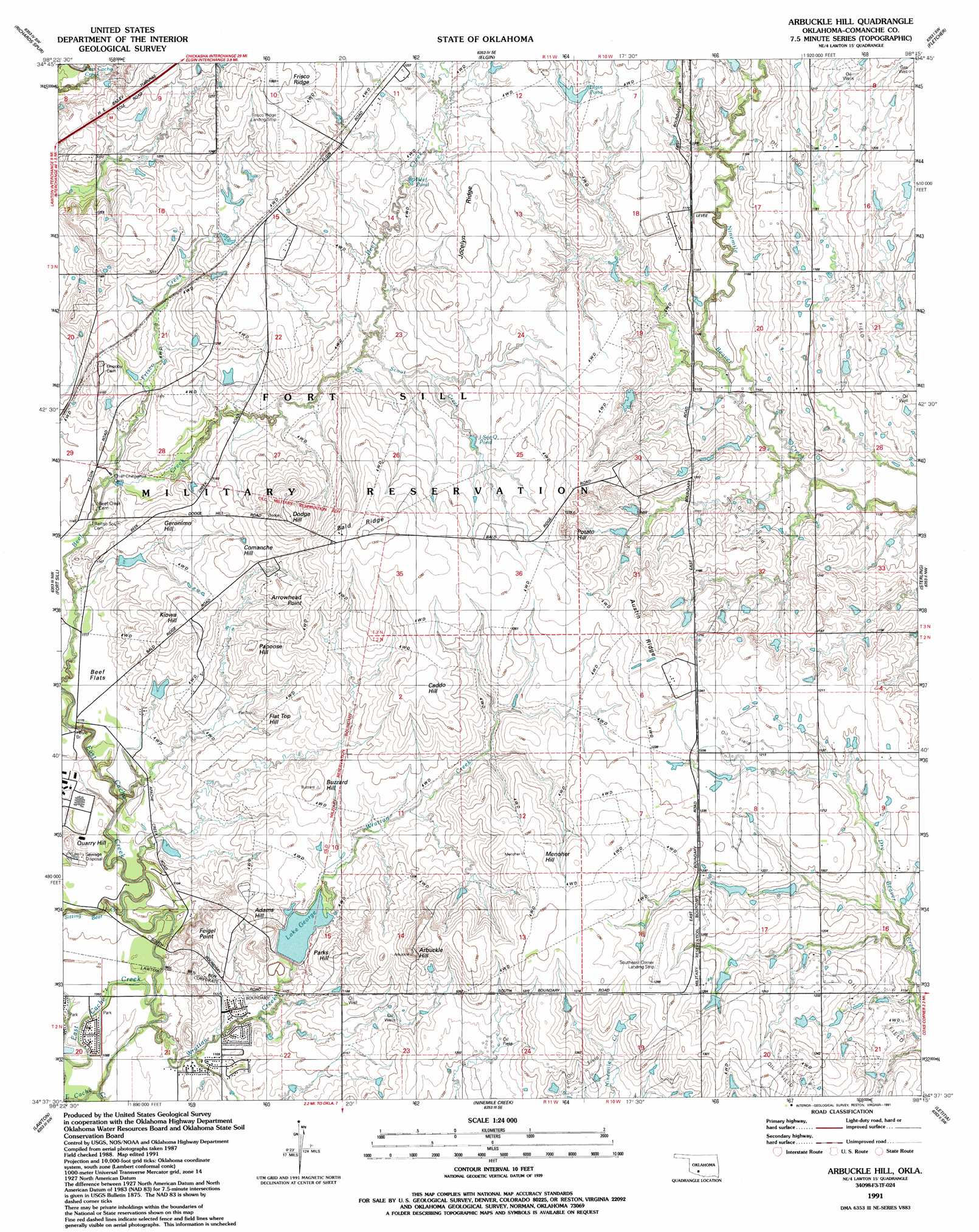
USGS Topo Quad 34098f3 - 1:24,000 scale
| Topo Map Name: | Arbuckle Hill |
| USGS Topo Quad ID: | 34098f3 |
| Print Size: | ca. 21 1/4" wide x 27" high |
| Southeast Coordinates: | 34.625° N latitude / 98.25° W longitude |
| Map Center Coordinates: | 34.6875° N latitude / 98.3125° W longitude |
| U.S. State: | OK |
| Filename: | o34098f3.jpg |
| Download Map JPG Image: | Arbuckle Hill topo map 1:24,000 scale |
| Map Type: | Topographic |
| Topo Series: | 7.5´ |
| Map Scale: | 1:24,000 |
| Source of Map Images: | United States Geological Survey (USGS) |
| Alternate Map Versions: |
Arbuckle Hill OK 1949, updated 1953 Download PDF Buy paper map Arbuckle Hill OK 1956, updated 1959 Download PDF Buy paper map Arbuckle Hill OK 1956, updated 1971 Download PDF Buy paper map Arbuckle Hill OK 1956, updated 1973 Download PDF Buy paper map Arbuckle Hill OK 1991, updated 1991 Download PDF Buy paper map Arbuckle Hill OK 2009 Download PDF Buy paper map Arbuckle Hill OK 2012 Download PDF Buy paper map Arbuckle Hill OK 2016 Download PDF Buy paper map |
1:24,000 Topo Quads surrounding Arbuckle Hill
Alden |
Boone |
Apache |
Cyril |
Laverty |
Meers |
Richards Spur |
Elgin |
Fletcher |
Rocky Ford |
Mount Scott |
Fort Sill |
Arbuckle Hill |
Sterling |
Denton |
Taupa |
Lawton |
Ninemile Creek |
Letitia |
Nellie |
Faxon |
Geronimo |
Walters Ne |
Temple Nw |
Empire City |
> Back to 34098e1 at 1:100,000 scale
> Back to 34098a1 at 1:250,000 scale
> Back to U.S. Topo Maps home
Arbuckle Hill topo map: Gazetteer
Arbuckle Hill: Airports
Frisco Ridge Airfield elevation 385m 1263′Southeast Corner Airfield elevation 394m 1292′
Arbuckle Hill: Bridges
Hoyle Bridge elevation 339m 1112′Arbuckle Hill: Cliffs
Bald Ridge elevation 387m 1269′Arbuckle Hill: Dams
Lake George Dam elevation 350m 1148′Oknoname 031006 Dam elevation 369m 1210′
Oknoname 031036 Dam elevation 369m 1210′
Arbuckle Hill: Flats
Beef Flats elevation 340m 1115′Arbuckle Hill: Reservoirs
Beef Pond elevation 368m 1207′Elgin Pond elevation 375m 1230′
Frisco Tank elevation 368m 1207′
I-See-O Tank elevation 367m 1204′
Lake George elevation 349m 1145′
Oknoname 031006 Reservoir elevation 369m 1210′
Oknoname 031036 Reservoir elevation 369m 1210′
Arbuckle Hill: Ridges
Austin Ridge elevation 390m 1279′Jocelyn Ridge elevation 383m 1256′
Arbuckle Hill: Streams
Frisco Creek elevation 342m 1122′Scout Creek elevation 357m 1171′
Sitting Bear Creek elevation 331m 1085′
Wrattan Creek elevation 333m 1092′
Arbuckle Hill: Summits
Adams Hill elevation 370m 1213′Arbuckle Hill elevation 403m 1322′
Arrowhead Point elevation 387m 1269′
Buzzard Hill elevation 369m 1210′
Caddo Hill elevation 391m 1282′
Comanche Hill elevation 371m 1217′
Dodge Hill elevation 396m 1299′
Feigel Point elevation 362m 1187′
Flat Top Hill elevation 365m 1197′
Geronimo Hill elevation 360m 1181′
Kiowa Hill elevation 372m 1220′
Menoher Hill elevation 393m 1289′
Papoose Hill elevation 367m 1204′
Parks Hill elevation 366m 1200′
Potato Hill elevation 389m 1276′
Quarry Hill elevation 348m 1141′
Arbuckle Hill digital topo map on disk
Buy this Arbuckle Hill topo map showing relief, roads, GPS coordinates and other geographical features, as a high-resolution digital map file on DVD: