Cactus Creek Topo Map Texas
To zoom in, hover over the map of Cactus Creek
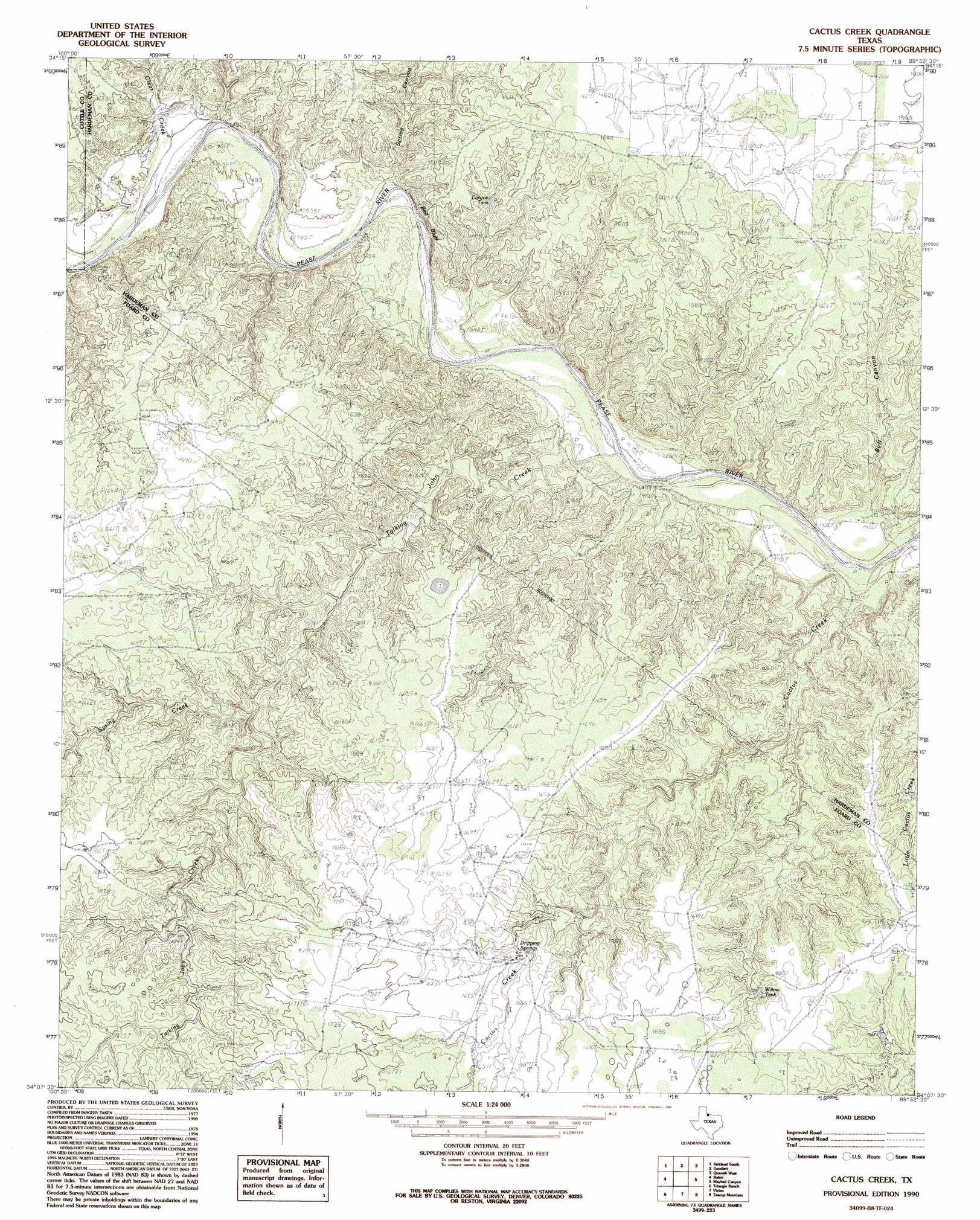
USGS Topo Quad 34099b8 - 1:24,000 scale
| Topo Map Name: | Cactus Creek |
| USGS Topo Quad ID: | 34099b8 |
| Print Size: | ca. 21 1/4" wide x 27" high |
| Southeast Coordinates: | 34.125° N latitude / 99.875° W longitude |
| Map Center Coordinates: | 34.1875° N latitude / 99.9375° W longitude |
| U.S. State: | TX |
| Filename: | o34099b8.jpg |
| Download Map JPG Image: | Cactus Creek topo map 1:24,000 scale |
| Map Type: | Topographic |
| Topo Series: | 7.5´ |
| Map Scale: | 1:24,000 |
| Source of Map Images: | United States Geological Survey (USGS) |
| Alternate Map Versions: |
Cactus Creek TX 1984, updated 1985 Download PDF Buy paper map Cactus Creek TX 1990, updated 1995 Download PDF Buy paper map Cactus Creek TX 2010 Download PDF Buy paper map Cactus Creek TX 2012 Download PDF Buy paper map Cactus Creek TX 2016 Download PDF Buy paper map |
1:24,000 Topo Quads surrounding Cactus Creek
Childress |
Kirkland North |
Williams |
North Groesbeck |
Eldorado |
Buckle L Ranch |
Kirkland South |
Goodlett |
Quanah West |
Quanah East |
Swearingen |
Baker |
Cactus Creek |
Maybell Canyon |
Big Mound |
Moons Camp |
Triangle Ranch |
Vivian |
Teacup Mountain |
Margaret |
Chalk |
Y Ranch |
Boiling Spring |
Foard City |
Crowell |
> Back to 34099a1 at 1:100,000 scale
> Back to 34098a1 at 1:250,000 scale
> Back to U.S. Topo Maps home
Cactus Creek topo map: Gazetteer
Cactus Creek: Cliffs
Red Bluff elevation 454m 1489′Cactus Creek: Reservoirs
Canyon Tank elevation 467m 1532′Willow Tank elevation 493m 1617′
Cactus Creek: Springs
Dripping Springs elevation 493m 1617′Talking John Springs elevation 485m 1591′
Cactus Creek: Streams
Cactus Creek elevation 434m 1423′Clear Creek elevation 446m 1463′
Spring Creek elevation 466m 1528′
Talking John Creek elevation 436m 1430′
Cactus Creek: Valleys
Bull Canyon elevation 437m 1433′Spring Canyon elevation 442m 1450′
Cactus Creek digital topo map on disk
Buy this Cactus Creek topo map showing relief, roads, GPS coordinates and other geographical features, as a high-resolution digital map file on DVD: