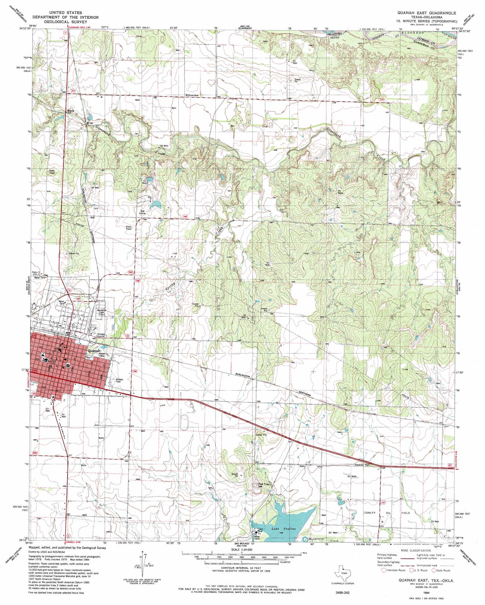
Quanah East Topo Map Texas
To zoom in, hover over the map of Quanah East
USGS Topo Quad 34099c6 - 1:24,000 scale
| Topo Map Name: | Quanah East |
| USGS Topo Quad ID: | 34099c6 |
| Print Size: | ca. 21 1/4" wide x 27" high |
| Southeast Coordinates: | 34.25° N latitude / 99.625° W longitude |
| Map Center Coordinates: | 34.3125° N latitude / 99.6875° W longitude |
| U.S. States: | TX, OK |
| Filename: | o34099c6.jpg |
| Download Map JPG Image: | Quanah East topo map 1:24,000 scale |
| Map Type: | Topographic |
| Topo Series: | 7.5´ |
| Map Scale: | 1:24,000 |
| Source of Map Images: | United States Geological Survey (USGS) |
| Alternate Map Versions: |
Quanah East TX 1984, updated 1985 Download PDF Buy paper map Quanah East TX 2010 Download PDF Buy paper map Quanah East TX 2012 Download PDF Buy paper map Quanah East TX 2016 Download PDF Buy paper map |
1:24,000 Topo Quads surrounding Quanah East
Hollis Sw |
Hollis Se |
Duke Sw |
Prairie Hill |
Olustee |
Williams |
North Groesbeck |
Eldorado |
Elmer Nw |
Ayers Island |
Goodlett |
Quanah West |
Quanah East |
Chillicothe |
Odell |
Cactus Creek |
Maybell Canyon |
Big Mound |
Medicine Mound |
Tolbert |
Vivian |
Teacup Mountain |
Margaret |
Warrior Hollow |
Rayland |
> Back to 34099a1 at 1:100,000 scale
> Back to 34098a1 at 1:250,000 scale
> Back to U.S. Topo Maps home
Quanah East topo map: Gazetteer
Quanah East: Dams
City of Quanah Lake Dam elevation 472m 1548′Lake Pauline Dam elevation 452m 1482′
Quanah Country Club North Lake Dam elevation 439m 1440′
Quanah Country Club South Lake Dam elevation 448m 1469′
Quanah East: Oilfields
Conley Oil Field elevation 449m 1473′Quanah East: Populated Places
Quanah elevation 479m 1571′Willowview elevation 442m 1450′
Quanah East: Reservoirs
City of Quanah Lake elevation 472m 1548′Lake Pauline elevation 452m 1482′
Quanah Country Club North Lake elevation 439m 1440′
Quanah Country Club South Lake elevation 448m 1469′
Quanah East: Streams
Spring Creek elevation 429m 1407′Quanah East: Summits
Flat Top elevation 489m 1604′Quanah East: Wells
Quanah Municipal Water Wells elevation 442m 1450′Quanah East digital topo map on disk
Buy this Quanah East topo map showing relief, roads, GPS coordinates and other geographical features, as a high-resolution digital map file on DVD: