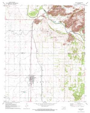
Blair Topo Map Oklahoma
To zoom in, hover over the map of Blair
USGS Topo Quad 34099g3 - 1:24,000 scale
| Topo Map Name: | Blair |
| USGS Topo Quad ID: | 34099g3 |
| Print Size: | ca. 21 1/4" wide x 27" high |
| Southeast Coordinates: | 34.75° N latitude / 99.25° W longitude |
| Map Center Coordinates: | 34.8125° N latitude / 99.3125° W longitude |
| U.S. State: | OK |
| Filename: | o34099g3.jpg |
| Download Map JPG Image: | Blair topo map 1:24,000 scale |
| Map Type: | Topographic |
| Topo Series: | 7.5´ |
| Map Scale: | 1:24,000 |
| Source of Map Images: | United States Geological Survey (USGS) |
| Alternate Map Versions: |
Blair OK 1971, updated 1973 Download PDF Buy paper map Blair OK 2010 Download PDF Buy paper map Blair OK 2012 Download PDF Buy paper map Blair OK 2016 Download PDF Buy paper map |
1:24,000 Topo Quads surrounding Blair
> Back to 34099e1 at 1:100,000 scale
> Back to 34098a1 at 1:250,000 scale
> Back to U.S. Topo Maps home
Blair topo map: Gazetteer
Blair: Canals
Blair Lateral elevation 452m 1482′Blair: Gaps
Cement Gap elevation 505m 1656′Blair: Populated Places
Blair elevation 446m 1463′City View elevation 462m 1515′
Blair: Streams
Elm Fork Red River elevation 447m 1466′Blair: Summits
Byrd Mountain elevation 592m 1942′King Mountain elevation 730m 2395′
Mountain Lugert elevation 577m 1893′
Stewart Mountain elevation 502m 1646′
Blair: Valleys
Devils Canyon elevation 442m 1450′Wisdom Canyon elevation 441m 1446′
Blair digital topo map on disk
Buy this Blair topo map showing relief, roads, GPS coordinates and other geographical features, as a high-resolution digital map file on DVD:


