Hughes Canyon Topo Map Texas
To zoom in, hover over the map of Hughes Canyon
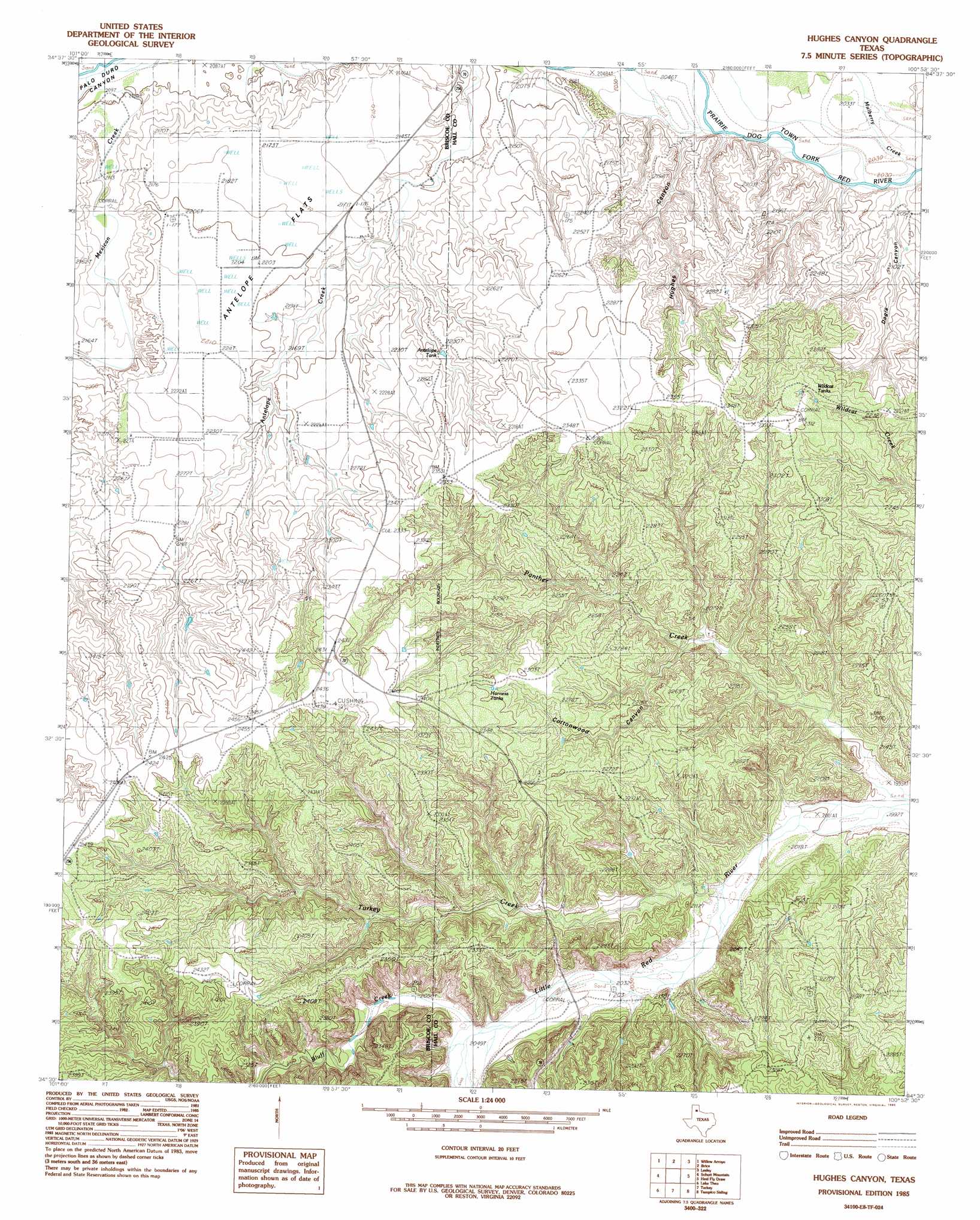
USGS Topo Quad 34100e8 - 1:24,000 scale
| Topo Map Name: | Hughes Canyon |
| USGS Topo Quad ID: | 34100e8 |
| Print Size: | ca. 21 1/4" wide x 27" high |
| Southeast Coordinates: | 34.5° N latitude / 100.875° W longitude |
| Map Center Coordinates: | 34.5625° N latitude / 100.9375° W longitude |
| U.S. State: | TX |
| Filename: | o34100e8.jpg |
| Download Map JPG Image: | Hughes Canyon topo map 1:24,000 scale |
| Map Type: | Topographic |
| Topo Series: | 7.5´ |
| Map Scale: | 1:24,000 |
| Source of Map Images: | United States Geological Survey (USGS) |
| Alternate Map Versions: |
Brice SW TX 1976, updated 1978 Download PDF Buy paper map Hughes Canyon TX 1985, updated 1985 Download PDF Buy paper map Hughes Canyon TX 2010 Download PDF Buy paper map Hughes Canyon TX 2012 Download PDF Buy paper map Hughes Canyon TX 2016 Download PDF Buy paper map |
1:24,000 Topo Quads surrounding Hughes Canyon
Paloduro |
Tate Arroyo |
Clarendon Sw |
Clarendon Se |
Hedley |
Hardscrabble Creek |
Willow Arroyo |
Brice |
Lesley |
Memphis Nw |
Indian Peak |
Schott Mountain |
Hughes Canyon |
Heel Fly Draw |
Plaska |
Hay Lake |
Lake Theo |
Turkey |
Tampico Siding |
Blue Tank Canyon |
Edgemon Lake |
Quitaque |
Folley |
North Windmill |
Cottonwood Camp |
> Back to 34100e1 at 1:100,000 scale
> Back to 34100a1 at 1:250,000 scale
> Back to U.S. Topo Maps home
Hughes Canyon topo map: Gazetteer
Hughes Canyon: Flats
Antelope Flats elevation 665m 2181′Hughes Canyon: Populated Places
Antelope Flats elevation 672m 2204′Hughes Canyon: Reservoirs
Antelope Tank elevation 677m 2221′Dogie Tank elevation 632m 2073′
Harness Tanks elevation 694m 2276′
Reed Tank elevation 678m 2224′
Wildcat Tanks elevation 696m 2283′
Hughes Canyon: Streams
Bitter Creek elevation 621m 2037′Bluff Creek elevation 624m 2047′
Mexican Creek elevation 639m 2096′
Mulberry Creek elevation 625m 2050′
Panther Creek elevation 607m 1991′
Turkey Creek elevation 616m 2020′
Hughes Canyon: Valleys
Cottonwood Canyon elevation 633m 2076′Dogle Canyon elevation 621m 2037′
Hughes Canyon elevation 628m 2060′
Hughes Canyon digital topo map on disk
Buy this Hughes Canyon topo map showing relief, roads, GPS coordinates and other geographical features, as a high-resolution digital map file on DVD: